
The Latin American Flags (& Game Quiz) - The Facts Institute
The Latin American flags from A-Z, recognized in every corner of the world. Flags are an important symbol that represent a nation.| The Facts Institute
Most of the hottest nations are in the tropics, clustered near the equator or within vast desert belts. These regions receive the sun’s rays almost directly overhead year-round. As a result, they experience consistently high solar radiation and little seasonal variation in... The post The 10 Hottest Countries in the World (2025) appeared first on Ultimate Kilimanjaro.| Ultimate Kilimanjaro
Most of the coldest nations are in the Northern Hemisphere, either inside or near the Arctic Circle. Areas that are inside the Arctic Circle, designated as north of 66°33′ N latitude, receive very little solar energy. The sun stays low in the... The post The 10 Coldest Countries in the World (2025) appeared first on Ultimate Kilimanjaro.| Ultimate Kilimanjaro
The Oceania flags from A-Z, recognized in every corner of the world. Flags are an important symbol that represent a nation. The post Learn The 16 Oceania Flags (& Game Quiz) appeared first on The Facts Institute.| The Facts Institute
The South American flags from A-Z, recognized in every corner of the world. Flags are an important symbol that represent a nation. The post Learn The South American Flags & Game Quiz (Updated 2025) appeared first on The Facts Institute.| The Facts Institute
The Latin American flags from A-Z, recognized in every corner of the world. Flags are an important symbol that represent a nation.| The Facts Institute

Play this unique twist on the classic snake game, where your mission is to eat as many apples as you can given their location and navigate the globe.| Engaging Data
See this complete list of countries that offer a Digital Nomad Visa (or an equivalent) for remote workers, freelancers & entrepreneurs. The post 54 Countries Offering a Digital Nomad Visa: Best for Remote Freelancers and Self-Employed Travelers appeared first on I am Aileen.| I am Aileen

Are you a remote worker or a perpetual traveler? Here is a list of the best countries for digital nomads around the world!| I am Aileen
The Caribbean flags from A-Z, recognized in every corner of the world. Flags are an important symbol that represent a nation. The post Learn The Caribbean Flags (Updated 2025) appeared first on The Facts Institute.| The Facts Institute
The Central American flags from A-Z, recognized in every corner of the world. Flags are an important symbol that represent a nation. The post Central American Flags (& Game Quiz) appeared first on The Facts Institute.| The Facts Institute

The North American flags from A-Z, recognized in every corner of the world. Flags are an important symbol that represent a nation.| The Facts Institute
The post How sharp was the decline in live births in Central and Eastern Europe after the collapse of communist regimes? appeared first on Significance magazine.| Significance magazine

Looking to live abroad and save on taxes? Discover the best tax-friendly countries for digital nomads and remote workers.| SavingK
Aloha,| Harmonic Code
Aloha,| Harmonic Code
How to stay in Europe longer and extend your stay in the Schengen Countries / Area for more than 3 months — the legal way? Here's how! The post How to Stay in Europe Longer Than 90 Days — Including the Schengen Countries: The Ultimate Guide (2025) appeared first on I am Aileen.| I am Aileen

This treemap shows the 10 largest economies in the world, including California which is the 4th largest, and has the smallest population.| Engaging Data

A detailed map of Tonga displaying its regions and major towns. Where is Tonga, and what does it look like geographically?| The Facts Institute

With globalization, moving to another country has become an easy step. Here are 5 countries with the best quality of life in the world.| GoExpat

Boost your knowledge of US geography with this all-in-one learning kit designed to master the 50 state capitals.| The Facts Institute
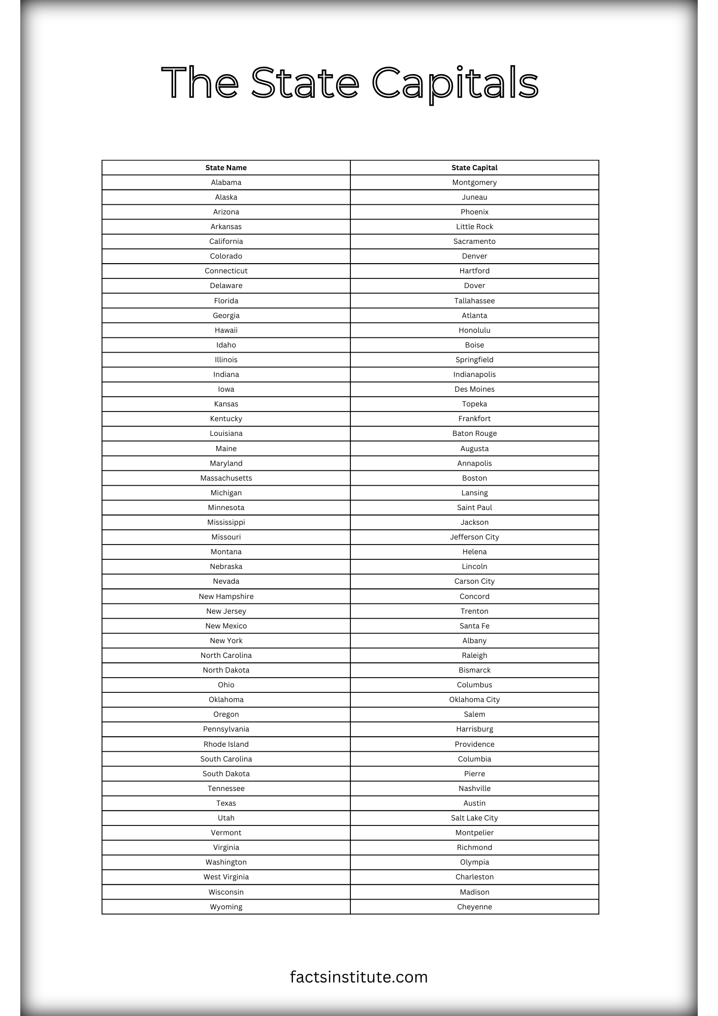
Looking for an easy way to learn all 50 U.S. state capitals? This printable US state capitals list is perfect for students, teachers, and trivia lovers!| The Facts Institute
The Asian flags from A-Z, recognized in every corner of the world. Flags are an important symbol that represent a nation.| The Facts Institute
In collaboration with MBSSE, the GRID3 team at Flowminder carried out an analysis using GIS and its optimisation algorithm to improve radio coverage and enhance education access during disease outbreaks. Der Beitrag Using data analytics to improve radio coverage and enhance education access during disease outbreaks in Sierra Leone erschien zuerst auf GRID3.| GRID3
The quick and effective reaction of the Government of Nigeria is underpinned by a National COVID-19 Multi-Sectoral Pandemic Response Plan. GRID3 Nigeria has been working closely with the Presidential Task Force to swiftly support the government’s efforts and integrate geospatial data solutions into their plans. Der Beitrag Taking on COVID-19 with data: Nigeria’s government collaborates with GRID3 on response and prevention erschien zuerst auf GRID3.| GRID3
Using building footprint data extracted from Ecopia Landbase Africa powered by Maxar, GRID3 has prioritised mapping extents for several dozen more African countries over the next two months. Der Beitrag Mapping settlement extents to support COVID-19 response efforts erschien zuerst auf GRID3.| GRID3
The first joint meeting of the GRID3 Nigeria National Steering and Technical Committees took place on Monday, February 10th, at the Federal Ministry of Finance headquarters in Abuja. The meeting was convened by the Chair of the Steering Committee, Mrs. Zainab Shamsuna Ahmed, who is the Minister of Finance, Budget, and National Planning. Der Beitrag GRID3 Nigeria National Steering and Technical Committees agree on project goals during first joint meeting erschien zuerst auf GRID3.| GRID3
In December 2019, GRID3 together with in-country partners in DRC, carried out a series of field tests in a range of urban and rural contexts to assess the suitability of a semi-automated approach to create pre-Enumeration Area boundaries. Der Beitrag GRID3 tests semi-automatic mapping of pre-Enumeration Areas to support census cartography in the Democratic Republic of the Congo erschien zuerst auf GRID3.| GRID3
The Nigerian Universal Basic Educational Commission (UBEC) and GRID3 Nigeria are working together to apply new geospatial data to achieve the desired impact of education for all Nigerians and reduce the rate of out-of-school children in the country. Der Beitrag How geospatial data can help solve Nigeria’s educational challenges erschien zuerst auf GRID3.| GRID3
Between November and December 2019, Nigeria’s National Bureau of Statistics (NBS) and National Population Commission (NPopC) became the first national statistical and population agencies to be trained on the gridded population survey sampling methodology for household survey design and implementation. Der Beitrag Nigeria’s national statistical and population agencies become first to be trained on gridded population survey sampling methodology erschien zuerst auf GRID3.| GRID3
The committees support Nigerian efforts to use geospatial data in the country’s continued pursuit of achieving sustainable development for everyone. Der Beitrag Nigeria’s Vice-President Yemi Osinbajo inaugurates GRID3 Nigeria National Steering and Technical Committees erschien zuerst auf GRID3.| GRID3

GRID3 experts joined world leaders, activists, demographers, scientists and other inspirational figures at the Nairobi Summit which centered on garnering commitments and creating the momentum necessary to fulfill the promises of Cairo.| GRID3
Today I'm letting Urble out into the wild. It's a little geography game in which a new city (displayed as a small square) appears every 5 seconds until there are 10 dots on screen (example below). The aim of Urble is to guess the country before the country shape appears- 50 seconds into the video. You can pause the video after the 10th dot (at 45 seconds) if you need more time. If you turn the sound on, you'll notice that when the 10th city is added it makes a different sound. I'm releasing t...| Stats, Maps n Pix

Test your geography skills and see if you can name all 50 states from their locations on a blank map! Where do you place on the leaderboard?| The Facts Institute
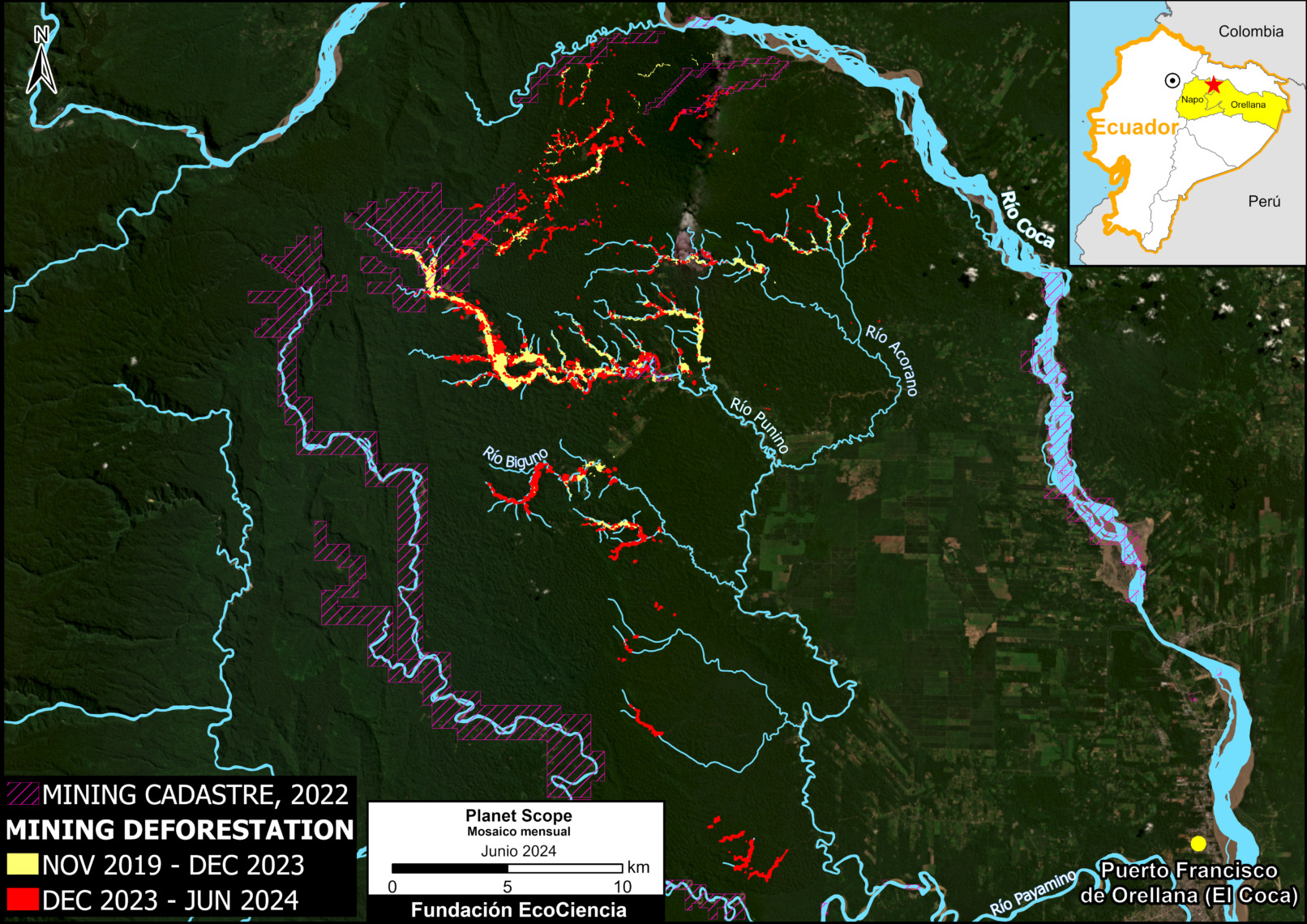
In a series of previous reports, we warned about the emergence and expansion of illegal mining deforestation in the heart of the Ecuadorian Amazon, in the area surrounding the Punino River, located between the provinces of Napo and Orellana (MAAP #182, MAAP #151). In the most recent report, we informed that this mining impact had […]| MAAP
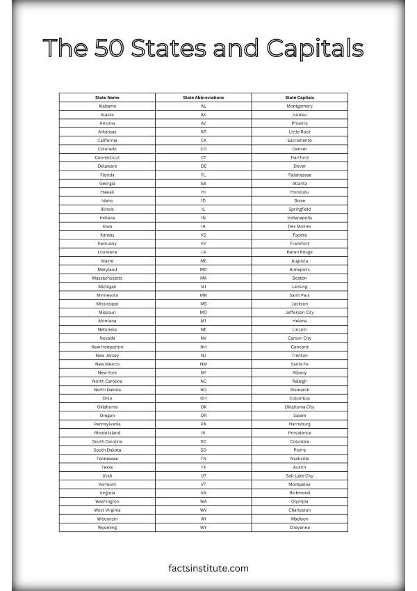
Free printable list of the 50 states and capitals for you to test your geography knowledge and review the capitals, states and abbreviations.| The Facts Institute

Boost your knowledge of US geography with this all-in-one learning kit to master the 50 states, their capitals, and abbreviations.| The Facts Institute

Free blank United States map for you to test your geography knowledge and review the capitals, states and abbreviations.| The Facts Institute

Capital cities of the Caribbean in alphabetical order, from Anguilla to the United States Virgin Islands. Discover Caribbean countries and dependencies and their most important cities.| The Facts Institute
Capital cities of Oceania in alphabetical order, from Australia to Vanuatu. Discover 16 Oceanian countries and their most important cities.| The Facts Institute
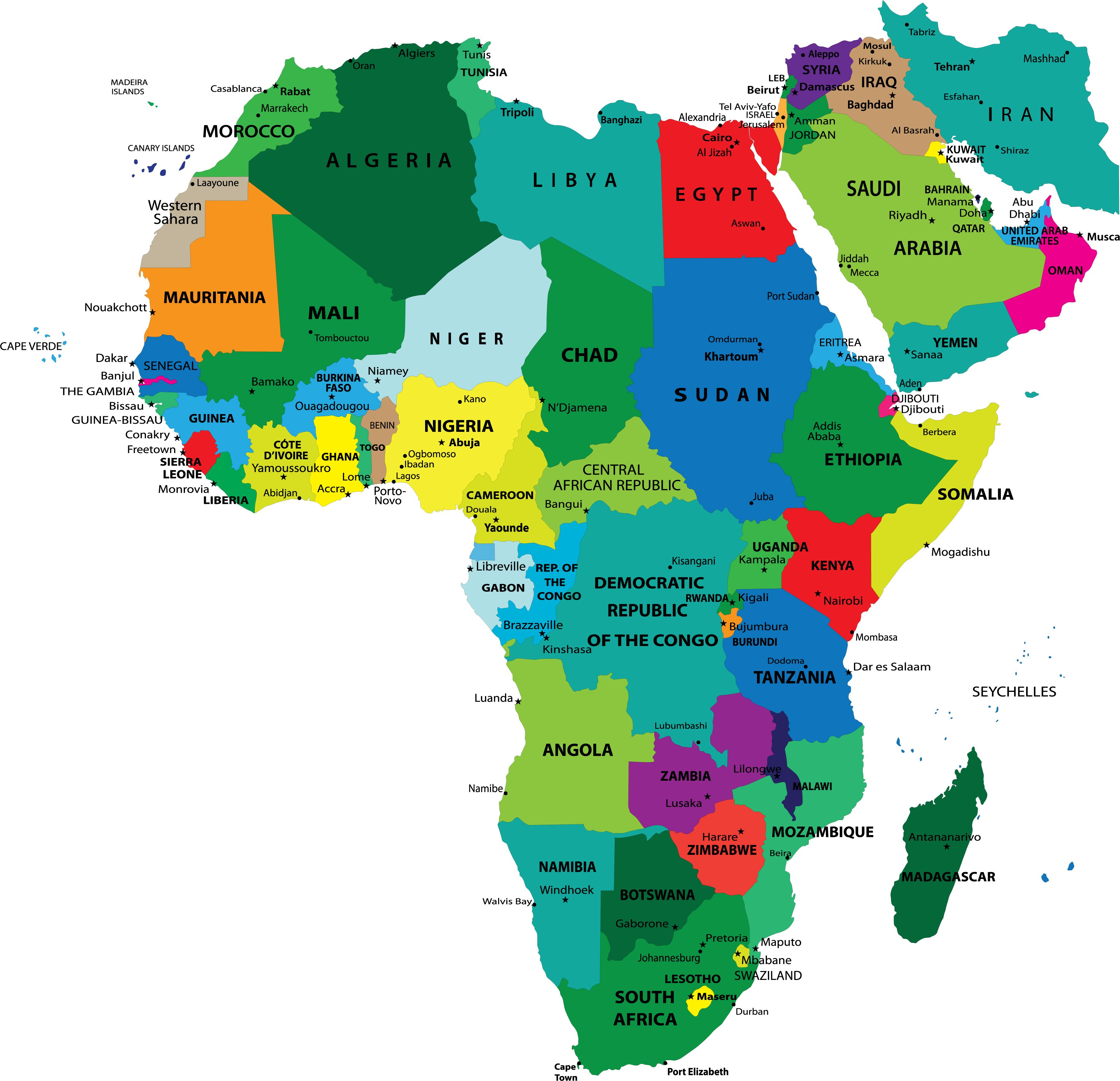
Capital cities of Africa in alphabetical order, from Algeria to Zimbabwe. Discover 54 African countries and their most important cities.| The Facts Institute

The US map is not just used for navigation. It offers a chance for us to explore diverse geography and compare its distinct regions.| The Facts Institute
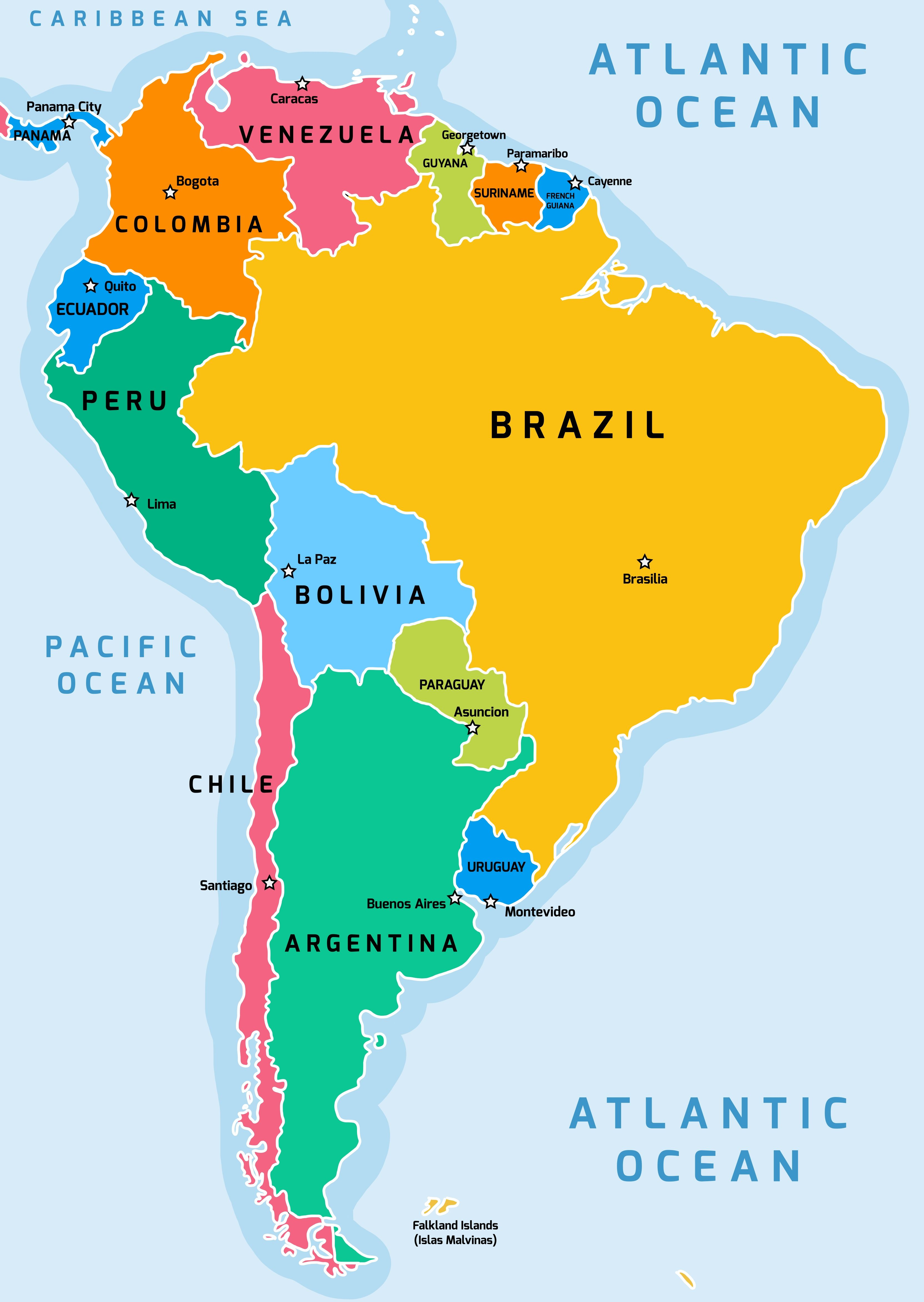
Capital cities of South America in alphabetical order, from Argentina to Venezuela. Discover South American countries and their most important cities.| The Facts Institute

Capital cities of North America in alphabetical order, from Antigua and Barbuda to the United States. Discover 23 North American countries and their most important cities.| The Facts Institute
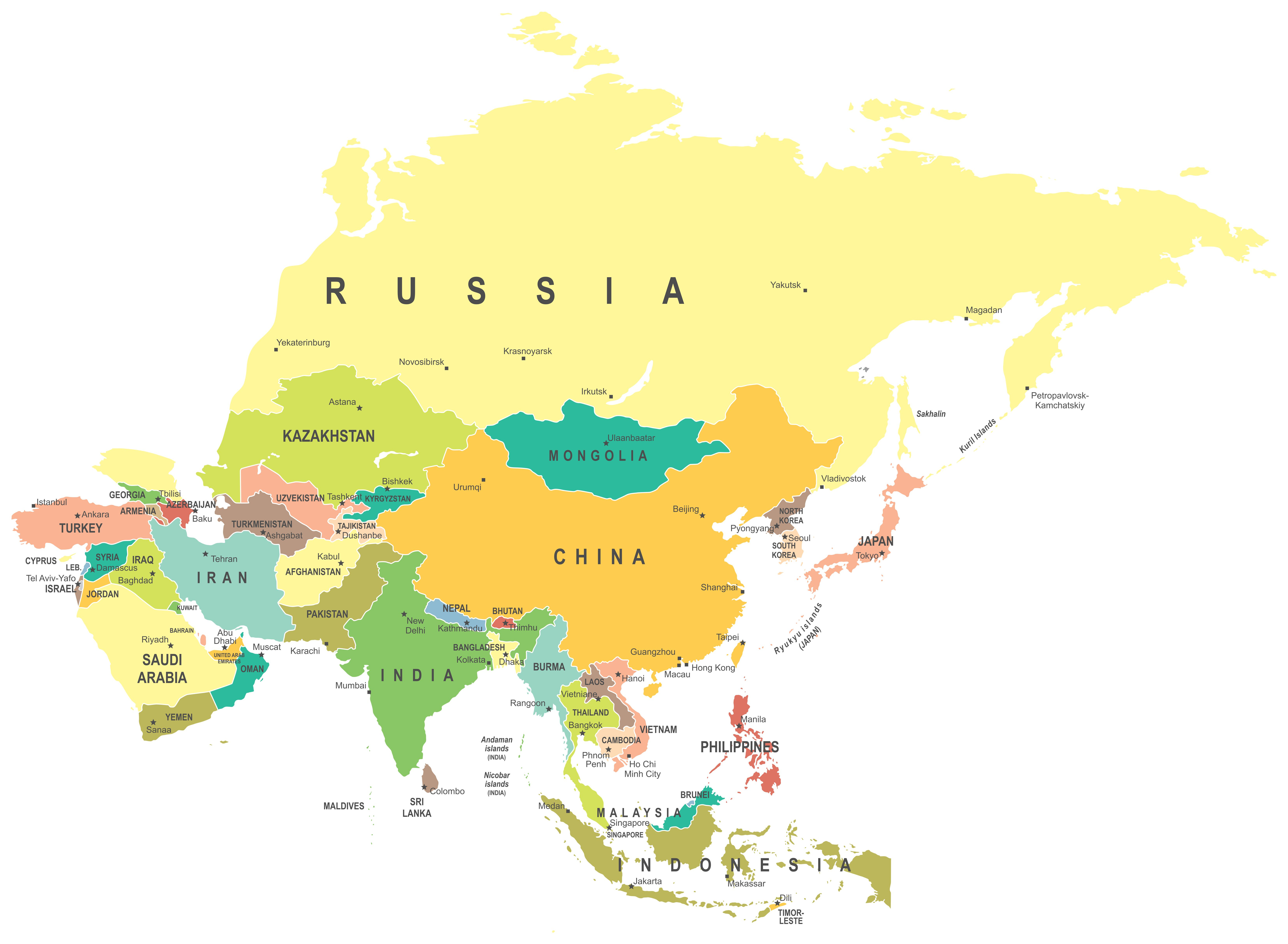
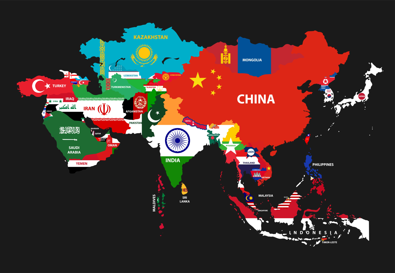
Capital cities of Asia in alphabetical order, from Afghanistan to Yemen. Discover Asian countries and their most important cities.| The Facts Institute
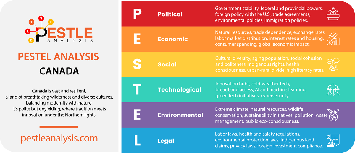
In Canada, every factor has a story. This PESTLE analysis uncovers how nature, grit, and ambition shape a nation built to endure.| PESTLE Analysis
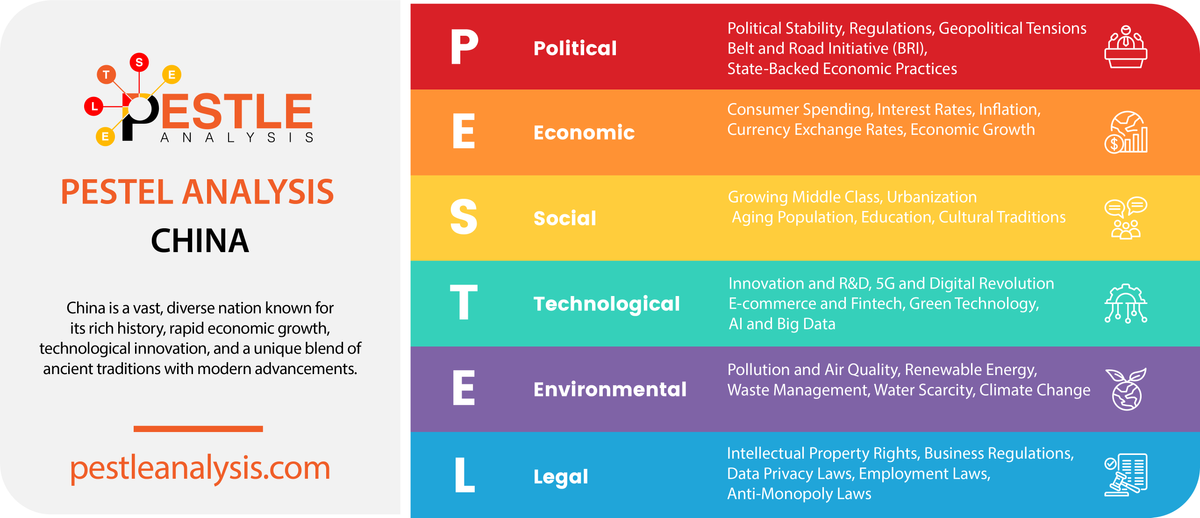
China’s got its PESTLE game on lock: politics, economy, and all. Just remember, it’s their rules, and they’re keeping score.| PESTLE Analysis

Germany’s grip on EU policy is slipping faster than a bald tire on wet pavement, while China’s EVs face roadblocks in Europe. Who’s driving this trade drama?| PESTLE Analysis

* On July 28, 2024, Nicolás Maduro was elected president of Venezuela for a third term. With 51.20 percent of votes in favor, the National Electoral Council announced Maduro’s victory in a contest in which nearly 59 percent of the electorate participated. Meanwhile, despite their defeat, Edmundo González and María Corina Machado -disqualified from running…Read more →| Alliance for Global Justice
I’ve been to 33 countries so far in my 31 years of life, and today, I’m ranking them from the worst to the best. Keep in mind that these are my own personal opinions and experiences. And since I’m 31, I do not care about yours. I’m honest and will be so about every single […] The post Ranking The 33 Countries I’ve Visited From Worst To Best appeared first on Gabriel Iosa.| Gabriel Iosa

Consider yourself a guru at Canadian trivia? Take a chance at our ultimate Canadian trivia quiz and see how you do!| Travel Trivia Challenge

If you're planning on visiting Albania as a digital nomad, read my ultimate guide to living in Albania for everything you need to know.| Goats On The Road
Children have a very similar life to our children in the United States, but of course there are a few differences that are interesting. One important thing that I learned when we moved to France years ago was that students learn cursive before printing. While some schools in the United States are opting to not […]| Mixminder
What time do you normally eat dinner? Did you know that people in Spain don’t start eating dinner until at least 8pm at the earliest? Restaurants don’t start opening for dinner until 8pm, but they really get crowded around 9pm to 9:30pm. Also, meals, especially dinner, are not quick. Dinner lasts at least 2 hours […]| Mixminder
Did you know that one of the most popular foods in Taiwan is called stinky tofu? It is a type of fermented tofu that, while delicious, has a really bad smell! It is commonly sold and eaten at night markets in Taipei, the capital city of Taiwan. In fact, there is an entire street in […]| Mixminder
It’s so fun for me to learn about different cultures and countries. It’s even more fun for me to teach about things that I’ve learned to my students and to my own children. Using an interactive notebook brings it all together with fun foldables and activities to help students remember the facts that they’ve learned. […]| Mixminder
Full of vast history and unique landmarks, each of America's 50 states has a story to tell and facts to uncover.| Travel Trivia Challenge
Test your knowledge and see if you can answer 20 FUN questions about the 50 US States. Warning: Some answers may surprise you!| Travel Trivia Challenge
