Together with the German Federal Agency for Cartography and Geodesy (BKG) we released a new version of the ohsome dashboard, introducing a new indicator for assessing the thematic accuracy of land cover data in OpenStreetMap (OSM). This development is part of a broader project together with BKG on OSM data quality evaluation. New indicator: Thematic […]| GIScience Blog
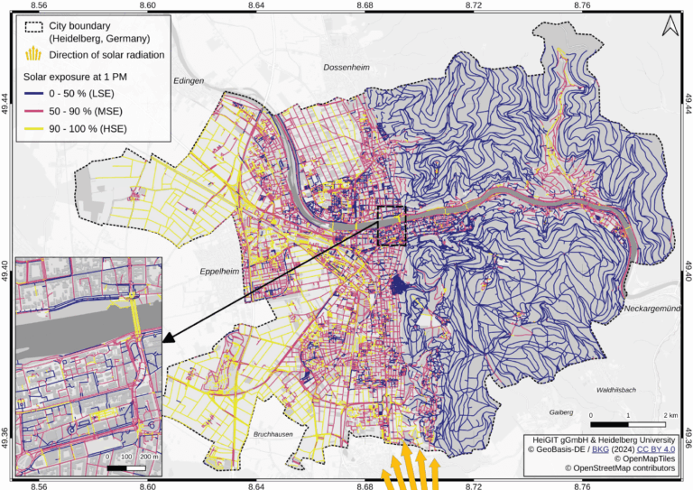
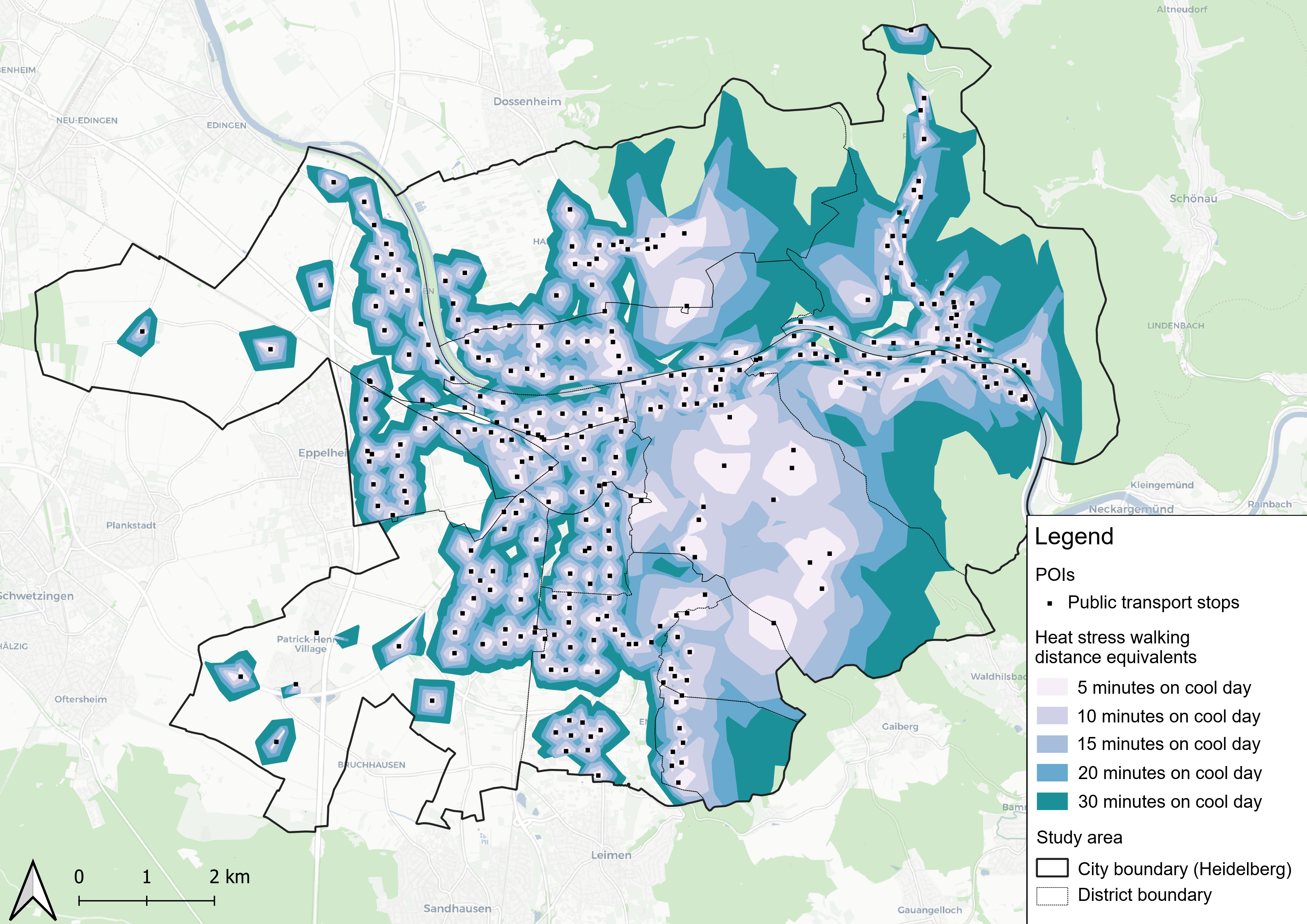
Using Heidelberg as a case study, researchers modeled time-dependent solar exposure for the entire pedestrian network by combining high-resolution DEM/DSM building and vegetation data with OpenStreetMap road data.| GIScience Blog
On January 24, 2010, Zeke Farwell completed the Long Trail. He had begun just two days earlier, connecting more than 50 segments of trail spanning over 200 miles. Motivated by “the longest and most well known hiking trail in Vermont”, Zeke often revisited portions of the trails in the years to come. Now I’m not revealing a secret FKT, but rather the completion of the Long Trail route on OpenStreetMap. OpenStreetMap is like Wikipedia …| Satoshi Village
The State of the Map US (SOTMUS) 2025 conference in Boston, MA was yet another fantastic gathering of cartographers, mappers, and map enthusiasts. Stamen was well-represented this year by Kelsey Taylor, Eric Brelsford, and Eric Rodenbeck. We presented two talks on Stamen projects related to open source tooling with maps. Now that we’re back in...| Stamen
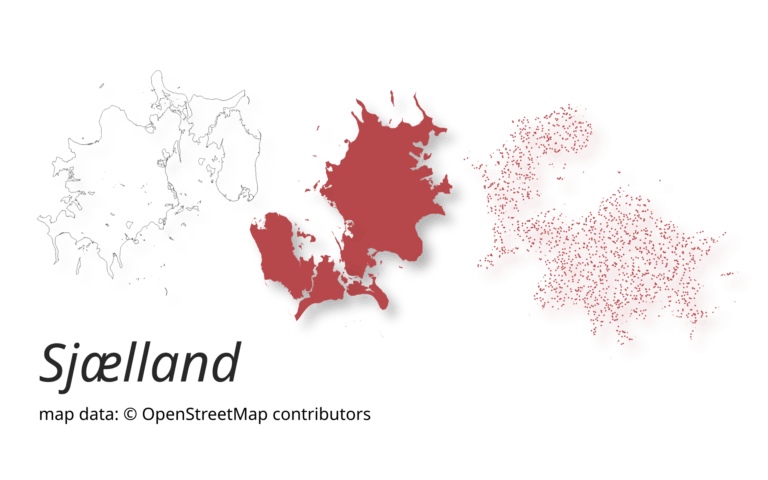
A new version of ohsome-planet (codename “Sjælland”) has been released. It is the newest version of HeiGIT´s command line tool, which transforms OpenStreetMap (history) PBF files into into an analysis-ready data format. We illustrate what ohsome-planet can do by assessing how many OSM edits used Bing Imagery as reference source.| GIScience Blog
This study introduces the isocalor approach to assess how solar exposure and heat stress impact pedestrian access to essential services in Heidelberg, using OpenStreetMap data and a customized openrouteservice routing engine.| GIScience Blog
The paper addresses the global shortage of detailed road surface data by leveraging street-view imagery from Mapillary and advanced deep learning techniques. Traditional datasets like OpenStreetMap (OSM) often lack comprehensive road surface attributes—with only about 30–40% coverage—hindering applications such as travel time estimation, disaster response routing, urban planning, and environmental assessments. To fill this gap, the paper proposes a novel approach that utilizes heterogen...| GIScience Blog
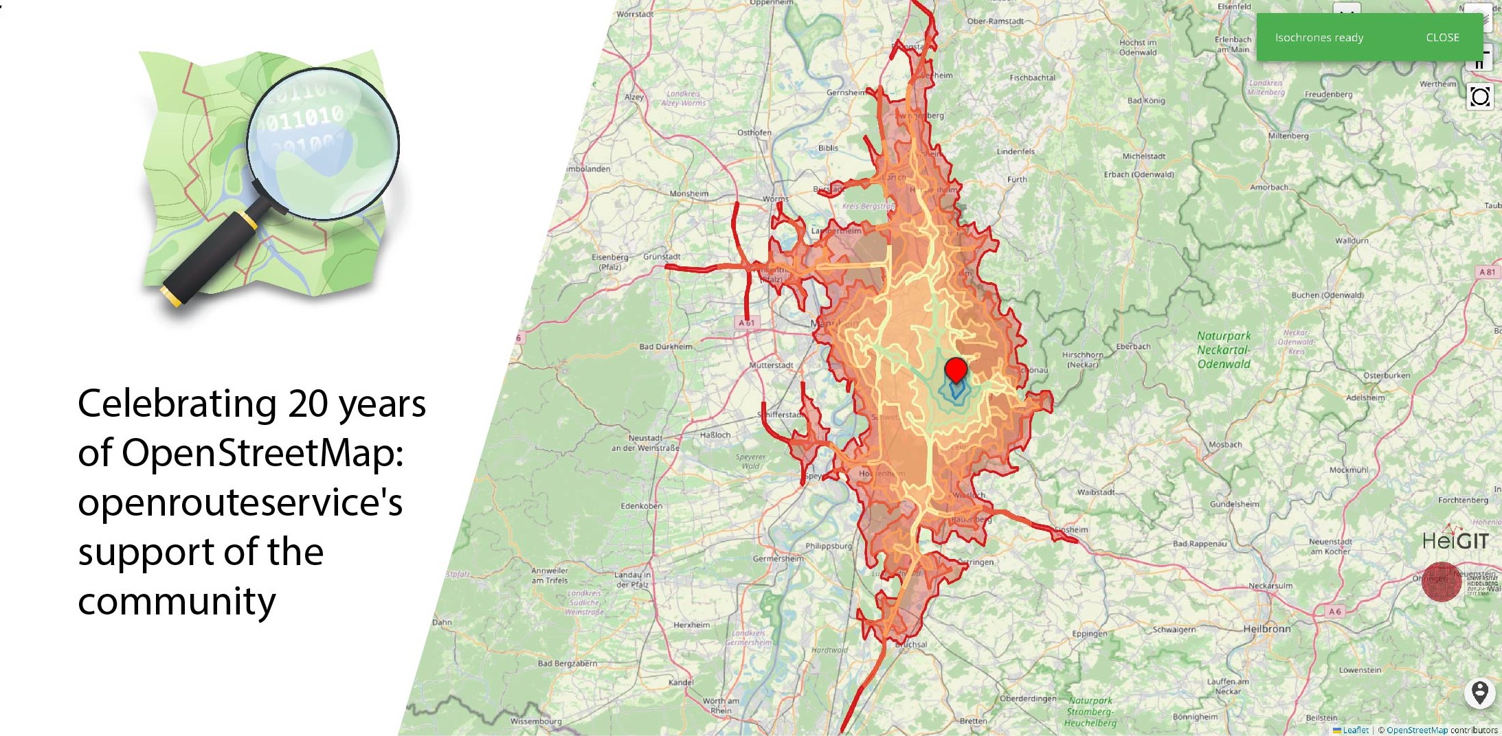
August 9 marks a turning point for the global mapping community: the 20th anniversary of OpenStreetMap (OSM). For two decades, OSM has revolutionized the way we perceive and interact with maps, transforming them from static representations to dynamic, community-driven resources. OpenStreetMap began as a visionary project aimed at creating a free, editable map of the world. What started as a small initiative has grown into a global movement with millions of contributors. These volunteers, rang...| GIScience Blog
Jezdíte rádi na kole? Tak právě pro vás jsem udělal menší srovnání pěti různých online plánovačů cyklovýletů: Mapy.cz, OsmAnd, Strava, Garmin Connect, Cyclers. Každý na to jde trochu jinak a každý vyniká trochu v něčem jiném.| Sesivany's blog
Nos complace anunciar que la Trufi App añadió 25 rutas nuevas con 104 nuevas conexiones! Esto significa que ahora tenemos un total de 120 rutas con 339 conexiones en Cochabamba ...| Trufi App
5 years ago I forked Moritz’s tormap project, updated it a bit and wrote about it. Tormap kept running for years until some changes in googlemaps broke it, not all KMLs were loading as they should. I later on figured out that googlemaps didn’t like that some of the KML files were larger than 3Mb. […] The post Tormap – World map of Tor nodes – 5 years later first appeared on Into.the.Void..| Into.the.Void.