
Hand Drawn Map Video: Isometric Castle Ruin! – Laidback DM: SteveStillStanding.com
Here’s another hand drawn, isometric map of mine – enjoy! :) For more Laidback DM, click here.| Laidback DM: SteveStillStanding.com
Time for a free, old school map! I love drawing maps for Dungeons & Dragons, Pathfinder and Dragonbane adventures. I have far too many, though, so I like to give away my hand-drawn maps when I can. This map comes …| Laidback DM: SteveStillStanding.com
Here’s the third in my latest unplanned mapping series. Enjoy! 🙂 P.S. At some point all these maps will be published in a maps package and with a DM/GM’s workbook, like Ruins of Rukdar-Zin, my latest Kickstarter. What’s that? You …| Laidback DM: SteveStillStanding.com
Why use a map? Imagine a map of your hometown. Seeing that a creek runs along main street or that there are connecting side streets running adjacent to that one highway with the notorious stoplight is the kind of spatial information that could meaningfully impact your life. Now imagine a map of a town you’ve... The post Brain Cartography: Mapping a place that everyone knows, but (almost) no one has ever been appeared first on Stamen.| Stamen
Take a moment to think about the powerful role maps have in our lives. Apart from helping us shape our spatial understanding of the world around us, maps were there for many of our meaningful moments. We used them to navigate a new continent on our first solo trip, to arrive on the doorstep of our dream job or … Continue reading "FINDING YOUR FOOTING"|
The EARTH atlas series is an exclusive limited edition set of atlases with the plates from each atlas being destroyed at the end of the print run. Millennium House (the publisher) had one objective when making the EARTH atlas series. It was quite simply to produce the largest and best atlases in publishing history. EARTH … Continue reading "THE WORLD’S LARGEST ATLAS"|
Gerardus Mercator warped the world to flatten it. He created a conformal map that helped early navigators hold courses of constant bearing across vast oceans.| Galileo Unbound
Correspondent Diederik Van Arkel made a request for more | Rolltop Indigo
I have Strong Opinions on matters of fantasy cartography. No shock, I know! One of those opinions is that you should never draw to fit the paper. The way I fight that tendency (because it can be really hard not to) is I do a lot of preliminary work on a much, much larger canvas than the target output.| Rolltop Indigo
The main "poster" map of Hammondal is complete. It'll still evolve as the book progresses, of course, but it's nice to see it all together ... or even pointedly dissected.| Rolltop Indigo
The Hammondal poster townmap is nearly done. What's preventing it from being declared a "complete draft" is boats. I've done multiple passes at "populating" the city's harbor and other waterlines with ships and boats, and each one has fallen short of my standards in one way or another. I'll keep poking at it between fontwork and other stuff. I hope to begin some of the building interior maps over the next week, and I'm excited for those! The obligatory spray of development snapshots follows, ...| Rolltop Indigo
Last month, I led an interactive workshop at The Midwest Climate Adaptation Science Center’s Summer Symposium at the University of Illinois Urbana-Champaign in Urbana, Illinois. MW CASC is a consortium of research-focused academic, Tribal, and non-profit partners working collaboratively with the United States Geological Survey (USGS). The workshop focused on data visualization and mapping for... The post Data visualization and mapping for a scientific audience with USGS Midwest Climate Ad...| Stamen
Here’s another hand drawn, isometric map of mine – enjoy! :) For more Laidback DM, click here.| Laidback DM: SteveStillStanding.com

Hi all – here’s another of my impromptu hand drawn dungeon maps. This one is mountain lair filled with technological stuff. Enjoy! :) For more Laidback DM, click here.| Laidback DM: SteveStillStanding.com

C heck out another of my hand drawn maps on YouTube! Enjoy! :) For more Laidback DM, click here.| Laidback DM: SteveStillStanding.com

Earlier this summer, Stamen collaborated with the team at MetroMatch to update the look and feel of their transit-first navigation tool. MetroMatch is a transit-focused travel planning and discovery site that connects travelers to destinations that are only a short walk from rail stations. MetroMatch’s pilot focuses on Washington, DC, taking advantage of the region’s...| Stamen
A personal history of OpenStreetMap, seen through the eyes of Stamen Design by Alan McConchie and the Stamen Design team Recap Back in 2021, we wrote a two-part blog post about the history of Stamen Design and OpenStreetMap (“OSM” for short), and the twists and turns of Stamen’s close relationship with the OSM project over...| Stamen

Check out another hand drawn map video! Enjoy :) For more Laidback DM, click here.| Laidback DM: SteveStillStanding.com
The State of the Map US (SOTMUS) 2025 conference in Boston, MA was yet another fantastic gathering of cartographers, mappers, and map enthusiasts. Stamen was well-represented this year by Kelsey Taylor, Eric Brelsford, and Eric Rodenbeck. We presented two talks on Stamen projects related to open source tooling with maps. Now that we’re back in...| Stamen
Stamen is officially retiring Map Stack, a platform we previously hosted that gave everyone a straightforward way to mix and modify raster base maps. What was Map Stack? Created in 2013, Map Stack gave you an interface where you could select from a variety of raster base maps, tweak the images that made up the...| Stamen

I love maps. You probably guessed that lol. Here’s my take on a sinister tree dungeon… Enjoy! :) For more Laidback DM, click here.| Laidback DM: SteveStillStanding.com

Like maps? of course you do – you wouldn’t have clicked on this otherwise lol! Enjoy :) For more Laidback DM, click here.| Laidback DM: SteveStillStanding.com
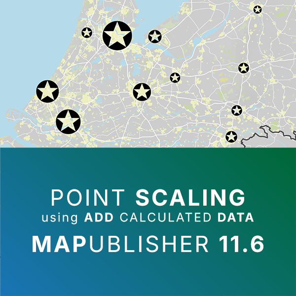
Check out our latest video showcasing how the new Point Scaling feature works in MAPublisher 11.6 using the Add Calculated Data tool!| Avenza Systems Inc.

In vector cartography, the map is only as good as the data that powers it. If we don’t understand what’s going on in the underlying data, we’re pretty limited in our cartographic approach. A major part of this work involves parsing vector tile data, determining how one dataset compares to another, and diagnosing bugs encountered...| Stamen

This scary tower is the home of the Wizard Lich Azekai – enjoy! :) For more Laidback DM, click here.| Laidback DM: SteveStillStanding.com

Another map? When will it end? Hopefully, never lol. Enjoy :) For more Laidback DM, click here.| Laidback DM: SteveStillStanding.com

Another of my hand drawn maps from YouTube! Enjoy! :) For more Laidback DM, click here.| Laidback DM: SteveStillStanding.com
Invasion is a film by Hugo Santiago, written with Borges and Bioy Casares. The plot takes place in the city of Aquilea, a chimerical construction made of parts of Buenos Aires. In the film the city is the scene of resistance to the invaders, reflecting the Argentine socio-political context of the time. L’article Invasion (1969), the chimeric Buenos Aires est apparu en premier sur Senses Atlas.| Senses Atlas

(or actually they do, but they don’t use this knowledge effectively)Update, April 26, 2025: the address fix for W 6th Ave is live, mostly. Going forward I wish that Google Maps would make it harder…| Random ASCII - tech blog of Bruce Dawson

Skopje’s architectural landscape is far from modest. It is no surprise that its location in the heart of the Balkans manifested a confluence of various timelines existing adjacent to one another. W…| VOICES

And here’s the final map in the three-part series, along with a video showing all the maps put together! Cheers :) For more Laidback DM, click here.| Laidback DM: SteveStillStanding.com

Here’s part 2 of 3 of the map timelapses for the Krakeni Outpost. Enjoy :) For more Laidback DM, click here.| Laidback DM: SteveStillStanding.com

Here’s a new hand drawn map timelapse on YouTube. This is part one of three. Enjoy! :) For more Laidback DM, click here.| Laidback DM: SteveStillStanding.com

In the early 18th century, Holy Roman Emperor Charles VI charged Johann Christoph Müller to produce an “authentic and complete” map of the kingdom of Bohemia. Being no slouch, Müller…| K. M. Alexander
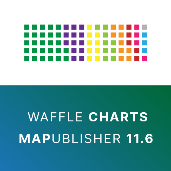
Check out our latest video showcasing how to create waffle charts, a chart type newly added to MAPublisher 11.6!| Avenza Systems Inc.
The ”Napoleon Map“ by the French engineer Charles-Joseph Minard is one of the most cited works of data visualization. Unfortunately, it is still highly relevant|
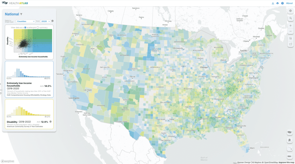
Stamen has been working with a team out of UCSF (University of San Francisco) Population Health and Health Equity to create and maintain their Health Atlas since 2019. You can read a bit about the initial launch in our blog post from 2020. In 2024 we had the opportunity to rebuild the Health Atlas and...| Stamen
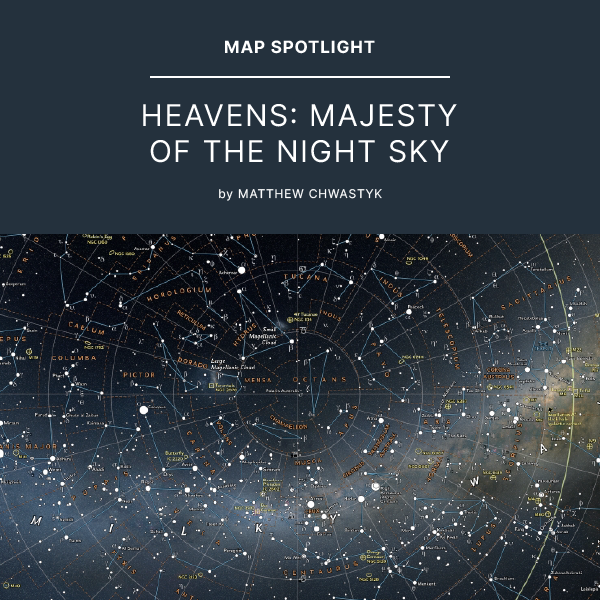
This Map Spotlight showcases an honourable mention of the 2021 Avenza Map Contest: Yedoma Permafrost Coverage by Sebastian Laboor.| Avenza Systems Inc.
A short post today about the QGIS YouTube channel I just launched: called Map Academy. I have my Udemy courses online, and these are aimed at people who want a fully-fledged end-to-end QGIS course at intro or intermediate level. The Udemy courses are going pretty well and I have more than 6,000 students in 148 countries so far - with the top countries being the US, India, the UK, Germany, Canada, Nigeria, Turkey, Indonesia, Egypt and Brazil. If you want to request a video on my new YouTube ch...| Stats, Maps n Pix
This post contains a few GIS related thoughts, offered in the spirit of sharing that's at the core of open source. A bit like QGIS itself, I hope. My goal is not to convince anyone that they should be using QGIS but rather to convince potential GIS users that QGIS is now, at 21 years old, a mature, robust, powerful product used by millions of users and thousands of major corporations and universities worldwide - as well as lots of small companies like my own. | Stats, Maps n Pix
Many people who read this blog will be familiar with Karim Douïeb's fantastic 'transition between surface area of US counties and their associated population' map, shown below.| Stats, Maps n Pix
This is a short tutorial about how to display label callouts (sometimes referred to as 'leader lines') in QGIS. This has been possible for a while, but not everyone knows it's possible, or how to do it. So long as you're using QGIS version 3.10 or later, you create callouts for your labels very easily. Before going any further, here's an example of a map where label callouts would be useful (below). And here's the map layer I'm using for this tutorial, in case you want to follow along with th...| Stats, Maps n Pix
In one of my many 'playing around with map stuff and then posting it on twitter' adventures, I recently posted a kind of comet map - see below. This started off as something completely different but once I had the basic idea I then wondered what kind of data I could apply it to, and that's why I did it to the UK political map of 2019. Read on below for how I did it, as well as how you can replicate it pretty easily in QGIS. Scroll straight to the bottom if you're just looking for the 'how-to'...| Stats, Maps n Pix
This story begins one day when I was assembling a map of the city of Edmonton, Alberta from OpenStreetMap data. It was going to be a big map, a 42″ (106 cm) wide poster for a wall. The data was good, but the standard OSM colours were not. They would work fine for a street … Continue reading Cartographic palettes and colour harmonies→| The Wandering Cartographer
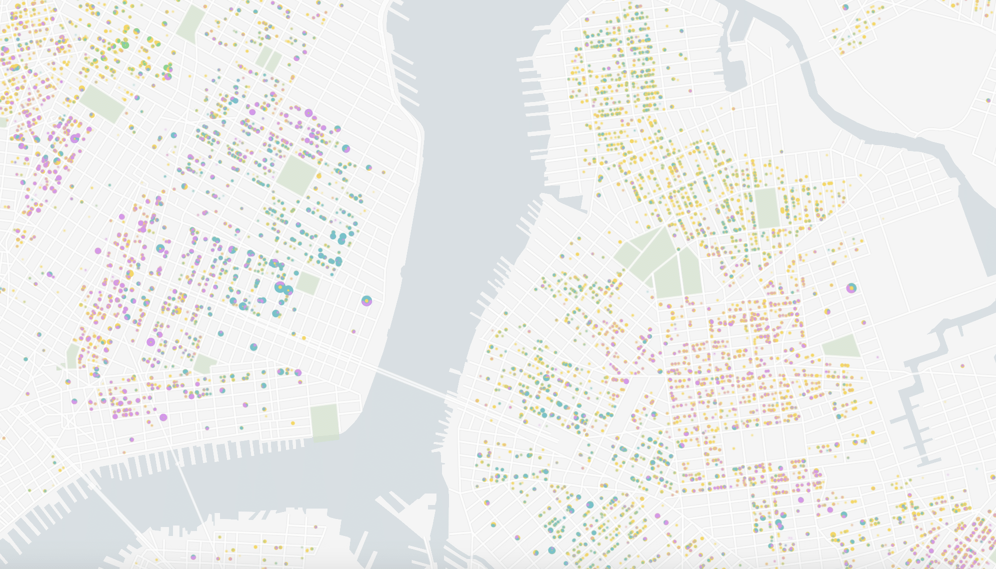
Content in this post comes from our presentation at the North American Cartographic Information Society (NACIS) 2024 Annual Meeting last week in Tacoma, WA. Mapping Historical New York: A Digital Atlas visualizes New York City’s transformations during the late-nineteenth and early-twentieth centuries both in terms of population and landscape. Drawing on 1850, 1880, 1910, and...| Stamen

If you’ve been reading this blog for any length of time, you’ll know that maps and history are two of my favorite things. I love history because I love learning about the vast panoply of the human …| Goldwag's Journal on Civilization
© www.viewsoftheworld.net Waldo Tobler is dead. He is most remembered for his affable manner, his very kindly smile, the remarkable longevity of this academic life, his great academic achievements and – much more importantly – for being very kind, especially to strangers. … Continue reading → The post Remembering Waldo Tobler was written by Benjamin Hennig and published on Views of the World. If you enjoyed this, you might want to follow me on Twitter or Facebook. - publication on o...| Views of the World
© www.viewsoftheworld.net Mining may have been one contributing factors to why Australia as one of the few advanced economies did not go into recession following the global financial crisis 10 years ago. While mining is a profitable business in Australia, once the … Continue reading → The post The Holey Land: Abandoned Mines in Queensland / Australia was written by Benjamin Hennig and published on Views of the World. If you enjoyed this, you might want to follow me on Twitter or Facebook...| Views of the World
© www.viewsoftheworld.net There is a new map in town! Earlier this month during the 125th Anniversary Conference of the Geographical Association in Sheffield (UK) we relaunched the new Worldmapper.org online platform which has been several years in the making. It is not … Continue reading → The post Worldmapper: The Relaunch was written by Benjamin Hennig and published on Views of the World. If you enjoyed this, you might want to follow me on Twitter or Facebook. - publication on other w...| Views of the World
Filling the Sandbox| Nagora's Corner

If you’ve been reading this blog for any length of time, you’ll know that maps and history are two of my favorite things. I love history because I love learning about the vast panoply of the human …| Goldwag's Journal on Civilization
Cartography Series: Because who doesn’t love looking at old maps? This blog series looks at the cartographic development of Canada. Carte Physique des Terreins les plus élevés de la Partie Occidentale du Canada (Physical map of the highest elevations in the Western part of Canada) by Philippe Buache (1754). *Blows dust off Cartography series.* It … Continue reading Two Maps in One: Philippe Buache on Western Canada| All About Canadian History
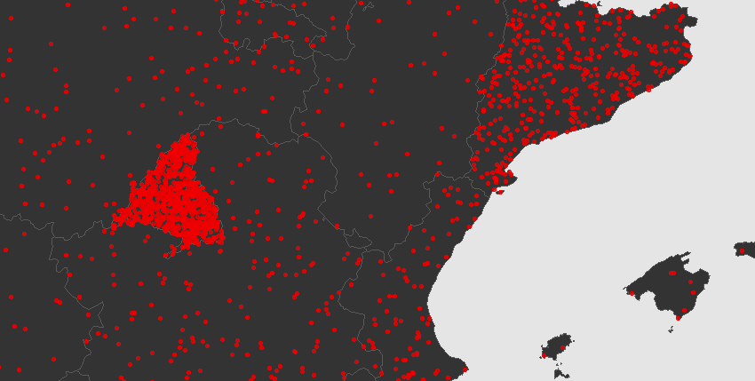
Tracking the outbreak in Spain by region - Visit the microsite with maps and official data on the impact of...| One world | Projects, maps and coding
Vignette of the package expansion - Introduction| One world | Projects, maps and coding
A solution for b/w and academic maps. - Updated 17 february 2020: All these pieces of work are already available...| One world | Projects, maps and coding
A choropleth map with R - This is a quick post on how to create a map as per the...| One world | Projects, maps and coding

During exploitation of ELF binaries, it is quite common that one needs to find a writable memory region: a writable “cave”. In this post I’ll present two generic techniques to fin…| Eyal Itkin

In the previous post I demonstrated how to bypass Microsoft’s RFG, a.k.a. “Shadow Stack”, assuming we can locate the shadow stack. In this post I’ll fill up the missing deta…| Eyal Itkin

At the end of 2016, while checking for updates in Microsoft’s bounty program, I saw a reference to a new defense mechanism called “Return Flow Guard” (RFG). Since at that time I j…| Eyal Itkin

A mix of design style guides, map making tutorials and machine learning research| MORPHOCODE
