
Complete Guide: Inheritance strategies with JPA and Hibernate
Hibernate and JPA support 4 inheritance strategies which map the entities to different table models. But which one is the best for your use case?| Thorben Janssen
A new wind map covering the whole of Mars includes some of the fastest winds ever detected on the Red Planet.| Eos
Hibernate and JPA support 4 inheritance strategies which map the entities to different table models. But which one is the best for your use case?| Thorben Janssen
By Martin Moss, Senior Officer - Green Infrastructure Mapping Team As recognition grows of the importance of nature to our health and wellbeing, understanding green infrastructure provision is vital to ensuring everyone can benefit from nature wherever they live. Natural …| Natural England
We’re in the middle of a step change for national-scale environmental evidence in England. In recent years, the Natural Capital and Ecosystem Assessment (NCEA) programme has allowed us to create and upgrade maps and data products like the England Peat …| Natural England
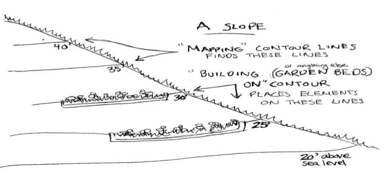
Learn how to use keylines and contour to work with the slope of the land.| Permaculture Womens Guild
Erstmals liegt ein systematischer Überblick über Forschungs- und Praxisprojekte in Deutschland vor. Was an den Ergebnisse überrascht und warum wir dringend bessere Daten brauchen, erklären Justus Henke, Lars Reinelt und Lisa Mertin im Gastbeitrag. Berlin: 25 Wissenschaftskommunikationsprojekte. Bremen: 15 Projekte. Greifswald: 1 Projekt. Diese Zahlen aus dem ersten systematischen Mapping der deutschen Wissenschaftskommunikation erzählen eine […]| Wissenschaftskommunikation.de
Open data and citizen-driven mapping are create digital transport maps that enable inclusive mobility in Mexican cities. The post Trufi and Partners: Enabling Inclusive Mobility Through Open Data appeared first on Trufi Association.| Trufi Association
At HiiKER, we’ve been on a mission for the past four years: to help people plan and navigate their hikes through some of the world’s most beautiful wilderness. Along the way, one thing has become […]| HiiKER
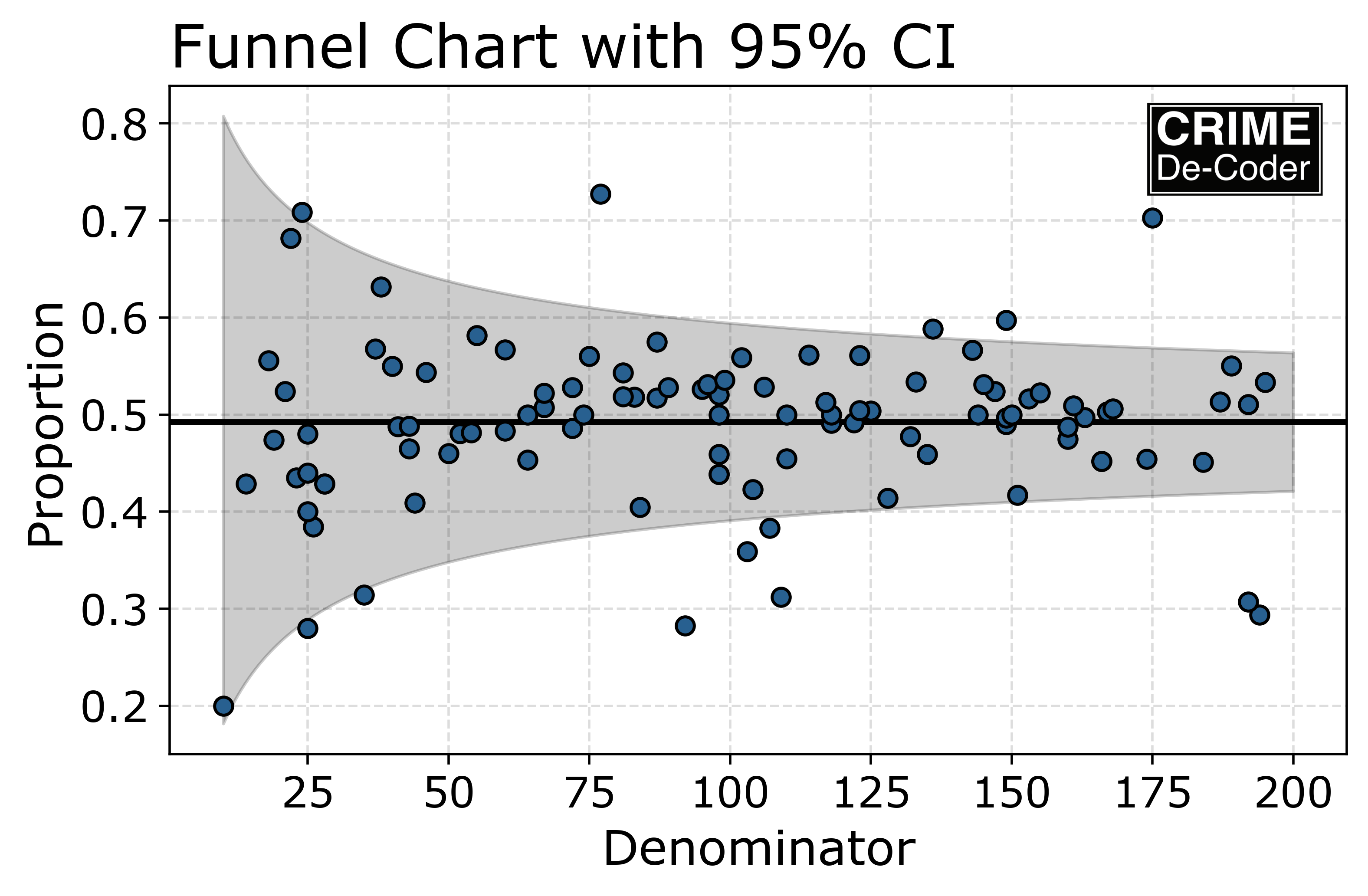
For some housekeeping, if you are not signed up, also make sure to sign up for the RSS feed of my crime de-coder blog. I have not been cross posting here consistently. For the last few posts: Using…| Andrew Wheeler
The post Hibernate Performance Tuning – 2025 Edition appeared first on Thorben Janssen. Based on most discussions online and at conferences, there seem to be 2 kinds of projects that use Hibernate for their persistence layer: So, what’s the difference between these projects? Are the projects in the 2nd group more complex or have higher performance requirements? No, based on my consulting projects, that’s not the case. On... The post Hibernate Performance Tuning – 2025 Edition appeared...| Thorben Janssen
The post Date and Time Mappings with Hibernate and JPA appeared first on Thorben Janssen. Databases support various data types to store date and time information. The most commonly used ones are: You can map all of them with JPA and Hibernate. But you need to decide to which Java type you want to map your database column. The Java language supports a bunch of classes to represent date and... The post Date and Time Mappings with Hibernate and JPA appeared first on Thorben Janssen.| Thorben Janssen
At Our Towns, we’ve been following the tools and applications of geospatial information systems (GIS), as they have progressed from promise to delivery. GIS helps in countless ways: for cities… The post How Story Maps Drive Progress appeared first on Our Towns.| Our Towns

Note, this is only available on Android… coming to iPhone app very soon! Get ready for some fantastic updates to your HiiKER app! Say hello to Points of Interest (POIs) and super handy Quick …| HiiKER
Help send Colombia’s Duitama Mapping Stars to State of the Map LATAM 2025. Support the students behind many of our transport data projects across the globe. The post Send Our Young Mapping Stars to State of the Map LATAM appeared first on Trufi Association.| Trufi Association

Be like Anahi: Volunteer for Trufi! This urban planner-turned-coder fixes transit routes and inspires mappers worldwide. Could you be next?| Trufi Association

The European Commission JRC recently released a new 2023 update of the Global Human Settlement Layer (GHSL) data. This update has greatly improved the GHSL data, with a 10 metre scale built-up area…| CityGeographics
We’ve been working to expand the directory to cover 8 new boroughs in West London and we've managed to add 147 businesses to the directory! The post The Repair Directory now has 300 listings following our West London expansion! appeared first on The Restart Project.| The Restart Project Blog
"Repair is Essential" - this is the theme we chose for this year's International Repair Day. In London, an online team of volunteers mapped 45+ repair businesses in London to be considered for inclusion. Small groups met repair businesses in Crystal Palace, Shepherd's Bush and Tooting. The post Repair is essential! Here is how we celebrated International Repair Day appeared first on The Restart Project.| The Restart Project Blog
The Repair Directory lists reliable repair businesses in London. We are asking the public to submit their favourite London repair shops! The post Help us expand the Repair Directory across London appeared first on The Restart Project.| The Restart Project Blog
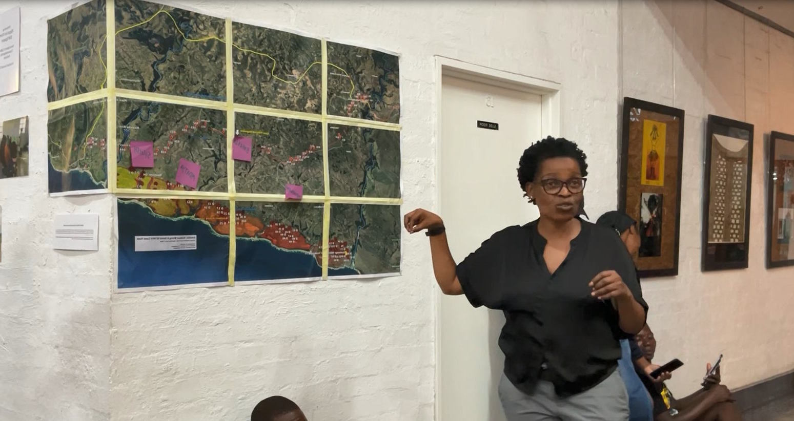
A new series of maps shows the values and visions for land in Xolobeni, South Africa, in contrast to top-down 'development' plans.| Future Natures

ViewRanger is still talked about to this day when it comes to hiking, mapping and navigation technology. Like us, you might be still mourning the removal of ViewRanger from the app store.ViewRanger…| HiiKER

How to use database sequences, tables and auto-incremented columns to generate primary key values with JPA and Hibernate.| Thorben Janssen

NASA announced that it has selected a proposal led by Planetary Science Institute Research Scientist Kirby Runyon to train hundreds of citizen scientists to map the Moon in high resolution.| Planetary Science Institute
In the ever-evolving world of hiking and hillwalking, technology continues to push the boundaries of what’s possible. HiiKER offers real-time navigation, route planning, and more essential tools for adventurers. However, even with the latest in […]| HiiKER
After 5 exhilarating years at Tableau on December 29th, I said my goodbyes and walked out of the Seattle offices for the last time. Tableau was a great learning experience for me. Watching the company grow nearly 7 fold, going through an IPO and becoming the gold standard for business intelligence… I worked with very […]| Bora Beran
Creating graphics, videos or social media posts? Here are some tools that can help. The post Graphics | Video | Social appeared first on SPJ Toolbox.| SPJ Toolbox

Recently for a crimede-coder project I have been building out a custom library to make nice leaflet maps using the python folium library. See the example I have posted on my website. Below is a scr…| Andrew Wheeler
Transportation Troubleshooting: How Drone Technology Is Adding New Perspectives to Transportation| informedinfrastructure.com

Each year CASA master’s students demonstrate their spatial data visualisation skills with a group project. The theme this year was ‘Urban Futures’, and students have produced some very impres…| CityGeographics

We're diving deep into the world of Simon's Wardley Mapping. In this post, we’ll explore the key points and insights covering the evolution of this| The Serverless Edge

Easily map LocalDateTime, ZonedDateTime, and other Date and Time API classes with Hibernate. Here's everything you need to know| Thorben Janssen
Unwrapping Christmas Gifts This is my last post on “The Autonomy of Affect” and I expect to go onto the rest of the book. Near the end Massumi makes a fantastic point about the somewhat false problem of transcendence vs. immanence, something that he also perceptively links to our spatializaton of concepts, and to his own prescription […]| Frames /sing
How can you join your non-spatial data to spatial data? Using the latest spatial functions, you can achieve spatial joins in Tableau with almost any data source. The post Spatial Joins in Tableau with Excel, Text, Anything appeared first on VizPainter.| VizPainter

FetchTypes define when Hibernate shall fetch associated entities from the database and are an important element for a high-performance persistence layer.| Thorben Janssen
I have recently started using a OSX installed macbook pro work for my work. It is a performance beast but the main environment I'm used to up to this point was Windows. I had a hard time getting used to the key layout, especially...| Ali Naci Erdem Personal Blog RSS

Although Greater London has an extensive transit network, this is not the case for many UK cities where underinvestment and privatisation has seen bus, metro and rail networks stagnate in recent de…| CityGeographics
Sectors are the uncontrolled influences that we have to consider in our permaculture sector analysis and designs. Here's how and why to map them.| Free Permaculture

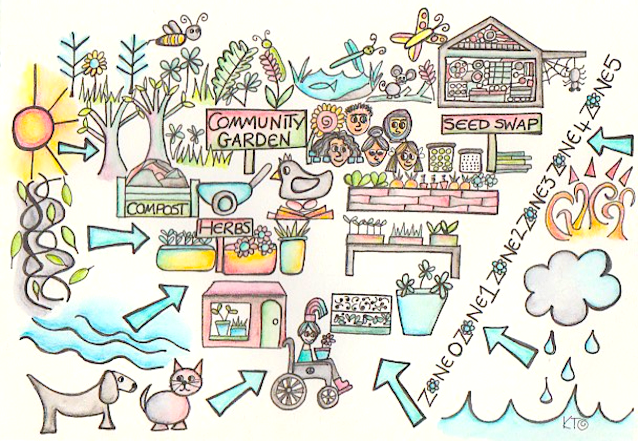
Permaculture zones help us organize our spaces according to how (and how often) we use them| Free Permaculture
Drohnen sind zu einem wichtigen Werkzeug in der Vermessung geworden. Noch kommen die Ergebnisse in Form georeferenzierter Karten oder 3D-Modelle nicht ganz an die Genauigkeit heran, die mit herkömmlichen Instrumenten wie Tachymeter oder Theodolit erreicht wird. Für viele Anwendungszwecke genügt aber die erreichbare Auflösung. Die Geschwindigkeit, mit der auch größere Flächen erfasst werden können ist auf jeden Fall ein gewichtiges Argument für die Drohnenvermessung. Der typische Work...| dirkkoller.de
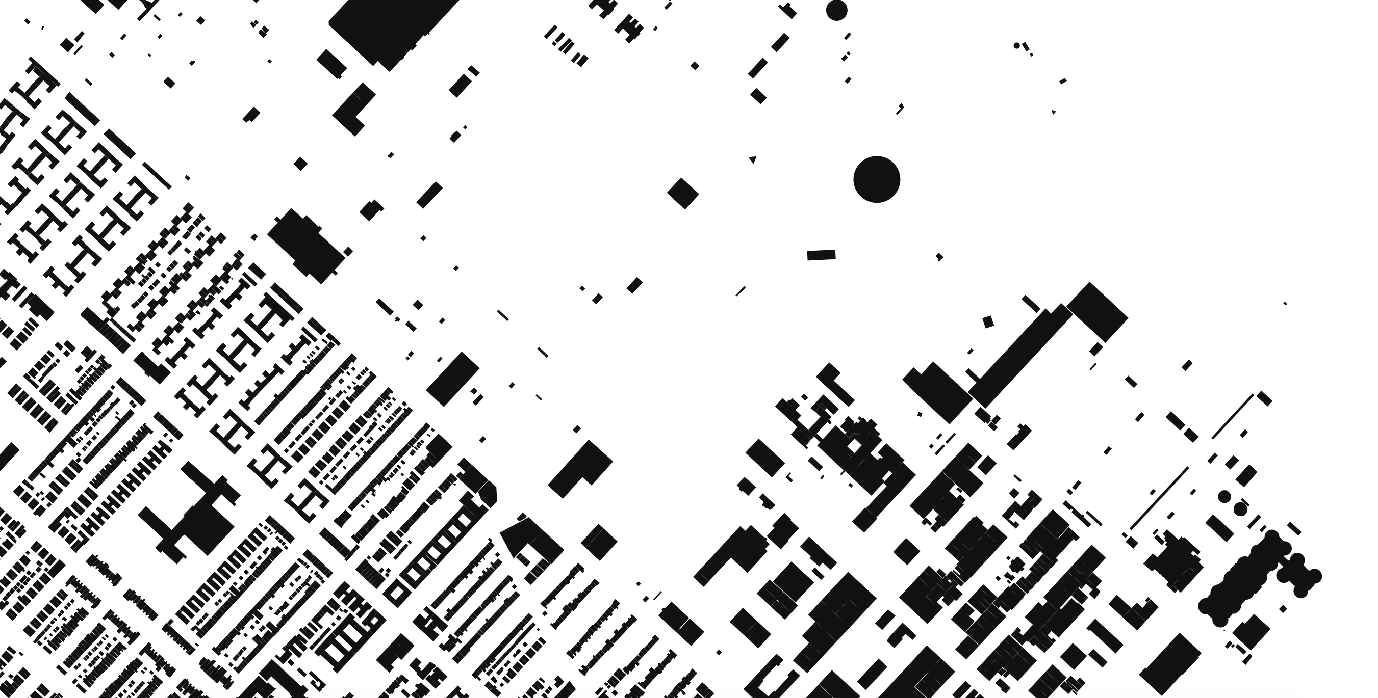
A figure-ground diagram is a mapping technique used to illustrate the relationship between built and unbuilt space in cities.| MORPHOCODE

The housing crisis in London has become increasingly severe in the last decade with much higher prices, rents, and largely static incomes, while housing development volumes have remained consistent…| CityGeographics

You should know the basic elements of Wardley Mapping for strategy.| Dave's Research Co.
The eyeo festival and the community around it has a very special place in my heart. When Dave Schroeder announced the team was editing a book to celebrate the fifth anniversary, my immediate thought was to use this opportunity to follow up on an old idea, which I had been kicking around for a while (also with a few friends) — mapping the community around this arts-tech-creative-code-datavis thing. | Well-formed data

The Office for National Statistics have started to publish the more detailed tables from the new 2021 census. Of particular interest for my research are the variables related to gentrification. In …| CityGeographics
A really cool, recent question on Stack Overflow was about how to map a nested collection into a Java Map with jOOQ. In the past, I’ve blogged about the powerful MULTISET operator many times,…| Java, SQL and jOOQ.

Hibernate 6 introduced a huge improvement to the mapping of ZonedDateTime and OffsetDateTime.| Thorben Janssen

Hibernate 6 introduces support for records as embeddables. In 6.0 and 6.1, this still requires a custom instantiator. Starting with 6.2, Hibernate handles it automatically.| Thorben Janssen

PostgreSQL offers proprietary datatypes to store JSON documents which are not supported by Hibernate. But you can change that with a UserType.| Thorben Janssen
