Interview: Mikhail Kuzin: OSMPIE
In this month’s edition of our OpenStreetMap interview series we speak with Mikhail Kuzin, one of the makers of OpenStreetMap editor OSMPIE| blog.opencagedata.com
In this month’s edition of our OpenStreetMap interview series we speak with Mikhail Kuzin, one of the makers of OpenStreetMap editor OSMPIE| blog.opencagedata.com
Si avvicina State of the Map Europe 2025, il convegno dedicato alla comunità OpenStreetMap e al mondo dei dati geografici liberi e collaborativi in Europa, che si terrà il 14 e 15 […]| Wikimedia Italia
The conference brings together experts, developers, and enthusiasts of open data for two days of talks, workshops, and discussions. HeiGIT will contribute with several different sessions covering a range of topics. “Goodbye OSHDB – Welcome ohsomeDB!” – Benjamin Herfort Friday, November 14, 11:00 AM We will introduce ohsomeDB, the new successor of the OpenStreetMap History […]| GIScience Blog
Together with the German Federal Agency for Cartography and Geodesy (BKG) we released a new version of the ohsome dashboard, introducing a new indicator for assessing the thematic accuracy of land cover data in OpenStreetMap (OSM). This development is part of a broader project together with BKG on OSM data quality evaluation. New indicator: Thematic […]| GIScience Blog
We interview Raphael de Assis, president of UMBRAOSM about Mapeia Brasil| OpenCage Blog
We interview Thibaut Maïto, a member of the OpenStreetMap communit in Lyon, France about the pleasures of mapping in the region| OpenCage Blog
Il 21 settembre scorso si è svolta la Trento Mapathon 2025, un evento dedicato alla raccolta e all’aggiornamento di dati territoriali tramite attività di mappatura dal vivo su OpenStreetMap. Tanti nuovi […]| Wikimedia Italia
Dal mese di aprile 2025, la comunità italiana di OpenStreetMap ha portato avanti iniziative mensili di miglioramento mirato dei dati geografici. Ogni mese, i membri hanno proposto diversi […]| Wikimedia Italia
Together with the German Federal Agency for Cartography and Geodesy (BKG) we released a new version of the ohsome dashboard, introducing a new indicator for assessing the thematic accuracy of land cover data in OpenStreetMap (OSM). This development is part of a broader project together with BKG on OSM data quality evaluation. New indicator: Thematic […]| HeiGIT
The ENHANCE project explores how 15-minute city principles can be applied beyond dense urban hubs, using mapping, behavioral research, and simulation tools to design more sustainable and inclusive mobility systems. The ENHANCE project, funded by Driving Urban Transitions to a Sustainable Future (DUT) under JPI Urban Europe, addresses the challenges of implementing 15-minute city (15mC) […]| HeiGIT
State of the Map World is the annual event for all mappers and OpenStreetMap users. The program consists of talks, workshops, discussion rounds and more. HeiGIT is taking part with three different contributions. ORS-Tools – Beginner-friendly Mobility Analysis with OpenStreetMap and openrouteservice in QGIS – Julian Psotta, Benjamin Herfort Friday, 11:30 (60 minutes (plus Q&A)); Room: […]| GIScience Blog
We interview Dustin Carlino about his new business A/B Street| OpenCage Blog
After a bit of a summer hiatus our OpenStreetMap interview series is back!| blog.opencagedata.com
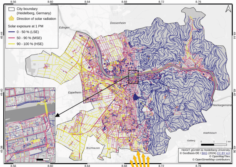
Using Heidelberg as a case study, researchers modeled time-dependent solar exposure for the entire pedestrian network by combining high-resolution DEM/DSM building and vegetation data with OpenStreetMap road data.| HeiGIT

Using Heidelberg as a case study, researchers modeled time-dependent solar exposure for the entire pedestrian network by combining high-resolution DEM/DSM building and vegetation data with OpenStreetMap road data.| GIScience Blog

Sabato 20 settembre 2025 si terrà a Parma il Wikiraduno con editathon e mapping party presso Casa nel Parco - Officine On/Off.| Wikimedia Italia
Open data and citizen-driven mapping are create digital transport maps that enable inclusive mobility in Mexican cities. The post Trufi and Partners: Enabling Inclusive Mobility Through Open Data appeared first on Trufi Association.| Trufi Association
A VIP visit to Duitama highlighted the successes of our team, our app, and the work yet to be done for rural mobility.| Trufi Association
Volunteered Geographic Information (VGI) is a valuable resource for an effective disaster management. This article presents five free tools to enhance humanitarian work using VGI. What is VGI and why it matters for disaster management Volunteered Geographic Information (VGI) refers to user-generated geographic content contributed voluntarily by the public. It represents a form of crowdsourcing […]| HeiGIT
This blog post introduces a step-by-step tutorial for working with a global road surface dataset. Using open-source tools, the tutorial demonstrates how to identify infrastructure gaps by combining road surface data with population information. How much time does a humanitarian mission need to reach a remote village after a cyclone hits rural Madagascar? How fast […]| HeiGIT

A personal history of OpenStreetMap, seen through the eyes of Stamen Design by Alan McConchie and the Stamen Design team Recap Back in 2021, we wrote a two-part blog post about the history of Stamen Design and OpenStreetMap (“OSM” for short), and the twists and turns of Stamen’s close relationship with the OSM project over...| Stamen
On January 24, 2010, Zeke Farwell completed the Long Trail. He had begun just two days earlier, connecting more than 50 segments of trail spanning over 200 miles. Motivated by “the longest and most well known hiking trail in Vermont”, Zeke often revisited portions of the trails in the years to come. Now I’m not revealing a secret FKT, but rather the completion of the Long Trail route on OpenStreetMap. OpenStreetMap is like Wikipedia …| Satoshi Village
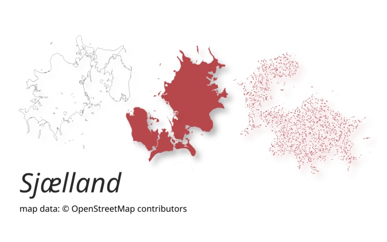
A new version of ohsome-planet (codename “Sjælland”) has been released. It is the newest version of HeiGIT´s command line tool, which transforms OpenStreetMap (history) PBF files into into an analysis-ready data format. We illustrate what ohsome-planet can do by assessing how many OSM edits used Bing Imagery as reference source.| GIScience Blog
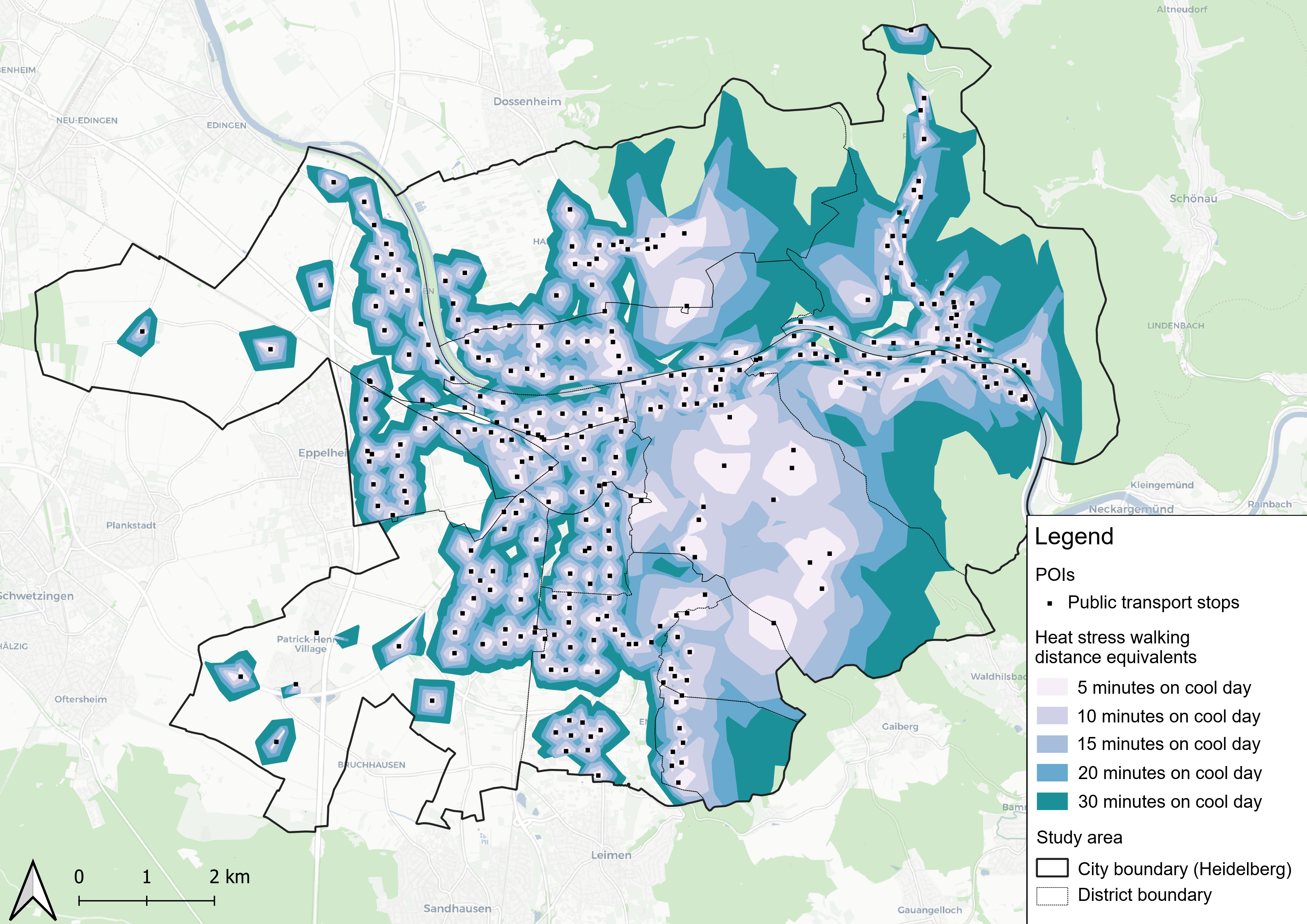
This study introduces the isocalor approach to assess how solar exposure and heat stress impact pedestrian access to essential services in Heidelberg, using OpenStreetMap data and a customized openrouteservice routing engine.| GIScience Blog
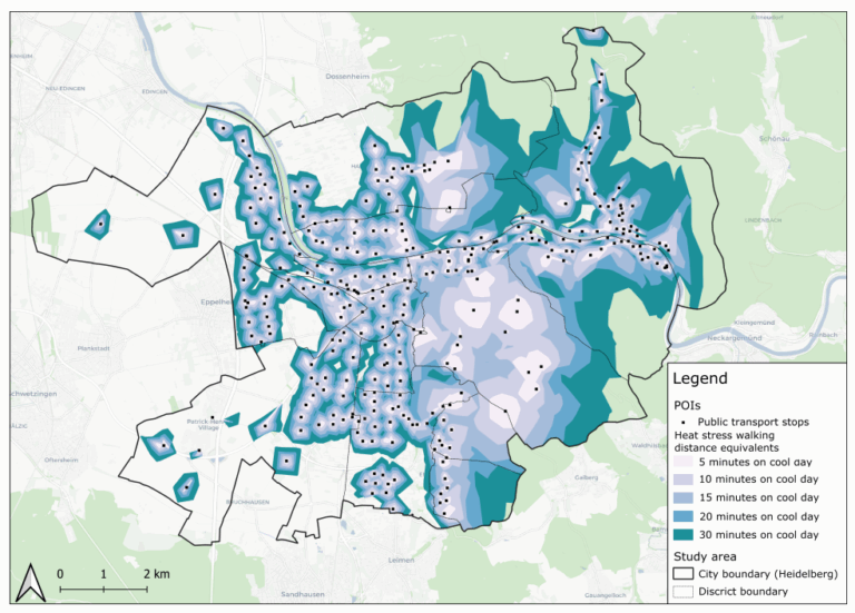
This study introduces the isocalor approach to assess how solar exposure and heat stress impact pedestrian access to essential services in Heidelberg, using OpenStreetMap data and a customized openrouteservice routing engine.| HeiGIT

This project explores how OpenStreetMap data can complement satellite imagery for tracking land cover changes in Germany. Using a small test area, we compare datasets over time to better understand how real-world changes are reflected in OSM—and how this knowledge can support automated monitoring.| HeiGIT
Grassroots mapping makes invisible transport systems visible. See Oaxaca volunteers collect route data to advocate for better public transit options.| Trufi Association
This study, published at African Transport Studies, investigates the impact of school sessions on traffic congestion in Nairobi, highlighting how children’s mobility needs are often overlooked in transport planning.| HeiGIT
Help send Colombia’s Duitama Mapping Stars to State of the Map LATAM 2025. Support the students behind many of our transport data projects across the globe. The post Send Our Young Mapping Stars to State of the Map LATAM appeared first on Trufi Association.| Trufi Association

Transport justice can’t arrive with closed data. What the evolution of everyday tech reveals about the power of sharing information.| Trufi Association
We’re excited to share the release of the ohsome-planet – a new software library on GitHub, marking a significant step toward the development of ohsome 2.0. This tool is designed to facilitate the transformation of raw OpenStreetMap (OSM) history data into the GeoParquet format, making it more accessible and efficient for spatial data analysis.| GIScience Blog
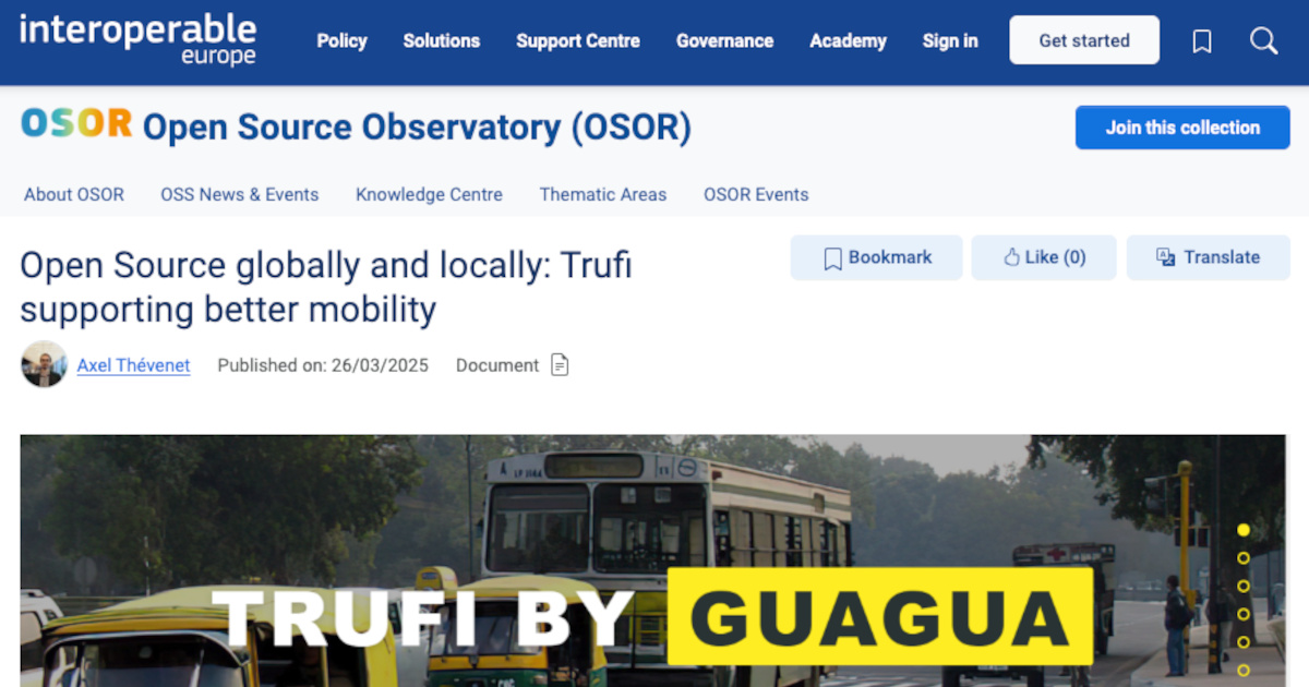
OSOR recognizes Trufi for advancing open-source public transport solutions, built on OpenStreetMap and global collaboration.| Trufi Association

An article from last year’s Perl Advent Calendar gave me an idea. As is often the case, that idea spawned other ideas. One of those new ideas raised the question: “How do I get all tram lines and tram stops in Hannover, Germany from OpenStreetMap?”. Here’s my answer to that question, implemented–because reasons–in Python.| P.T.C.

Collaborative mapping and open data are enhancing urban transport planning in Oaxaca, Toluca, and beyond - the TranSIT initiative in Mexico| Trufi Association
You may have seen this toot announcing OpenStreetMap's migration to Debian on their infrastructure. 🚀 After 18 years on Ubuntu, we've upgraded the @openstreetmap servers to Debian 12 (Bookworm). 🌍 openstreetmap.org is now faster using Ruby 3.1. Onward to new mapping adventures! Thank you to the team for the smooth transition. #OpenStreetMap#Debian 🤓 We spoke with Grant Slater, the Senior Site Reliability Engineer for the OpenStreetMap Foundation. Grant shares: Why did you choose Debi...| Bits from Debian
It all started with the following statement: "my renders are too slow". There were three issues as the root case: osm-carto had become more complex (nothing I can do there), my compute resources were| .:: Marcos Dione/StyXman's glob ::.

Jezdíte rádi na kole? Tak právě pro vás jsem udělal menší srovnání pěti různých online plánovačů cyklovýletů: Mapy.cz, OsmAnd, Strava, Garmin Connect, Cyclers. Každý na to jde trochu jinak a každý vyniká trochu v něčem jiném.| Sesivany's blog
Nos complace anunciar que la Trufi App añadió 25 rutas nuevas con 104 nuevas conexiones! Esto significa que ahora tenemos un total de 120 rutas con 339 conexiones en Cochabamba ...| Trufi App
The Trufi app supports now 25 new routes with 104 new connections.| Trufi App

Be like John: Volunteer for Trufi and contribute to innovative projects such as the Route Pages plugin, benefiting communities and travelers.| Trufi Association
Another dictated post111, but heavily edited. Buyer beware. I developed a tileset based on OpenStreetMap data and style and elevation information, but I don't have a render server. What I have been do| .:: Marcos Dione/StyXman's glob ::.
The website of the Chaos Computer Club features a map of Germany and its surrounding countries, where hackerspaces who consider themselves as part of the CCC are marked. Up until now, this map (shown in Figure 1) had been created and updated manually in a time consuming process. Not only …| s3lph made

O mobilních, webových a desktopových aplikacích, které mě zaujaly při hledání náhrady za Mapy.cz.| Sesivany's blog
Automatische Erzeugung von POI-Karten aus Offenen Daten 2022-10-27, 02:00 de en Open Data Wikidata OpenStreetMap Die Website des Chaos Computer Clubs enthält eine Karte von Deutschland und den umliegenden Ländern, auf der Hackerspaces verzeichnet sind, die sich als Teil des CCC betrachten. Bisher…| s3lph.me
