Health losses attributed to anthropogenic climate change - Geography
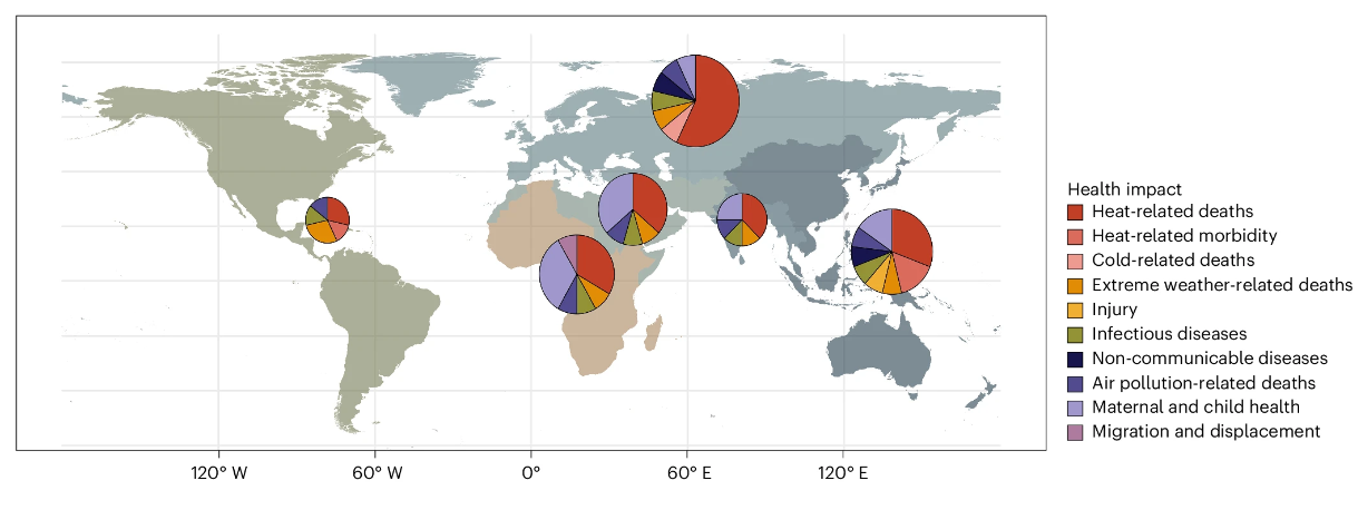
Work on the health impacts of climate change has focused on long-term trends in health outcomes and their relationship with temperature and precipitation.| Geography
Climate and health modelling is necessary for improving understanding of the current and future distribution and timing of climate-related health risks. However, underinvestment in this area has limited the understanding required to inform policies that enable multisectoral interventions to safeguard health. We synthesised insights from a survey of 65 global climate and health modelling experts […] The post Priority climate and health modelling needs appeared first on Geography.| Geography
Work on the health impacts of climate change has focused on long-term trends in health outcomes and their relationship with temperature and precipitation.| Geography
Freezing rain events, which have caused billions of dollars in damage in recent decades, are still one of the least understood forms of precipitation. These events affect both urban and rural regions, including cities and forests. However, the often short-lived and sporadic occurrence of these events poses significant challenges to accurate reporting, complicating analysis attempting […] The post Temporal and spatial analysis of freezing rain regimes over Eastern North America appeared firs...| Geography
In a recent study published in Remote Sensing, researchers from the University of Florida’s Department of Geography have taken a big step forward in showing how artificial intelligence (AI) can help us better understand the changing landscape of agriculture. The work, led by Ph.D. student Mashoukur Rahaman, with co-authors Dr. Jane Southworth, Dr. Yixin Wen, […] The post Assessing model trade-offs in agricultural remote sensing appeared first on Geography.| Geography
Precipitation whiplash, the rapid shift from drought to flooding, or vice versa, exacerbates the impact of both extremes compared to if they were to occur separately. The recognition of these types of events is relatively recent, and event precursors, driving meteorology and impacts are poorly understood. In response to this, this review summarizes the current […] The post Precipitation whiplash events: What causes them and their impacts over the US appeared first on Geography.| Geography
Commuting backbones represent the most essential connections within a commuting network—those significant flows that link major residential and employment areas and structurally support regional mobility systems. Identifying these backbones is critical for understanding large-scale travel demand, informing infrastructure investment, and supporting transportation planning at regional and national levels. Despite their importance, no publicly available datasets […] The post Constructing the...| Geography
