05/03/2024 2024's Atlantic Hurricane Season Could Set Records for Ferocity and Frequency A More Urgent Push to Prepare Your Business Update: Newly Released NOAA Forecast With the 2024 Atlantic hurricane season beginning, NOAA has revised its forecast, predicting an above-normal season. NOAA now expects an 85% chance of above-normal activity, anticipating 17 to 25 named storms, 8 to 13 hurricanes, and 4 to 7 major hurricanes. This increase is driven by near-record warm ocean temperatures and ...| Meteomatics Articles - EN
07/13/2023 A Busier Hurricane Season Expected Despite El Niño A More Urgent Push to Prepare Your Business Despite El Niño, long-range forecasters at Colorado State University expect a busier Atlantic hurricane season, and now’s the time to prepare your business. Fox Weather invites Paul Walsh, CEO of Meteomatics North America, to share insights into the updated forecast. Colorado State University, renowned for its long-range predictions, has recently updated its forecast for the hurricane...| Meteomatics Articles - EN
By Andy May The Oceanic Niño Index or ONI is NOAA’s primarily indicator for monitoring the sea surface temperature (SST) anomaly in the critical Niño 3.4 region. It is a 3-month running mean of ERS…| Andy May Petrophysicist
I’m sometimes asked how ocean circulation can naturally cause global warming, with many assuming solar variability or under sea volcanoes to be the indirect immediate cause. My New Theory of Climate Resilience will focus instead on ocean upwelling dynamics, particularly in the Eastern Equatorial Pacific (EEP), and their modulation by lunar cycles. And I’m thinking […] The post How Climate Works: Upwellings in the Eastern Pacific and Natural Ocean Warming appeared first on Jennifer Maroh...| Jennifer Marohasy
2024 was warmest year on Earth since direct observations began. In Berkeley Earth's analysis 2024 was 1.62 °C above our 1850-1900 average, making it the second year above 1.5 °C.| Berkeley Earth
LOOK. Relief operations of Sagip Kanayunan, Damayang Simbahan laban sa Disaster,Youth Action on El Nino Network and Bayanihan Alay sa Sambayanan in Bulacan for farmers affected by El Nino. More tha…| updates from the peasant movement of the Philippines
Farmers and consumers demand anew the junking of the Rice Liberalization Law, import Liberalization, and seeks compensation to affected rural-based sectors whose livelihood were damaged by El Niño …| updates from the peasant movement of the Philippines
RELIEF DRIVE FOR FARMERS, FISHERS, AND PEASANT WOMEN AFFECTED BY EL NIÑO Oplan Sagip Kanayunan and Tulong Anakpawis rural emergency relief operations are coordinating with the Youth Action on El Ni…| updates from the peasant movement of the Philippines
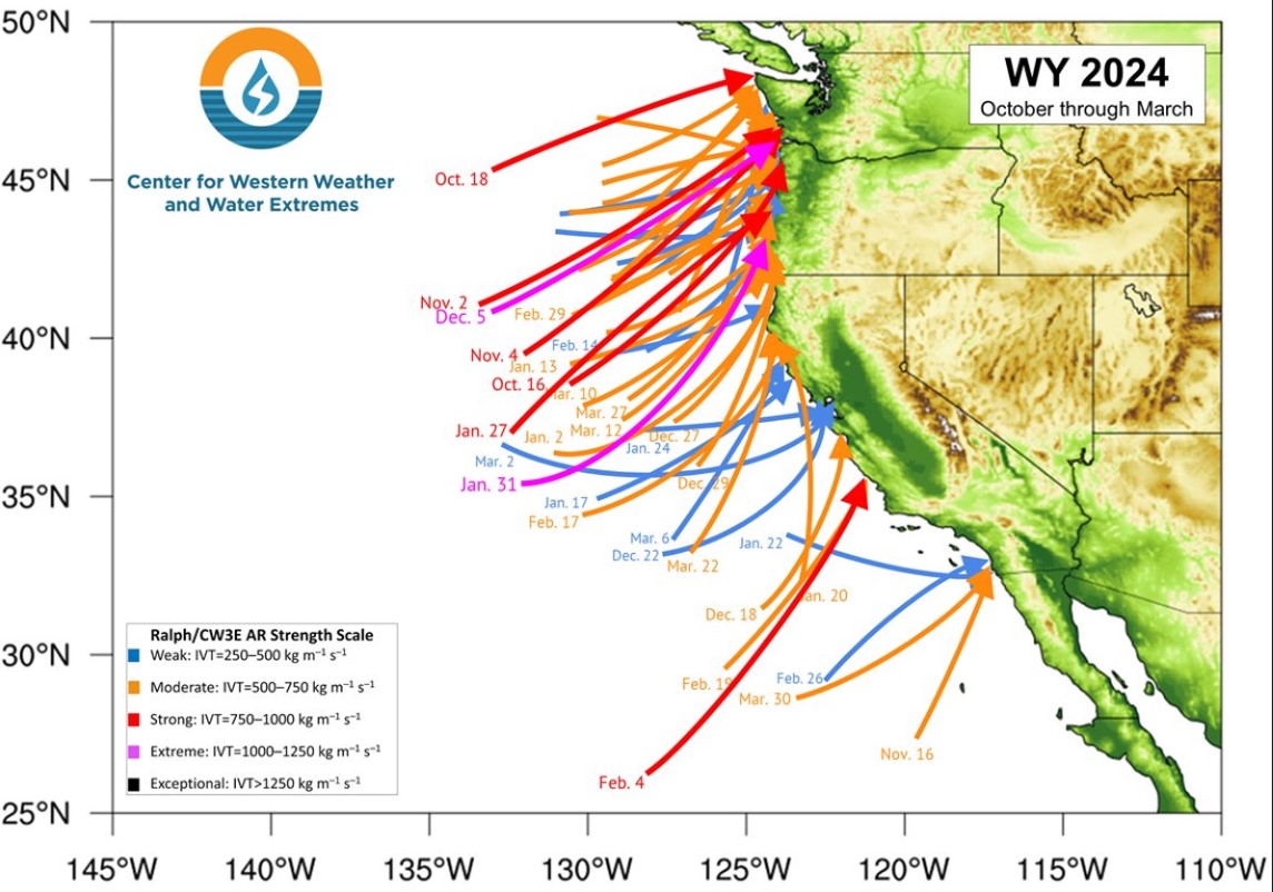
Tomer's Take: I typically stop regular ski/snow blog posts after April 1 each season. Going forward, I'll post less frequently with other topics. In this post I cover Western Snowpack, a look back at my Winter forecast, May 2024 forecast, La Nina Watch, and Summer Monsoon forecast.| Meteorologist Chris Tomer
Tomer's Take: It's a powder day in UT/WY/CO! The next storm system hits the Sierra this afternoon then rolls towards the Four Corners with snow for UT/WY/CO/NM through 4/1. A pattern shift after 4/2 delivers 1-2 additional Canadian storm storm systems. The first week of April looks active.| Meteorologist Chris Tomer
Tomer’s Take: Big totals are likely through 4/6 with 3-4 different storm systems, and I think we’re looking at an active April with above normal snowfall across parts of Colorado’s Western Slope, Utah’s Wasatch, and Wyoming’s Tetons. Timing Wasatch: L/M Tonight, L PM 3/29, H 3/30 – AM 4/1, H PM 4/4-4/6. Tetons: M 3/30, […] The post Snow forecast through 4/6 appeared first on Meteorologist Chris Tomer.| Meteorologist Chris Tomer
Tomer’s Take: Two storm systems are lined-up through 4/2 then a pattern shift occurs with a third storm system dropping south from Canada with heavy snow accumulation. Timing Two Storm Systems Through 4/2 Then Shift North. Third Storm System Trending Stronger 4/3-4/6. Sierra: H Tonight – AM 3/28, H PM 3/29-3/31. Tetons: H 3/28, L […] The post Snowy Period Ahead through 4/5 appeared first on Meteorologist Chris Tomer.| Meteorologist Chris Tomer
Tomer's Take: Light to moderate snow accumulation hits UT/WY/CO through early 3/27. Heavier accumulation arrives 3/28-3/31 with two additional storm systems. A pattern change occurs 4/3-4/5 with energy dropping south out of Canada/BC/PNW.| Meteorologist Chris Tomer
NOAA has issued an official La Niña watch, expecting significant weather changes later in the year, including the Winter of 2024/2025| Severe Weather Europe
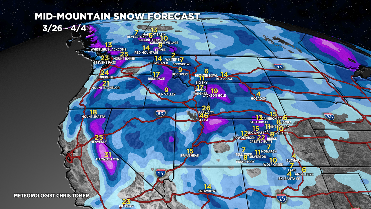
Tomer’s Take: It’s a powder Monday in UT/WY/CO/NM! This storm system is pivoting through Southern Colorado and New Mexico next 12-24 hours then away. There are three additional storm systems lined-up through 4/3. Timing *Updated 4pm 3/25/2024. Storm System pivots out of CO/NM. Three Storm Systems Remaining through 4/3. Sierra: H PM 3/27-3/30. Tetons: L […] The post Three Storm Systems Through 4/3 appeared first on Meteorologist Chris Tomer.| Meteorologist Chris Tomer
Tomer's Take: A strong storm system spins up in SE CO/NM tonight through 3/25 with heavy snow accumulation and 30-50mph wind gusts. The heavy snow continues into 3/26 in NM. There are three additional storm systems lined-up for the West through 4/2.| Meteorologist Chris Tomer
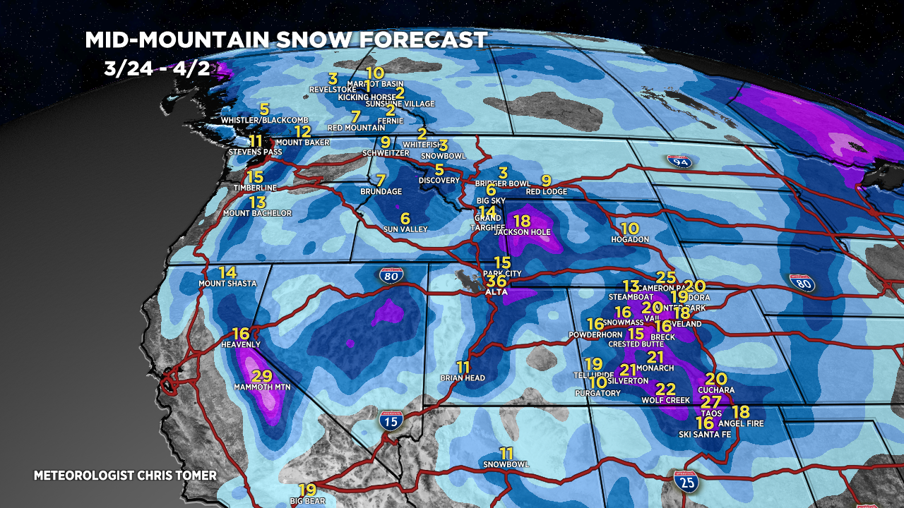
Tomer’s Take: I’m forecasting four different storm systems for the West through late 3/31 with feet of grand total accumulation. Timeline *Updated 4pm 3/22/2024. Snow moving into the Sierra tonight through early 3/24. Four Storm Systems Through 3/31. Sierra: H Accum PM 3/22- AM 3/24, H 3/27-3/30. Tetons: H Accum 3/23-3/24, L 3/26-3/27, H 3/28-3/31. […] The post This Weekend & Beyond appeared first on Meteorologist Chris Tomer.| Meteorologist Chris Tomer
Tomer's Take: Now I'm seeing four different storm systems through 3/30. This means feet of grand total accumulation for PNW/MT/ID/CA/WY/UT/CO.| Meteorologist Chris Tomer
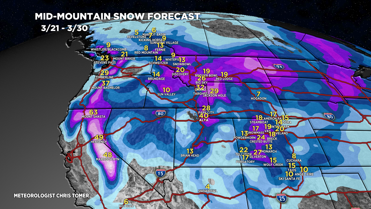
Tomer’s Take: Big totals are likely 3/22-3/28 with three different storm systems lined-up for PNW/BC/MT/ID/CA/UT/WY/CO. Timing Pattern Shift After 3/21, Three Storm Systems. Sierra: Heavy Accum PM 3/22 – AM 3/24. Tetons: L/M Accum 3/21, H 3/23-3/28. Wasatch: Light Accum PM 3/21, H 3/23-3/28. Colorado: Light Accum PM 3/21-3/22, H 3/23-3/28. Banff Area: Heavy Accum […] The post Big totals with three storm systems lined-up through 3/28 appeared first on Meteorologist Chris Tomer.| Meteorologist Chris Tomer