600 geostationäre Satelliten sind im Betrieb und decken einen sehr großen Teil der Erdoberfläche ab. Jede einzelne Empfangsstation kann Unmengen an Daten innerhalb eines Umkreises von ca. 1000 km abgreifen. Ein Wahnsinnsdatenvolumen – das oftmals unzureichend gesichert ist. Diese Daten sind nicht nur für die Geheimdienste, sondern auch für Kriminelle interessant, daher kann die unverschlüsselte […]| Dr. Datenschutz
How to Use and Make the Most of Your GPS Data By Ryan Miller, Account Executive at PlayerData; former Baylor University football player | Guest Post for SimpliFaster Introduction Have you ever watched a game and seen two players swap jerseys only to notice they were wearing what appears to be a sports bra under […] The post How to Use and Make the Most of Your GPS Data appeared first on SimpliFaster.| SimpliFaster
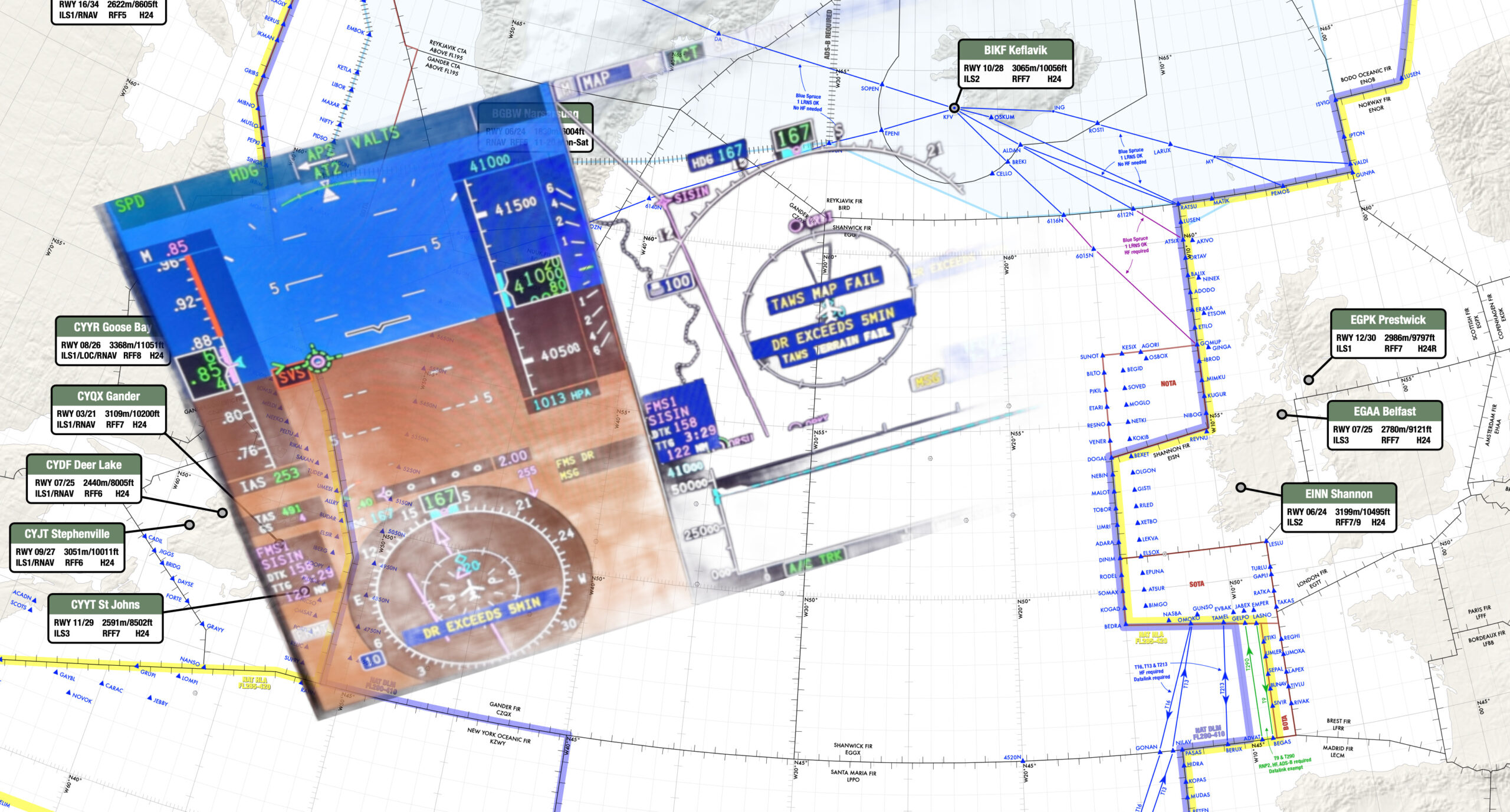
An OPSGROUP member on a recent westbound NAT flight from the Middle East received the following message via CPDLC: The crew contacted Shanwick via HF, who requested their RNP capability and operational status. The controller explained that due to their point of departure (OMAA/Abu Dhabi) they wa| International Ops 2025 - OPSGROUP
With the GPSmyCity app, you’ll never be lost again… And for the next 2 weeks, you can get a free upgrade on my Dante walk in Florence… The post A Gift for You from Curious Rambler and GPSmyCity appeared first on Margo Lestz - The Curious Rambler .| Margo Lestz – The Curious Rambler
From Wednesday 1st October, every GP practice in England must keep their online booking open all day during working hours (8am-6:30pm) - no more closing these systems and forcing everyone onto jammed phone lines. This delivers on our manifesto promise …| Department of Health and Social Care Media Centre
« Tu marches un moment dans la foule. Les gens arrivent à avancer en criant : « Non au plan de licenciement. » Ça t’impressionne. Tu cries avec eux : « Non à la réalité. » « GPS » de Lucie Rico… Plus|
The 746 Test Squadron’s DI testing, with its end-to-end traceability, offers a rapid, cost-effective and low-risk alternative to traditional testing methods.| Inside GNSS - Global Navigation Satellite Systems Engineering, Policy, and De...
El Ayto. de Madrid instala un sistema de balizas electrónicas bluetooth para que aplicaciones como Google Maps o Waze tengan cobertura.| Villaviciosadigital
Learn why it’s important to add location information to photos. Improve storytelling, preserve memories, and make your photo library easier to search in Mylio Photos.| Mylio Photos Blog
A look at the main concerns noted during the comment period.America’s Global Positioning System (GPS) is simultaneously amazing, indispensable and vul| Inside GNSS - Global Navigation Satellite Systems Engineering, Policy, and De...
Authors: Peter Byers1, Antonella Schwarz2, Lauren Stern3, Gabriel J. Sanders4, Corey A. Peacock1 1Department of Health and Human Performance, Nova Southeastern University, Davie FL USA 2Department of Health Promotion and Clinical Practice, Barry University, Miami Shores FL| The Sport Journal
Learn key strategies for training football players—balancing strength, speed, and recovery to maximize on-field performance and reduce injuries.| SimpliFaster
U-blox, a global provider of leading positioning and wireless communication technologies and services, has expanded its partnership with Nordian to deliver its PointPerfect Flex (PPP-RTK) centimeter-level correction services across Argentina and Paraguay, building on existing coverage in Brazil as p| Inside GNSS - Global Navigation Satellite Systems Engineering, Policy, and De...
Focal Point Positioning, a next-generation global navigation satellite system (GNSS) solution company, and STMicroelectronics have announced that they are to| Inside GNSS - Global Navigation Satellite Systems Engineering, Policy, and De...
The Australian Defence Force (ADF) has formally stood up a Joint Positioning, Navigation and Timing (PNT) Directorate, a 17-member unit that has reached initia| Inside GNSS - Global Navigation Satellite Systems Engineering, Policy, and De...
NEURONAV is an advanced AI-augmented positioning system developed for maritime navigation, designed to enhance the accuracy of Global Navigation Satellite Syste| Inside GNSS - Global Navigation Satellite Systems Engineering, Policy, and De...
Signal structure and ephemeris and timing error correction. Finding alternative positioning, navigation and timing (PNT) technologies to GNSS is more pressing t| Inside GNSS - Global Navigation Satellite Systems Engineering, Policy, and De...
NATO’s easternmost member states are grappling with a sharp rise in radio and satellite interference, with Baltic governments accusing Russia of positioning equipment for electronic warfare close to their borders.| gCaptain
Are you afraid of leaving your puppy at home alone? Discover with us how to monitor your four-legged friend when you are not at home. We have the solution for you.| PetLink
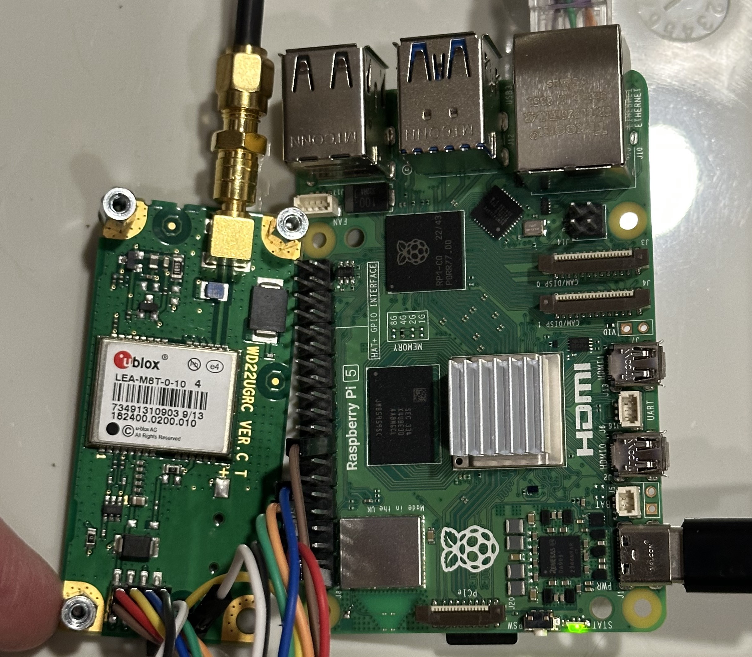
I am receiving reliable gps data from my Adafruit gps sensor. I would like to to show the gpsd.utc data across the screen so that it appears like a regular clock. I have the following code which sh...| Raspberry Pi Stack Exchange
Au cas où l’exemple de la liste de course de la semaine dernière n’ait pas fait mouche, l’analogie du GPS peut être utile pour convaincre product owner ou parties prenantes (du marketing au PDG) du fonctionnement adéquat de l’estimation ou de sa valeur. C’est parti ! Siri, je veux aller chez le coiffeur Lorsque vous … Continue reading Estimons l’estimation part 2 : le backlog comme le trajet de votre GPS The post Estimons l’estimation part 2 : le backlog comme le trajet de...| Constantin Guay
I’m not good with directions. I never could find where we were on that big paper Rand McNally map, so when the first GPS came out, I considered it to be a marriage saver. Until| When the House is Quiet
For those of you of sufficient age, you should have heard that title in your head with the stentorian voice of this fine announcer. But in all seriousness, the U.S. Space Force and U.S. Space Command have their work cut out for them, developing doctrine and strategy and educating the public on the contributions of space to daily life in the modern world. A.P. Penaflor joins host Jacqueline Whitt in the studio to discuss space, a topic that once held nations spellbound but has become so routin...| A Better Peace: The War Room Podcast
BAE Systems unveiled a diverse line of M-Code Global Positioning System (GPS) receiver solutions at the Joint Navigation Conference in Cincinnati this week, ro| Inside GNSS - Global Navigation Satellite Systems Engineering, Policy, and De...
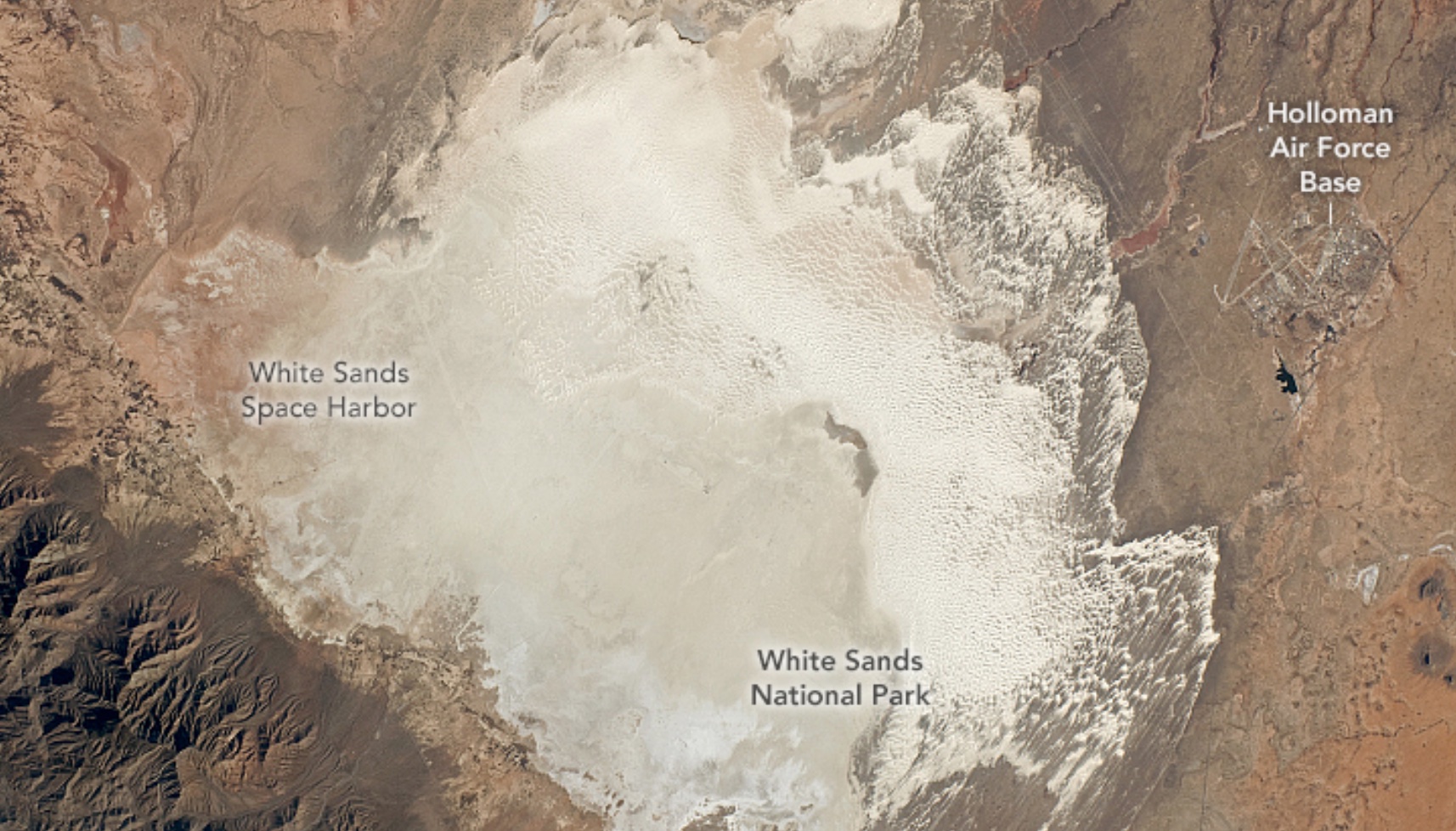
A simulation-based analysis of the 746th Test Squadron’s Locata non-GPS based positioning system for navigation testing at White Sands Missile Range (WSMR).| Inside GNSS - Global Navigation Satellite Systems Engineering, Policy, and De...
Gypsy stopped talking to me. This makes me very sad since it took three years to find her. Gypsy is my GPS system, also known as Apple CarPlay, in my 2020 Toyota RAV 4 LE. (I’ve come to the realization that LE stands for Low End. I have to actually insert and turn a key,... The post My Gypsy appeared first on Renner Writes.| Renner Writes
I don’t need to go there. ~Swami Khecaranatha When I use my car’s GPS to set my route to a particular destination, sometimes I miss a turn or even intentionally take a little detour, distracted by one thing or another. The nice computer lady who gives me directions never fusses at me. I see the […]| Galen Pearl
You may have heard that a small minority of people have not been invited to screening appointments because of an error in how GP offices have registered them. This issue affects screening invitations for bowel cancer, breast cancer, cervical cancer, and …| Department of Health and Social Care Media Centre
Zephr.xyz, a provider of augmented position, navigation, and timing (AugPNT) technologies, has been awarded a $1.74 million Small Business Innovation Research| Inside GNSS - Global Navigation Satellite Systems Engineering, Policy, and De...
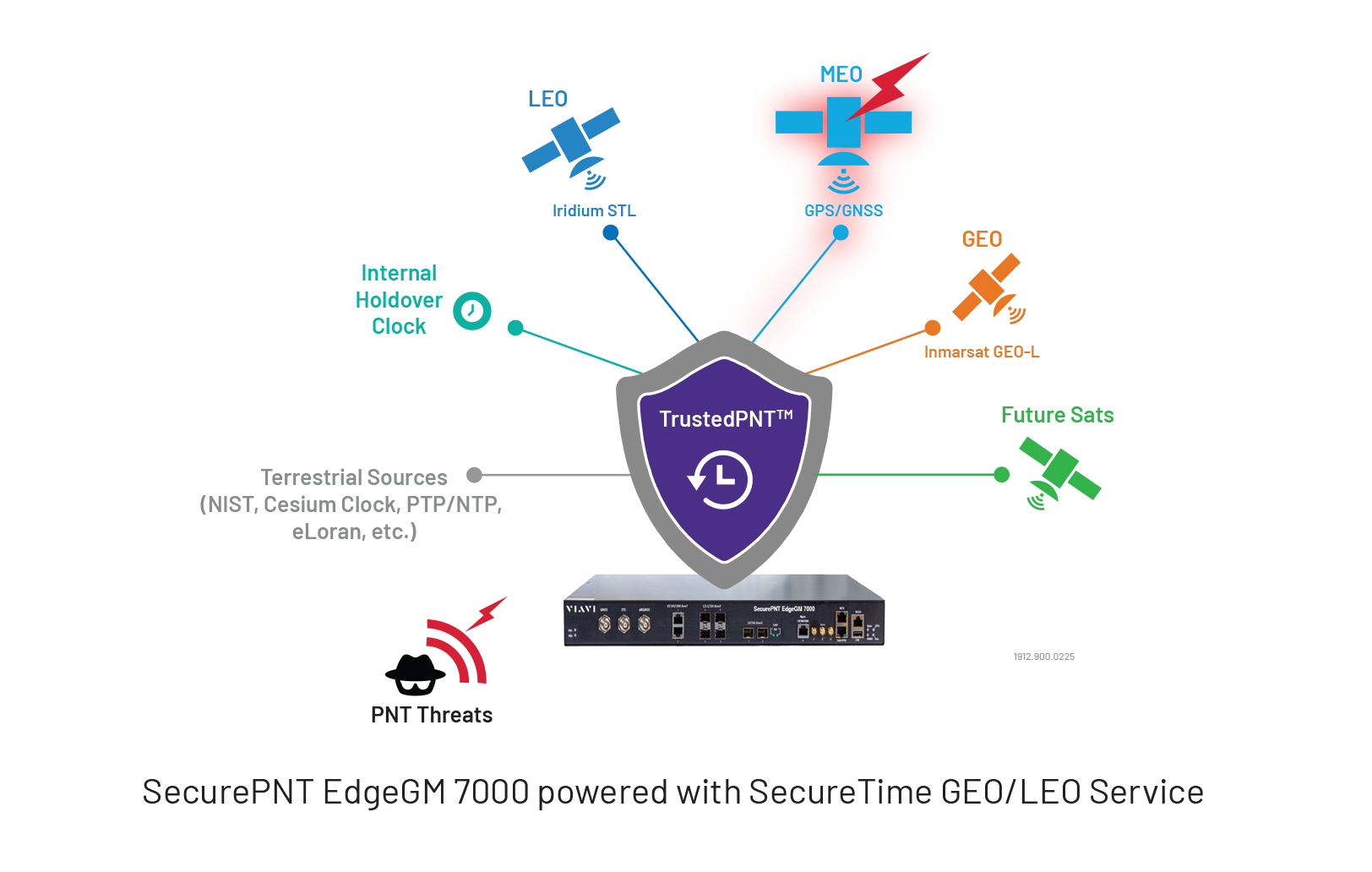
VIAVI Solutions Inc. has launched EdgeGM 7000, a highly resilient Edge Grandmaster Clock building on the SecurePNT portfolio. EdgeGM 7000 offers up to 25G Pr| Inside GNSS - Global Navigation Satellite Systems Engineering, Policy, and De...
Topcon Positioning Systems and Pix4D have announced a strategic agreement that combines their expertise in geopositioning and photogrammetry solutions. The c| Inside GNSS - Global Navigation Satellite Systems Engineering, Policy, and De...
Introduction Almost four years ago, I wrote the original post to this series – Microsecond accurate NTP with a Raspberry Pi and PPS GPS. Some things have changed since then, some haven’t. PPS is still an excellent way to get a microsecond accurate Raspberry Pi. Some of the commands and configurations have changed. So let’s […]| Austin's Nerdy Things
A research and development project headed by Geospatial Ventures Limited (GVL) has unveiled new artificial intelligence (AI)-based positioning, navigation and| Inside GNSS - Global Navigation Satellite Systems Engineering, Policy, and De...
Le Digital Markets Act (DMA), un nouveau règlement européen qui entre en vigueur ce mois de mars, change le fonctionnement des différents services développés par Google.| Le HuffPost
A Global Navigation Satellite System (GNSS) aims to provide Earth-based position and navigation. Spaceborne GNSS receivers have become universal sensors for spa| Inside GNSS - Global Navigation Satellite Systems Engineering, Policy, and De...
A look at lunar in-situ PNT GNSS-like frequencies and how we can open the “radio window” into the universe. JEAN-LUC ISSLER, JEAN PLA, ROMAIN DESP| Inside GNSS - Global Navigation Satellite Systems Engineering, Policy, and De...
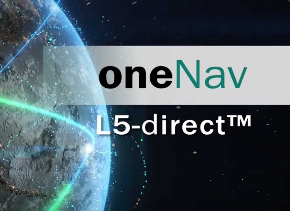
GPS technology developer oneNav has announced the successful results of a test of its technology's resilience to widespread GPS interference. The test| Inside GNSS - Global Navigation Satellite Systems Engineering, Policy, and De...
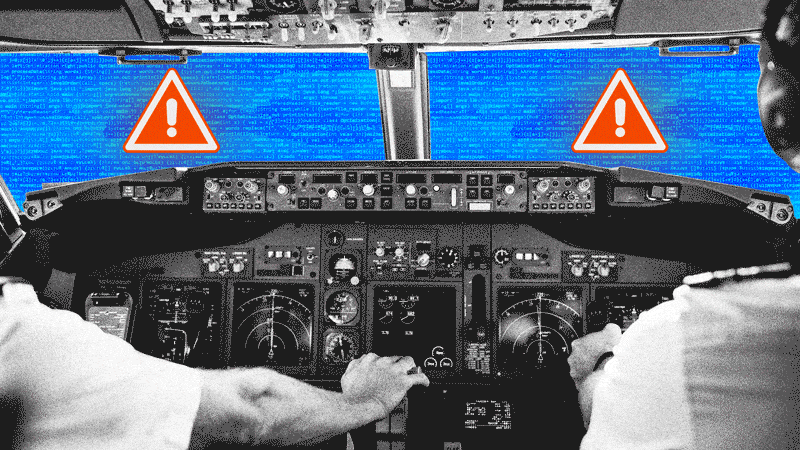
An increasing issue for the NAT Oceanic FIR's is how to handle aircraft with an in-flight degradation of GPS. This normally follows a GPS Spoofing encounter somewhere prior to Oceanic Entry, leading to a degraded RNP capability. If you run into GPS issues before entering the Ocean, you will likel| International Ops 2025 - OPSGROUP
I use Replicant on my main Samsung S3 mobile phone. Replicant is a fully free Android distribution. One consequence of the “fully free” means that some functionality is not working properly, because the hardware requires non-free software. I am in Continue reading GPS on Replicant 6→| Simon Josefsson's blog
Since November 2013 I have been using Replicant on my Samsung S3 as an alternative OS. The experience has been good for everyday use. The limits (due to non-free software components) compared to a “normal” S3 (running vendor ROM or Continue reading Replicant 4.2 on Samsung S3→| Simon Josefsson's blog
Got my hands on a Sprint Airave (full model number SPDSC26UCS) in the hopes of being able to hack it, but the FPGA ended up being an Altera HardCopy II chip, which is basically an FPGA that is hard-coded to remove the FP (Field Programmable) functionality. So, not wanting to waste a $40 investment, I decided to take pictures of the insides in the hopes that it will help someone figure out some hacks for it. If you need more-detailed pictures, let me know and I'll be happy to take them for you...| Cyrozap's Tech Projects
Recently, I bought a Nikon D5100. It is the best camera I have ever owned. EVER. You have no idea how happy I am with my purchase of it (and I should be happy with it—at $840, it's nowhere near cheap). One of the awesome features it has is GPS input. It can take TTL serial GPS data and use it to geotag pictures. This is awesome, but it comes with a catch: Nikon's GPS is $250! It's also absurdly bulky. Wanting geotagging that I can easily disable (I don't want home pictures, etc. to be tagge...| Cyrozap's Tech Projects
The Map Happenings series on the hugely impactful events that forever changed our world. This week: a deep dive in to how we all figure out where we are. It’s a fascinating story. Read on!| Map Happenings
En este artículo vamos a ver como saber la ubicación de un celular gratis, gracias al rastreo vía satélite. Este tutorial es compatible para cualquier persona del mundo ya que localizar un número por satélite solo requiere de 3 satélites, y esto es completamente posible desde todos los países. Este proceso de localización es el menos habitual ya que es utilizado principalmente por herramientas de profesionales (localizadores GPS de vehículos o sistemas de radar para barcos y aviones...| Espiar Movil Nu9
Do you or a loved one live to hike? Searching for the perfect present? Here are some of the best gifts ideas that are sure to please an avid hiker! (Click on items for more details) Fire Starter GPS Hiking Books Maps Hydration Pack Water Purification Hiking Food Hiking ShoesRead More| Your Hike Guide
At the moment I'm living in a block of flats and my mailbox is in a central lobby area. I'm often receiving small surprise packets from China and never know when the postman has been, usually between 8 and 12, sometimes even twice a day! I also don't have any road facing windows that I can look out...| Zak's Electronics Blog
Quick demonstration of Time Difference of Arrival (TDoA) technique to correlate a common transmitted signal on multiple receivers to find the transmitter's location.| Ham Radio . Magnum Experimentum