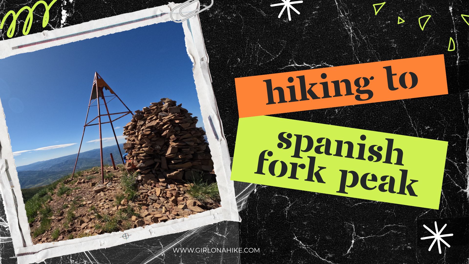
Hiking to Hiking to Spanish Fork Peak, Spanish Fork, Utah - Girl on a Hike
The Award-Winning blog, "Girl on a Hike, follows hiking enthusiast Alicia, and her hiking companion, Charlie, a Golden Lab, on their outdoor adventures.| Girl on a Hike
The Award-Winning blog, "Girl on a Hike, follows hiking enthusiast Alicia, and her hiking companion, Charlie, a Golden Lab, on their outdoor adventures.| Girl on a Hike
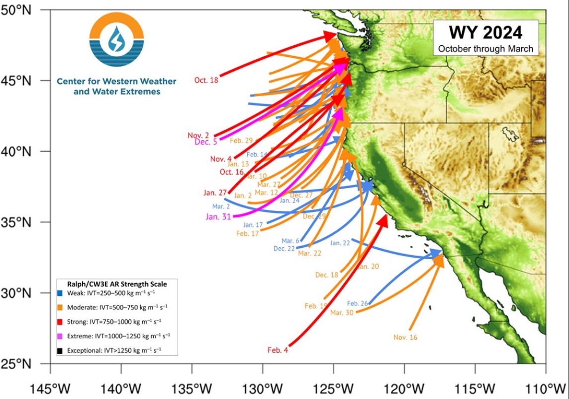
Tomer's Take: I typically stop regular ski/snow blog posts after April 1 each season. Going forward, I'll post less frequently with other topics. In this post I cover Western Snowpack, a look back at my Winter forecast, May 2024 forecast, La Nina Watch, and Summer Monsoon forecast.| Meteorologist Chris Tomer

Tomer's Take: It's a powder day in UT/WY/CO! The next storm system hits the Sierra this afternoon then rolls towards the Four Corners with snow for UT/WY/CO/NM through 4/1. A pattern shift after 4/2 delivers 1-2 additional Canadian storm storm systems. The first week of April looks active.| Meteorologist Chris Tomer
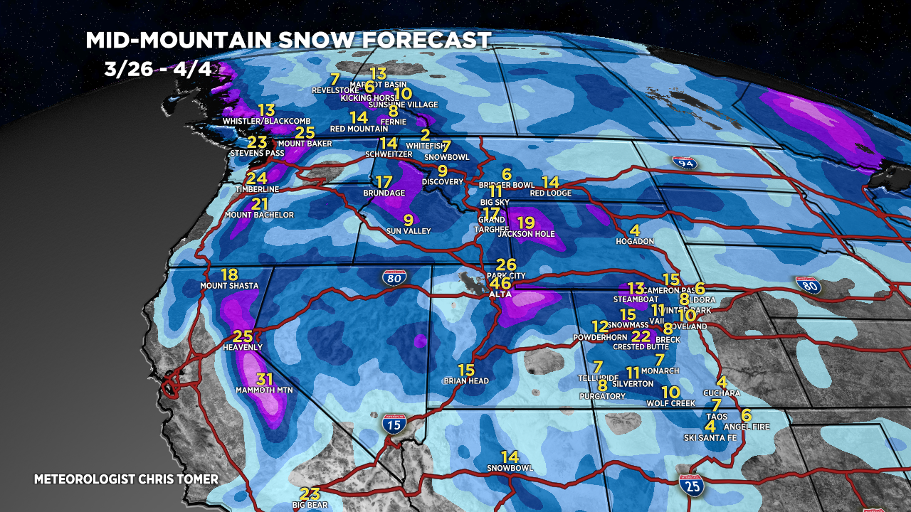
Tomer’s Take: Big totals are likely through 4/6 with 3-4 different storm systems, and I think we’re looking at an active April with above normal snowfall across parts of Colorado’s Western Slope, Utah’s Wasatch, and Wyoming’s Tetons. Timing Wasatch: L/M Tonight, L PM 3/29, H 3/30 – AM 4/1, H PM 4/4-4/6. Tetons: M 3/30, […] The post Snow forecast through 4/6 appeared first on Meteorologist Chris Tomer.| Meteorologist Chris Tomer
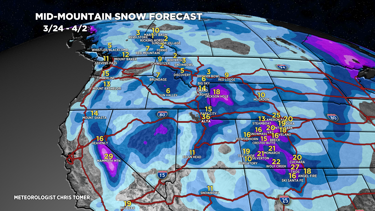
Tomer’s Take: Two storm systems are lined-up through 4/2 then a pattern shift occurs with a third storm system dropping south from Canada with heavy snow accumulation. Timing Two Storm Systems Through 4/2 Then Shift North. Third Storm System Trending Stronger 4/3-4/6. Sierra: H Tonight – AM 3/28, H PM 3/29-3/31. Tetons: H 3/28, L […] The post Snowy Period Ahead through 4/5 appeared first on Meteorologist Chris Tomer.| Meteorologist Chris Tomer
Tomer's Take: Light to moderate snow accumulation hits UT/WY/CO through early 3/27. Heavier accumulation arrives 3/28-3/31 with two additional storm systems. A pattern change occurs 4/3-4/5 with energy dropping south out of Canada/BC/PNW.| Meteorologist Chris Tomer
Tomer’s Take: It’s a powder Monday in UT/WY/CO/NM! This storm system is pivoting through Southern Colorado and New Mexico next 12-24 hours then away. There are three additional storm systems lined-up through 4/3. Timing *Updated 4pm 3/25/2024. Storm System pivots out of CO/NM. Three Storm Systems Remaining through 4/3. Sierra: H PM 3/27-3/30. Tetons: L […] The post Three Storm Systems Through 4/3 appeared first on Meteorologist Chris Tomer.| Meteorologist Chris Tomer
Tomer's Take: A strong storm system spins up in SE CO/NM tonight through 3/25 with heavy snow accumulation and 30-50mph wind gusts. The heavy snow continues into 3/26 in NM. There are three additional storm systems lined-up for the West through 4/2.| Meteorologist Chris Tomer
Tomer’s Take: I’m forecasting four different storm systems for the West through late 3/31 with feet of grand total accumulation. Timeline *Updated 4pm 3/22/2024. Snow moving into the Sierra tonight through early 3/24. Four Storm Systems Through 3/31. Sierra: H Accum PM 3/22- AM 3/24, H 3/27-3/30. Tetons: H Accum 3/23-3/24, L 3/26-3/27, H 3/28-3/31. […] The post This Weekend & Beyond appeared first on Meteorologist Chris Tomer.| Meteorologist Chris Tomer
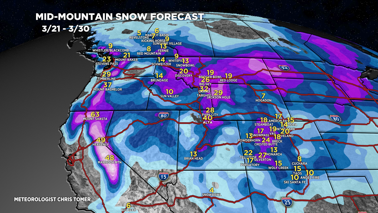
Tomer's Take: Now I'm seeing four different storm systems through 3/30. This means feet of grand total accumulation for PNW/MT/ID/CA/WY/UT/CO.| Meteorologist Chris Tomer
Tomer’s Take: Big totals are likely 3/22-3/28 with three different storm systems lined-up for PNW/BC/MT/ID/CA/UT/WY/CO. Timing Pattern Shift After 3/21, Three Storm Systems. Sierra: Heavy Accum PM 3/22 – AM 3/24. Tetons: L/M Accum 3/21, H 3/23-3/28. Wasatch: Light Accum PM 3/21, H 3/23-3/28. Colorado: Light Accum PM 3/21-3/22, H 3/23-3/28. Banff Area: Heavy Accum […] The post Big totals with three storm systems lined-up through 3/28 appeared first on Meteorologist Chris Tomer.| Meteorologist Chris Tomer
