
Understanding How Carbon Storage Can Help Meet Climate Goals - Geography Realm
The storage of carbon is a critical part of rebalancing the carbon cycle to ensure that climate change is less severe than many predict.| Geography Realm
The storage of carbon is a critical part of rebalancing the carbon cycle to ensure that climate change is less severe than many predict.| Geography Realm

Researchers analyzed forest loss rates across the entire Amazon between 2001 and 2014.| Geography Realm

Researchers applied machine learning to satellite-derived datasets to to analyze tillage practices and crop yields in the US Corn Belt.| Geography Realm

To cope with ever-changing agricultural needs and conditions, the USDA uses data from Landsat to monitor crops in the contiguous United States.| Geography Realm

The global carbon budget is the amount of carbon gained and lost in the natural and manmade workings of the world. The global carbon budget is part of the greater carbon cycle and the ways in which the Earth’s reservoirs of carbon are added to and subtracted from. The global carbon budget can be directly ... Read more| Geography Realm
A review of research found that marine species were shifting their habitats toward Earth’s poles on an average of six kilometers (3.7 miles) per year.| Geography Realm
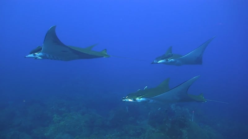
A variety of applications using GIS, remote sensing and GPS tracking of individuals per collars have advanced in the last years and are increasingly used for mapping and tracking elephants.| Geography Realm

Because of global warming, the Dawn redwood might unexpectedly make it back to the wilderness of its ancient habitats in North America.| Geography Realm

MAAP has used remote sensing to discover a correlation between deforestation and forest fires in Tampbopata, Peru.| Geography Realm

Researchers have used satellite data to analyze images for areas that should be protected as green spaces which in turn help protect Atlanta’s water supply.| Geography Realm

"Drought, Flood, Fire: How Climate Change Contributes to Catastrophes" is written by a scientist who understands how to meaningfully inform his non-scientist readers.| Geography Realm

Researchers have found that trees growing faster due to warming conditions are also dying faster.| Geography Realm

A team of scientists from the UK's Botanic Gardens Conservation International has compiled the first comprehensive list of all the world's tree species.| Geography Realm

In late November and early December, flooding plagued South India and particularly Chennai. AJ Rohn takes a look at the confluence of climate change and urban India.| Geography Realm

Due to colder weather and more strong atmospheric rivers, the 2023 Sierra Nevada snowpack levels in California are significantly above average.| Geography Realm
Biogeography| Geography Realm

Keystone species are plants or animals whose presence in an ecosystem plays a crucial role in its health.| Geography Realm

Smoke from the June 2023 Canadian wildfires is affecting the Midwest and northern regions of the United States.| Geography Realm

There are three main ways in which carbon can be removed from the atmosphere: physical processes, chemical processes and biological processes.| Geography Realm

Australasia is a unique geographical and ecological zone compromised of Australia, New Zealand, New Guinea, and other small islands nearby.| Geography Realm
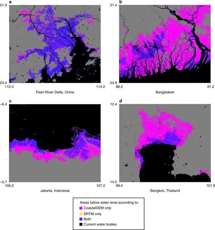
New estimates from Climate Central estimate that 340 million to 480 million people would be affected by flooding in coastal areas due to sea level rise.| Geography Realm
Geography Realm covers research and case studies about the applications of geography, GIS, geospatial technologies, and cartography.| Geography Realm

Landsat imagery and NDVI are used to monitor vegetation change, from invasive grass spread in rangelands to early stress detection in coastal marshes.| Geography Realm
GIS Data| Geography Realm
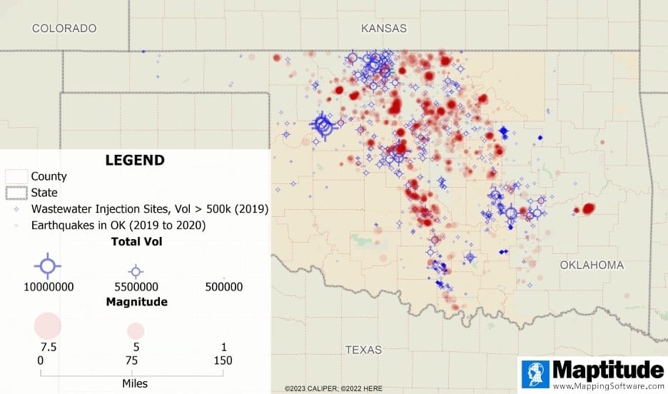
Mapping software can help us observe trends in earthquakes, identify areas of high earthquake prevalence, and explore relationships between earthquakes and other phenomena.| Geography Realm

In partnership with scientists and researchers, farmers are coming up with different ways to keep soil from degrading and releasing more CO2 into the air.| Geography Realm

Research suggest that the world’s deserts may be storing some of the climate-changing carbon dioxide emitted by human activities.| Geography Realm
A global dataset of 700 mud volcanoes was recently published by geologists from Sapienza University. The post GIS Data: Shallow Sea Mud Volcanoes appeared first on Geography Realm.| Geography Realm
FAO’s global dataset maps access to towns and cities of all sizes within realistic travel times, highlighting patterns of urban interconnectedness. The post Explore the City-Regions Dataset from FAO appeared first on Geography Realm.| Geography Realm
Study maps 540 million years of sea level change, showing major short-term shifts during ice ages driven by Earth's orbital cycles. The post Mapping Short-term Sea Level Changes Over 540 Million Years appeared first on Geography Realm.| Geography Realm
Groundwater stored over many years is a significant contributor to streamflow in Western United States mountains according to a published study. The post Water Can Take Years to Seep out of Mountains appeared first on Geography Realm.| Geography Realm
Bubbles created by the movement of waves can influence how much carbon dioxide is absorbed by the ocean. The post Study Models How the Behavior of Waves Affects Blue Carbon Storage appeared first on Geography Realm.| Geography Realm
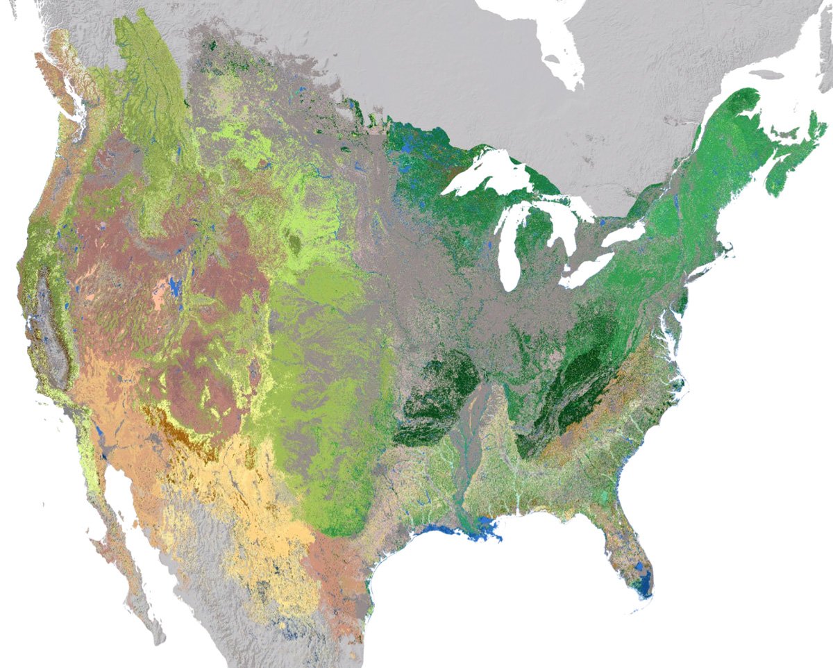
NatureServe has developed an updated 30-meter hexagon map of regional ecosystems in the contiguous United States and adjacent areas.| Geography Realm
Lake Chapala was formed at the intersection of three grabens. The post Lake Chapala: a Tectonic Lake at Mexico’s Triple-graben Intersection appeared first on Geography Realm.| Geography Realm

Read about how the Amazon once flowed east to west and how the strength of Hurricane Isaac once change the course of the Mississippi river.| Geography Realm

A project called the Earth Archive plans to use Light Detection And Ranging (LiDAR) to map the entire surface of the Earth.| Geography Realm
Above the Arctic Circle, Point Barrow is the northernmost point in the United States. The post Northernmost Point in the United States appeared first on Geography Realm.| Geography Realm
Geography Basics| Geography Realm

Learn more about lines you see on a map running east-west and north-south called latitude and longitude.| Geography Realm

LiDAR systems are used to collect high resolution topographic and bathymetric data.| Geography Realm

Researchers from the Crowther Lab recently published a study in Science which reviewed existing research on soil communities and how climate change will accelerate the loss of carbon stored in the world's soil.| Geography Realm

Using remote sensing, a team of researchers is studying the fragile arctic environments of Northwest Siberia and how resource extraction and a warming climate affect vegetation, permafrost, and energy budgets.| Geography Realm

The Old Weather project is a crowdsourcing data gathering endeavor to understand and map historical weather variability.| Geography Realm

How does pollution from plastic, trash, and oil spills move around Earth's oceans?| Geography Realm

Two-million-year-old DNA from Greenland's permafrost reveals a rich ancient ecosystem, including mastodons, showing past climate impacts and adaptation.| Geography Realm
This is the disclaimer page for Geography Realm.| Geography Realm
This is the copyright policy page for Geography Realm.| Geography Realm

GeographyFun features maps, crosswords, and word searches for educators, students, and geography enthusiasts who love exploring the world through words.| Geography Realm

The easiest way to tell if a country is landlocked is to take a look at a map of the country and the surrounding geography.| Geography Realm

Drought conditions in much of the United States are forecasted to continue for spring 2021.| Geography Realm

Deforestation is a problem we are likely all familiar with, even in passing. We drive or walk by small or large tracts of land with evidence that something is missing- from tree stumps to conspicuously empty land, deforestation is something that is happening in rainforests, mountains, and urban and rural areas all around the world ... Read more| Geography Realm

Researchers have discovered that structurally diverse forests are better at carbon sequestration that monocultures.| Geography Realm

The researchers found that the Arctic region has transitioned from a carbon sink to a source of carbon emissions.| Geography Realm

Geographic information and weather data recorded by ship crews are a valuable source of historical information that could be utilized to understand how our climate has changed.| Geography Realm

Nasa’s Goddard Institute for Space Studies (GISS) has announced that September 2016 was the warmest September ever recorded around the globe.| Geography Realm

Paleoclimate has had a major effect in shaping not only physical geography but also biodiversity in different parts of the Earth.| Geography Realm

This is the web site of Geography Realm (formerly Geo Lounge).The editor, Caitlin Dempsey, can be reached via e-mail at editor@geographyrealm.com or via physical mail at 1200 Franklin Mall # 524, Santa Clara CA 95052 USA. Google Analytics This website collects data from visitors in order to improve site performance and to better understand how visitors are using ... Read more| Geography Realm

Learn about which countries in South America are landlocked.| Geography Realm

Researchers in Global Change Biology explore how Arctic melt, merging the Pacific and Atlantic oceans, impacts animal migration.| Geography Realm

Researchers have been able to create a better picture of tectonic plates by using both earthquake vibrations and seismic waves.| Geography Realm

The worksheet below is aimed towards helping elementary school students uses graphs to learn about the different continents and the population density of each continent (printable version of this lesson about continents and population). The chart below shows the size and population of each continent and should be used to answer the following question. First, ... Read more| Geography Realm

Recently published research looked at the question of, "Instead of looking at how drought affects the forest, how might this go the other way around?"| Geography Realm

NASA's Orbiting Carbon Observatory-2 is a major source of information about the life cycle of carbon dioxide on Earth.| Geography Realm

Ecologists have found that climate change, as it changes precipitation levels and temperatures, is causing trees to grow in different locations than they have traditionally taken root.| Geography Realm

Remote sensing technologies and satellite images were used to map where the California drought is affecting trees the most.| Geography Realm

Changes that are normally brought about by climatic variations have caused major environmental concerns worldwide. These changes without doubt bring about a crisis of huge proportions which affects the regulators of environment economically, socially and even politically too. When the weather pattern shifts for instance, this normally leads to a very big threat in the ... Read more| Geography Realm

Researchers have used LiDAR to understand the impacts of Native American population decline on forest fires in the United States.| Geography Realm

Boreal forests are changing along with our climate.| Geography Realm

Datasets of paleoenvironmental variability contained in a variety of pluvial lakes is a treasure-trove of past climate conditions.| Geography Realm

Steeper slopes cause water to flow more rapidly, strengthening its ability to erode the surrounding land and carve out channels that form the tributaries.| Geography Realm

Cartographers have been creatively crafting heads and bodies out of mountain ranges, coastlines, and other physical features. These anthropomorphic maps were intended mostly as propaganda pieces to show off the might of one country or stereotype foreign lands.| Geography Realm

Continents are defined as the largest continuous landmasses on earth.| Geography Realm

The trend of coloring in prefabricated pictures is over 400 years old, and one of the first coloring books ever created is being republished. This early coloring book was of maps and mythical images, entitled Albion’s Glorious Ile.| Geography Realm

These zoomorphic maps were designed as propaganda tools, with each one depicting the world in a way that reflected the message the cartographer intended to convey.| Geography Realm

Find out the answers to geography trivia questions and more in this article about the geography of U.S. National Parks.| Geography Realm

Measuring the economic benefits of wildlife and outdoor areas supports conservation with tools like the NPS Visitor Spending Effects.| Geography Realm

Scientists and conservationists are working to find refuge areas in order to further land management plans and climate change predictions.| Geography Realm

Researchers have mapped out where to plant trees to mitigate climate change.| Geography Realm

Drought, more intense fires, and invasive species are changing the forest landscapes in Western United States.| Geography Realm

Climate change is creating a vegetation climate mismatch in the conifer forests of California's Sierra Nevada.| Geography Realm

The impact of climate change is reducing the amount of habitat where the trees of North America can thrive.| Geography Realm

Along the geography of the East Coast of the United States, large swathes of forest are declining at increasing rates.| Geography Realm

Climate change is causing certain key species in the Sierra Nevada mountains to change where they are growing according to a study published by the journal California Fish and Game.| Geography Realm

Boreal forests in North America are defying predictions of northward expansion in response to climate change.| Geography Realm

The San Francisco Bay was once connected to a large salt marsh that contained many different and rare species of plants and animals. Conservationists are now restoring the salt marsh.| Geography Realm

A joint NASA-USGS initiative has created the first worldwide map of the causes of change in mangrove habitats between 2000 and 2016.| Geography Realm

A collaboration initiative, called coastTrain, helps to provide data so that scientists can better address challenges coastal regions face.| Geography Realm

Scientists in Australia have discovered that mangrove ecosystems in Queensland are dying at rates that have never been seen before.| Geography Realm

The Alviso Slough in the San Franciso Bay is a restored salt marsh that lies in the path of the Pacific Flyway.| Geography Realm

The Earth's lithosphere is divided into tectonic plates, which are in constant motion. Learn where to find GIS data on tectonic plates.| Geography Realm

Researchers looked at the link between cool air pooling and cold-adapted forest composition.| Geography Realm

This GIS tutorial teaches you how to assign geographic coordinates to a scanned map in QGIS using a process known as georeferencing.| Geography Realm

Researchers are studying how wolves shape forests by limiting beaver foraging, keeping them close to water to avoid predation.| Geography Realm
