The tropical disturbance we've been following is finally within the National Hurricane Center's seven-day window, so they're now drawing a big lemon in the Caribbean where the system has a chance of developing. The long line from the disturbance's current location in the central Tropical Atlantic to the eastern Caribbean is an indication that development is not expected before the system gets to the vicinity of the islands. On the current schedule, the disturbance is forecast to move into...| Hurricane Intel
The National Hurricane Center has a clean slate for the next seven days. After that time, the various computer forecasts continue to show a decent chance that the tropical disturbance over the far eastern Atlantic will track into the Caribbean next week and eventually develop. The models show a weather pattern over the central and western Caribbean that would be conducive to the disturbance organizing, and some show strengthening, if the system gets that far. On the current schedule, the...| Hurricane Intel
A disorganized tropical disturbance is plodding across the stretch of ocean from Africa to the Caribbean. Atmospheric conditions do not look conducive for it to develop much before it reaches the islands - most likely the Windward Islands - next Sunday or Monday. Once it reaches the western Caribbean later next week, however, some computer forecasts predict the pattern will allow the system to organize and strengthen. The possibilities range from no development at all to a strong hurricane...| Hurricane Intel
The tropical disturbance that moved off Africa over the weekend is slowly tracking west across the tropical Atlantic. It's quite far south and east for a system this time of year, although occasionally these systems occur. The consensus of the various computer forecasts is that the disturbance will track toward the Caribbean, arriving near the islands next Sunday or Monday. There is no indication in any of the models that the system would be strong at that time, but of course it will bear...| Hurricane Intel
The relentless Nor'easter is in its final stages, though today's midday or afternoon high tides are forecast to be the highest of the storm in some locations. By the high tide cycle overnight, levels will be somewhat lower, and the winds should have subsided substantially. Some rain will linger along the coast into tomorrow, especially in southeastern New England. The system is stretched south to north along the East Coast with two centers of low pressure - one off the North Carolina coast...| Hurricane Intel
If it were winter, we would be talking about a blizzard with feet of snow. The weather pattern is the same, but the temperature is not...| Hurricane Intel
The storm will strengthen as it tracks offshore of the Carolinas later today. Winds will increase along the coast, especially around the...| Hurricane Intel
A non-tropical area of low pressure is developing near the Central Florida east coast along the cold front that's pushing south. The low...| Hurricane Intel
Tropical Storm Jerry has run into some hostile upper winds, which has slowed its intensification. The fast-moving system is avoiding the...| Hurricane Intel
The well-formed tropical disturbance tagged Invest 95L is on the cusp of becoming a depression or Tropical Storm Jerry. The National...| Hurricane Intel
The National Hurricane Center has designated the tropical disturbance in the eastern Atlantic as Invest 95L. That just means we now have...| Hurricane Intel
The broad, disorganized disturbance in the far eastern Atlantic doesn't seem to know what month it is. It’s trying to act like a system...| Hurricane Intel
The National Hurricane Center is highlighting two areas for potential development. The area near Florida and the Bahamas is related to...| Hurricane Intel
LIVE HURRICANE Q&A at 4 PM ET on YouTube, Facebook, TikTok, X, Instagram, and LinkedIn. Today my special guest will be Ferran Alet, a...| Hurricane Intel
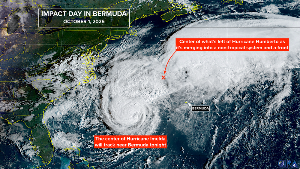
Hurricane Imelda is on track to pass very near Bermuda late today. It’s been battling Hurricane Humberto for supremacy. The hurricanes...| Hurricane Intel
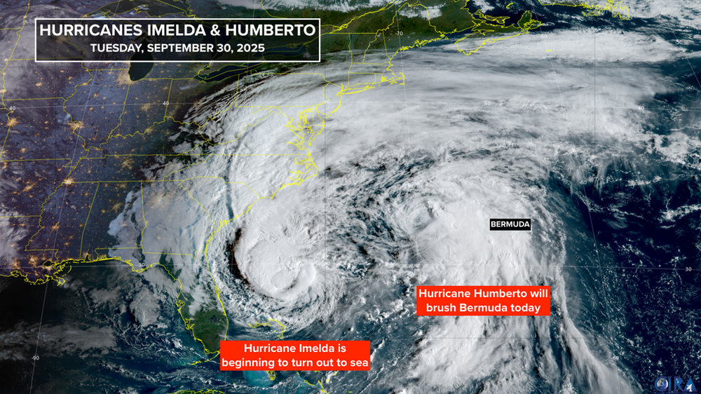
Imelda has attained hurricane strength and has begun its turn out to sea away from Florida. Category 2 Hurricane Humberto is a little...| Hurricane Intel
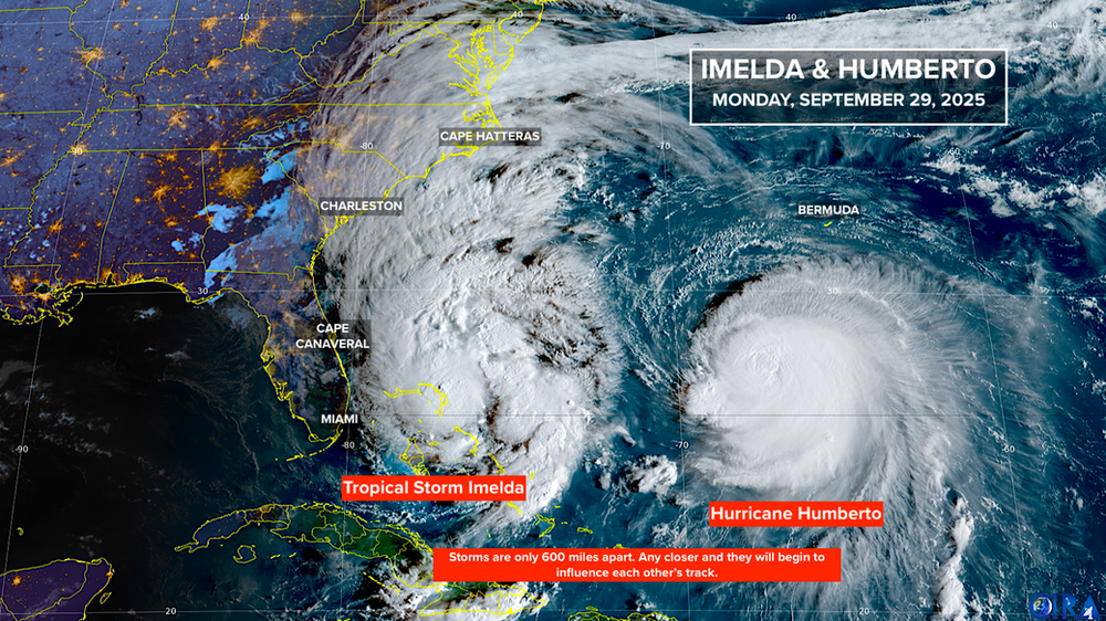
The center of Tropical Storm Imelda is just passing the northwestern Bahamas. It will proceed north, well offshore of the Florida coast...| Hurricane Intel
The tropical disturbance we've been following in the central tropical Atlantic has been upgraded to Tropical Depression Seven. The system is still fighting with the dust and dry air, but the National Hurricane Center deemed its circulation sufficiently well developed to classify the system a depression. You can see the dusty air impacting the west side of the elongated circulation. The system is expected to eventually push off the hostile conditions and develop into Tropical Storm Gabrielle ...| Hurricane Intel
Good tropical news on this Sunday. The tropical disturbance we've been following in the Atlantic has apparently given up any dreams of developing. It's still a cluster of healthy-looking thunderstorms, but there's no sign of any organization. In addition, between its location and the Caribbean is a large pool of extremely dry air. None of the various computer forecasts predict the system will survive the trek through that arid barrier. When the system arrives at the eastern Caribbean islands...| Hurricane Intel
A hostile pall is descending over the tropics, which should limit any significant development for the next week or two or so. Dust and dry air, an unsupportive upper-wind regime, and higher than normal air pressure over the tropical belt should limit development between Africa and the Caribbean. The National Hurricane Center is painting a low-probability potential development area for a disturbance forecast to move off the African coast late in the weekend. It’s going to have tough sleddin...| Hurricane Intel
August 25 was a Thursday in 2005. Just two days before, new Tropical Depression Twelve had formed over the Bahamas. From the get-go, it was predicted to track towards South Florida. The forecast turned out to be excellent, although the storm strengthened a little more than expected. Hurricane Katrina made its first landfall near Hollywood, Florida – just north of the Miami-Dade/Broward County line – at about 6:00 PM ET 20 years ago today. The storm was lopsided, tilted by somewhat hosti...| Hurricane Intel
Giant Hurricane Erin is moving away from land and its effect on the ocean along the East Coast is slowly diminishing. Miraculously, the storm will head out to sea having done little more than brush land areas. The storm's top winds are decreasing and it's accelerating away from land. Erin is forecast to become non-tropical tomorrow and turn into a massive North Atlantic storm. Gusty winds will brush Atlantic Canada as Erin goes by, and the system looks likely to bring bad weather to the UK o...| Hurricane Intel
Hurricane Erin is slowly pulling away from North Carolina. Winds are gusty and tides are elevated, but the worst of the storm stayed right offshore. We’ll still have impacts spreading north all the way to New England, however – whatever happens will peak at the time of high tide along the Northeast coast. Until Erin accelerates out to sea tonight, the large diameter storm is putting a tremendous amount of energy into the ocean that will show up at the beaches and waterways along the East...| Hurricane Intel
Even though Hurricane Erin's top winds are not as intense as they once were, the storm has grown in size so its impacts will spread over a wider area. The atmosphere ahead of Erin looks to be reasonably conducive for intensification, so the National Hurricane Center is forecasting the top winds to increase slightly to the top end of the Category 2 range. The central pressure is already dropping, so the intensification process seems to already be underway. Although in a giant storm, the proce...| Hurricane Intel
The tropical disturbance in the far eastern Atlantic has lost most of its moisture, and the going is going to stay rough. The steering flow is going to bend its track to the north where the air is very dry, the pressure is high, and the upper winds are hostile. The system is likely to continue to lose moisture. There are actually two disturbances in a strung-out area of disturbed weather off the African coast. They are forecast to merge today and tomorrow with what's left of their moisture a...| Hurricane Intel
We have a special LIVE streaming Hurricane HQ&A scheduled this afternoon at 4:00 PM ET. NHC Deputy Director and Storm Surge Expert Jamie Rhome will join me to take your questions about the expected impacts from Hurricane Erin and any other questions you have. We'll be live on Facebook, YouTube, TikTok, X, Instagram, and LinkedIn. Hope to see you then. Hurricane Erin is slowly pulling away from the Bahamas and dramatically growing in size. The top winds have weakened to Category 2 – but th...| Hurricane Intel