In May this year we officially launched the Climate Action Navigator (CAN): HeiGIT’s new dashboard offering high-resolution, open data-based insights into key climate action indicators. From assessing CO2 emissions from residential heating to urban active mobility infrastructure, CAN helps identify where targeted action is most urgently needed. In this fifth post of our blogpost series, […]| GIScience Blog
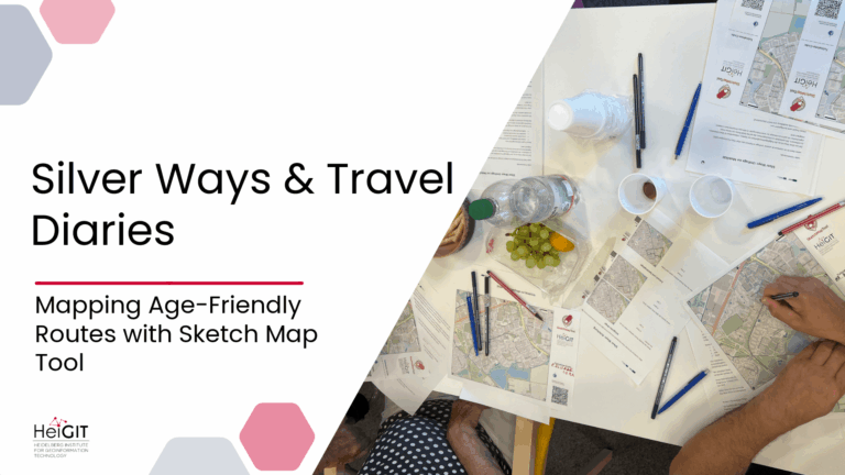
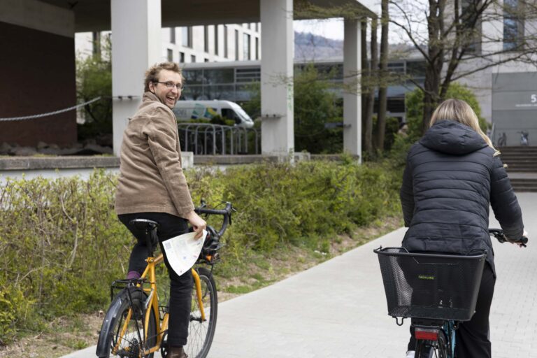
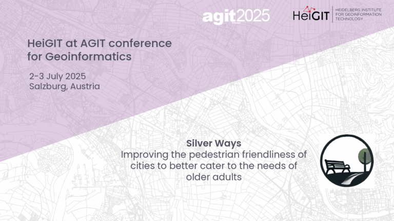
The Silver Ways project aims to make it easier for older adults to get around cities by creating a routing system targeted to their needs. To ground this system in lived experience, the team conducted a series of workshops with elderly groups across Mannheim.| GIScience Blog
HeiGIT will participate in this year's International Land Use Symposium in Dresden, Germany (November 6-7). The conference brings together theoretical, methodological and practitioners to discuss how spatial insights can advance research, planning and policy.| GIScience Blog
Crowdsourced street-level imagery can be used to detect and map humanitarian-relevant features in near real time. We have developed a machine-learning-based analytical pipeline that integrates with the open-source imagery catalogue Panoramax to support a more flexible disaster response and urban monitoring, especially in underserved regions. This blog article was originally posted on Medium [add link] […]| GIScience Blog
The conference brings together experts, developers, and enthusiasts of open data for two days of talks, workshops, and discussions. HeiGIT will contribute with several different sessions covering a range of topics. “Goodbye OSHDB – Welcome ohsomeDB!” – Benjamin Herfort Friday, November 14, 11:00 AM We will introduce ohsomeDB, the new successor of the OpenStreetMap History […]| GIScience Blog
The ENHANCE project explores how 15-minute city principles can be applied beyond dense urban hubs, using mapping, behavioral research, and simulation tools to design more sustainable and inclusive mobility systems. The ENHANCE project, funded by Driving Urban Transitions to a Sustainable Future (DUT) under JPI Urban Europe, addresses the challenges of implementing 15-minute city (15mC) […]| GIScience Blog
Together with the German Federal Agency for Cartography and Geodesy (BKG) we released a new version of the ohsome dashboard, introducing a new indicator for assessing the thematic accuracy of land cover data in OpenStreetMap (OSM). This development is part of a broader project together with BKG on OSM data quality evaluation. New indicator: Thematic […]| GIScience Blog
Anticipatory Action (AA) is becoming an increasingly vital approach in humanitarian and disaster risk management. By leveraging forecasts and risk data, AA enables timely interventions before extreme events occur. Geoinformation technologies play a key role in operationalizing this approach. In Madagascar, where cyclones regularly cause widespread damage, HeiGIT has been working with Croix-Rouge Malagasy (CRM, […]| GIScience Blog
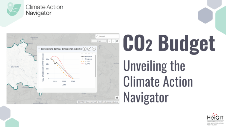
Thanks to the newest addition to the Climate Action Navigator, it is now possible to calculate the remaining CO₂ budget for several German cities (Berlin, Bonn, Hamburg, Heidelberg, and Karlsruhe) to stay within certain global warming limits (e.g. +1,5°C). The CO₂ Budget assessment tool also tracks if the city is on the right track to stay within this budget.| GIScience Blog
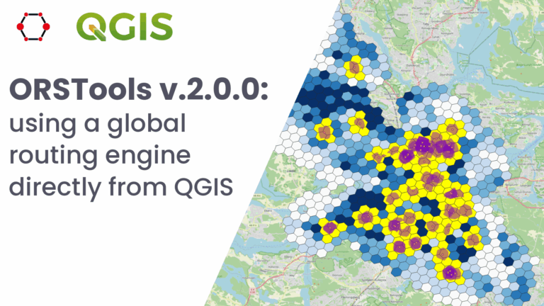
State of the Map World is the annual event for all mappers and OpenStreetMap users. The program consists of talks, workshops, discussion rounds and more. HeiGIT is taking part with three different contributions. ORS-Tools – Beginner-friendly Mobility Analysis with OpenStreetMap and openrouteservice in QGIS – Julian Psotta, Benjamin Herfort Friday, 11:30 (60 minutes (plus Q&A)); Room: […]| GIScience Blog
The 25th International Walk21 Conference on Walking and Livable Communities will take place from 6 - 10 October in Tirana, hosted by the Municipality of Tirana in partnership with GIZ Albania.| GIScience Blog
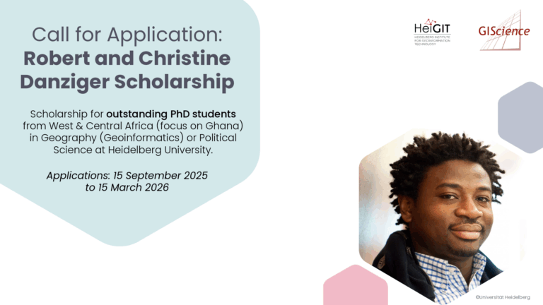
The Robert and Christine Danziger Scholarship supports outstanding doctoral students from West and Central Africa (with particular emphasis on applicants from Ghana), who intend to pursue a doctoral degree in Geography (specializing in Geoinformatics) or Political Science at Heidelberg University. Applicants are expected to be in the process of applying for a doctoral position at Heidelberg University and to be among the best in their research field.| GIScience Blog
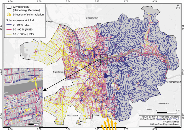
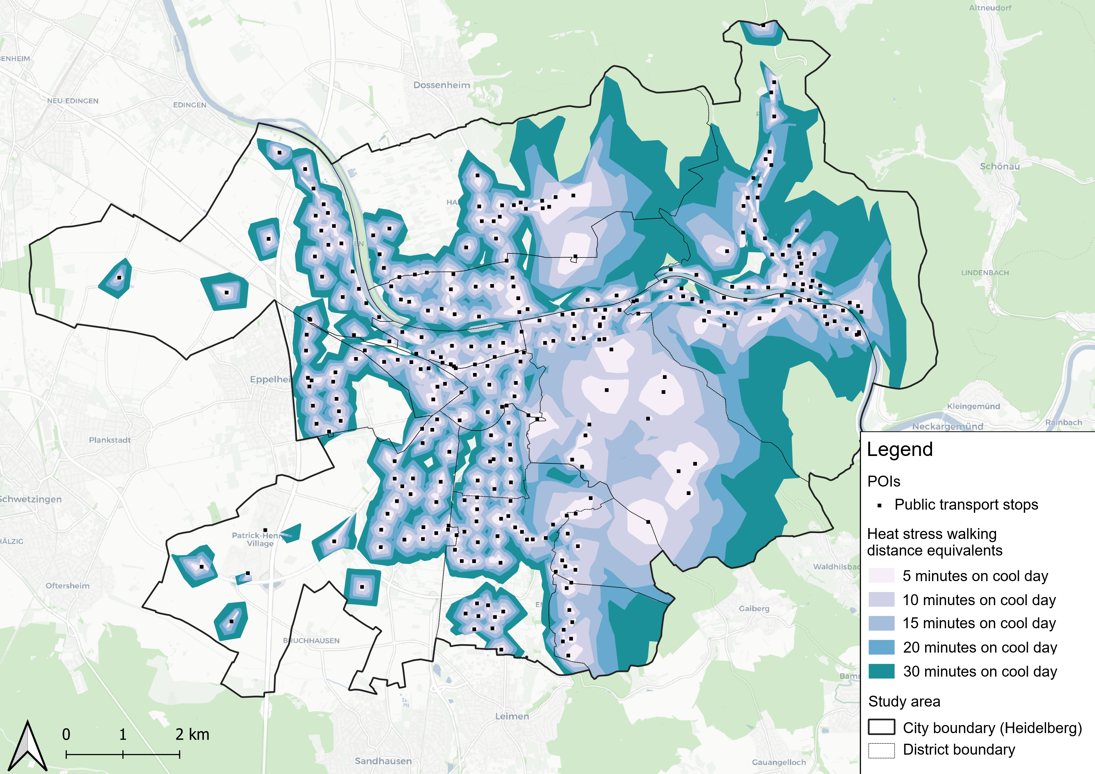
Using Heidelberg as a case study, researchers modeled time-dependent solar exposure for the entire pedestrian network by combining high-resolution DEM/DSM building and vegetation data with OpenStreetMap road data.| GIScience Blog
As part of our ongoing work in Anticipatory Action, a QGIS plugin for risk assessments was developed with the goal of enabling local actors to carry out risk assessments independently and reliably. The tool builds on HeiGIT’s broader efforts to support community resilience by making geoinformation technology more accessible to practitioners in diverse operational contexts.| GIScience Blog
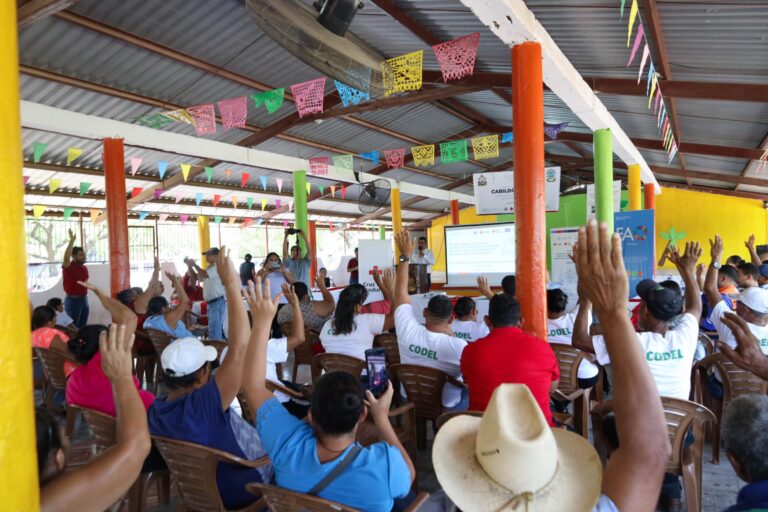
The Sketch Map Tool was used in a joint effort between the Honduran Red Cross and the municipal government to update the municipal response plan and develop an annex focused on anticipatory actions. Participants were asked to map local knowledge about areas affected by flooding and critical infrastructure.| GIScience Blog
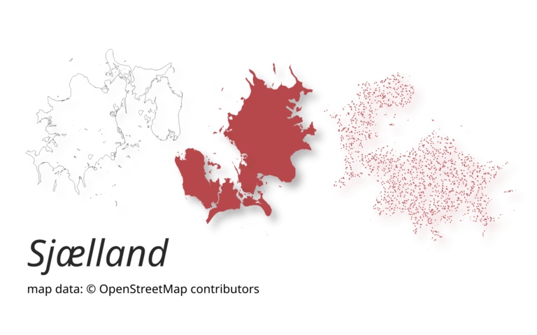
A new version of ohsome-planet (codename “Sjælland”) has been released. It is the newest version of HeiGIT´s command line tool, which transforms OpenStreetMap (history) PBF files into into an analysis-ready data format. We illustrate what ohsome-planet can do by assessing how many OSM edits used Bing Imagery as reference source.| GIScience Blog
Searching for early warning systems during the COVID-19 pandemic, the researchers explored how digital data sources such as geo-social media (e.g. posts on platforms like X, formerly Twitter, that include location data) could improve the disease’s transmission dynamics. This data offers a valuable tool for local event detection.| GIScience Blog
A study published on ScienceDirect evaluates the capability of LLMs to mimic human-like decision-making patterns in parking scenarios. Through experiments, researchers reproduce realistic trade-offs between cost, distance, and availability, while reflecting sociodemographic influences and bounded rationality.| GIScience Blog
This year, the team from HeiGIT is once again participating in the nationwide cycling initiative STADTRADELN. For 21 days, teams across Germany collect bicycle kilometers, raising awareness for climate protection, sustainable mobility, and improved cycling infrastructure. The campaign promotes environmentally friendly transportation – not only in the everyday lives of the participants but also as a signal to policymakers to strengthen cycling infrastructure in cities.| GIScience Blog
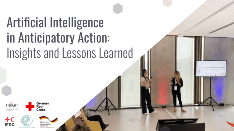
Artificial Intelligence holds great promise for strengthening Anticipatory Action by improving hazard forecasting, vulnerability mapping, and decision support, but must be tailored to real-world humanitarian contexts to really be of benefit. A recent workshop brought together practitioners, researchers, and tech experts to identify gaps, share learnings, and explore how AI can be responsibly and effectively integrated into anticipatory humanitarian efforts.| GIScience Blog
The Peruvanian Andes are among the world’s most impressive cultural landscapes of traditional terrace farming. The lecture explores these pre-Columbian terrace systems as long-term strategies for resource use and adaptation to semi-arid environmental conditions. The focus is on new geoarchaeological findings from the Laramate region (southern Peru), which provides insights into the construction, use and soil-ecological effects of pre-modern terrace systems. The results illustrate how local ...| GIScience Blog
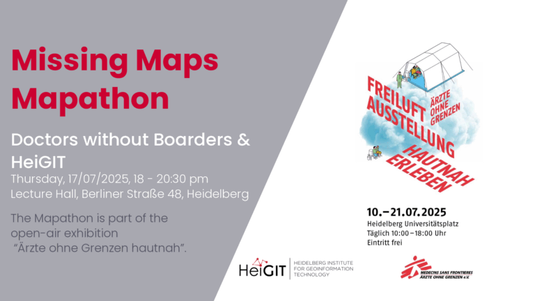
The lack of geographical data makes providing humanitarian aid more difficult. This is particularly the case in situations of disaster, when geographical data and routing data are crucial for coordinating help. In certain regions, however, this data still remains incomplete. During Mapathons, volunteers map these areas and provide the missing data.| GIScience Blog
At the AGIT Conference, researchers, practitioners, and the industry experts talk about their papers on advancements, innovations, and applications in geoinformation and geospatial technologies. GIScience HeiGIT will present a paper about Silver Ways, a project to develop an empirically informed and validated routing system for older people. We will explore the process of developing the routing mechanism and demonstrate how our findings can inform urban policy and planning improvements in col...| GIScience Blog
The diverse geomorphological and geological conditions of Southeast Asia with its wide river deltas, karst landscapes and highlands have a lasting impact on social development and land use in Vietnam. As a result of anthropogenic climate change, the country is subject to strong processes of change and an increased risk of natural disasters. Climate shifts and changing environmental conditions can be reconstructed in paleoarchives over thousands of years. Beyond climate and geology, historical...| GIScience Blog
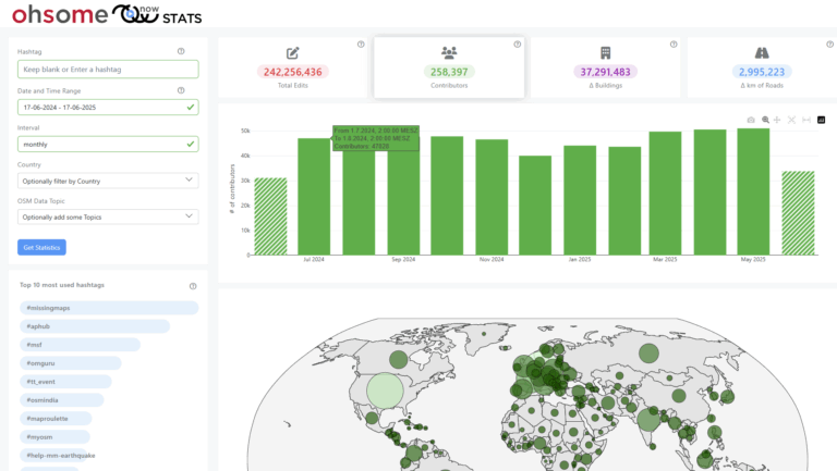
The enhanced ohsomeNow Stats dashboard now provides near real-time access to all OpenStreetMap contributions since 2005, enabling more flexible and detailed analysis of global mapping activities.| GIScience Blog
This study introduces the isocalor approach to assess how solar exposure and heat stress impact pedestrian access to essential services in Heidelberg, using OpenStreetMap data and a customized openrouteservice routing engine.| GIScience Blog
Students of the Institute of Geography at Heidelberg University explored local perceptions of urban heat in Heidelberg’s old town as part of a 2024 seminar on GIS for Disaster Risk Reduction and Humanitarian Aid. The project, supported by Heidelberg Institute for Geoinformation Technology (HeiGIT), tested participatory mapping using the Sketch Map Tool combined with KoboToolbox. | GIScience Blog
The paper addresses the global shortage of detailed road surface data by leveraging street-view imagery from Mapillary and advanced deep learning techniques. Traditional datasets like OpenStreetMap (OSM) often lack comprehensive road surface attributes—with only about 30–40% coverage—hindering applications such as travel time estimation, disaster response routing, urban planning, and environmental assessments. To fill this gap, the paper proposes a novel approach that utilizes heterogen...| GIScience Blog
We’re excited to share the release of the ohsome-planet – a new software library on GitHub, marking a significant step toward the development of ohsome 2.0. This tool is designed to facilitate the transformation of raw OpenStreetMap (OSM) history data into the GeoParquet format, making it more accessible and efficient for spatial data analysis.| GIScience Blog
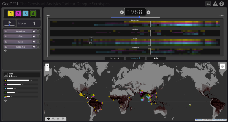
With the increasing availability of global disease datasets, Visual Analytics (VA) has emerged as a valuable tool in spatial epidemiology, particularly for studying serotype interactions in diseases like dengue. Dengue, caused by four serotypes (DENV1-DENV4), poses a significant global health threat exacerbated by urbanization and climate change. Traditional approaches rely on static mapping or animation of serotype incidence, but there remains a gap in utilizing VA tools for dynamic and inte...| GIScience Blog
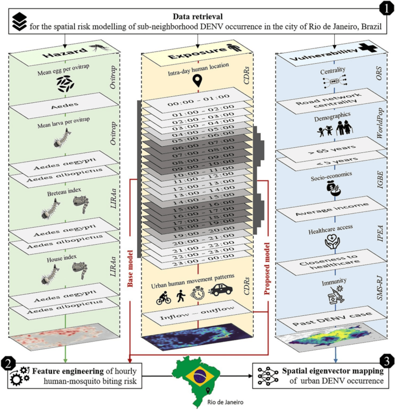
Scientific Reports publishes a paper by Steffen Knoblauch et al. that underscores the critical importance of integrating vector ecology and human behavior into advanced disease modeling frameworks.| GIScience Blog
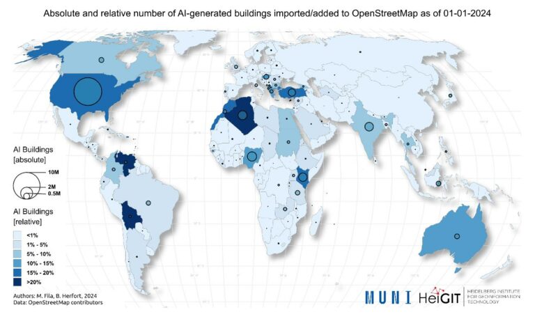
The concept of a “Digital Earth” has long envisioned a future where technological advancements enable the large-scale collection and visualization of spatial and environmental data. Today, open data sources such as OpenStreetMap (OSM) provide crucial spatial information for diverse applications, including urban planning, disaster management, and public health. However, many regions remain insufficiently mapped, particularly in less developed areas. AI-assisted mapping has emerged as a pot...| GIScience Blog
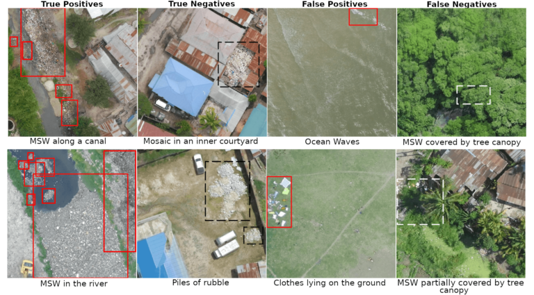
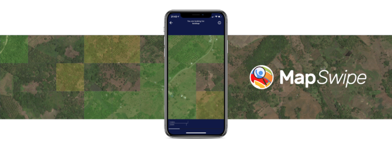
The crowdmapping app MapSwipe now integrates also street-level imagery. This new feature enables even mapping efforts that require the highest level of detail, such as detecting waste on the street.| GIScience Blog
Geospatial technologies offer significant opportunities to address sustainability and resilience challenges by integrating Volunteered Geographic Information (VGI) and remote sensing with environmental science to tackle critical climate-related issues. With the accelerating impacts of rising global temperatures and extreme weather events, communities face increasing demands to manage vital resources, including water, energy, and land. The combined use of VGI and remote sensing holds great pot...| GIScience Blog
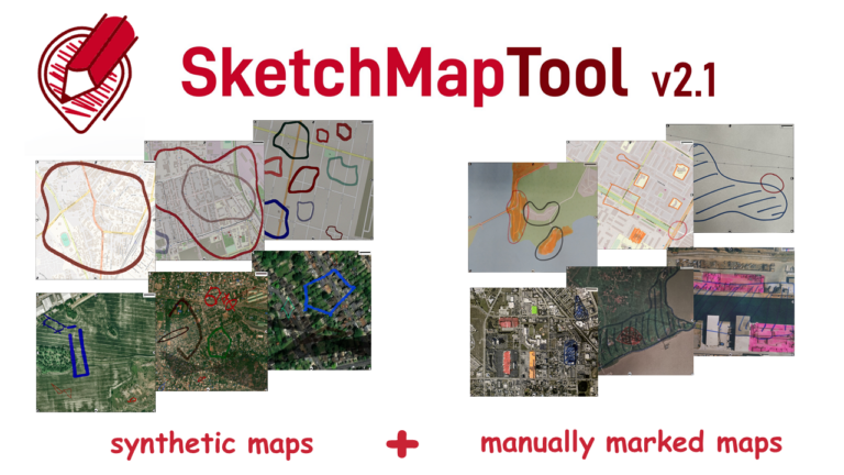
The newly released Sketch Map Tool v2.1 features a higher accuracy in digitizing hand-sketched markings on Sketch Maps, thanks to a larger training dataset and an updated machine learning model for sketch detection. New user metrics show that thousands of Sketch Maps are created every month all over the world.| GIScience Blog
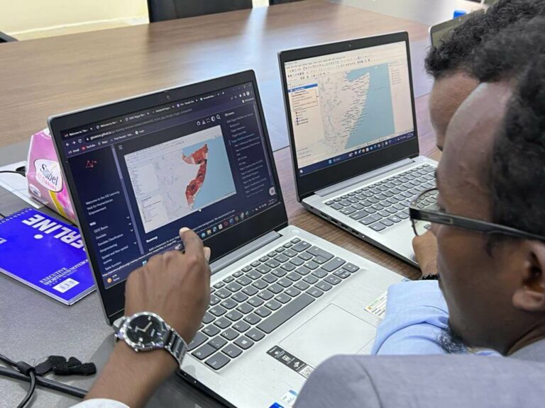
This article was originally published on the website of 510, the data and digital unit of The Netherlands Red Cross: Unleashing the Power of GIS, Together: The IFRC Network GIS Training Platform – 510| GIScience Blog
Data on mobility behavior can yield valuable insights that are beneficial for various applications such as public policy, emergency response, and urban planning. As the availability of freely-accessible mobility data is limited, the attention to X (formerly known as Twitter) as a data source has increased. Users of the platform can tag their online posts with geocoordinates. This data is openly accessible via the API, enabling researchers to deduce human mobility patterns from these informati...| GIScience Blog
August 19th marks World Humanitarian Day (WHD) to recognize the efforts of humanitarian workers and to advocate for the survival, well-being and dignity of people affected by crises, and for the safety and security of aid workers. One of many factors that are essential for effective humanitarian response and the security of people on site is the availability of reliable maps and up-to-date geodata of crisis areas. This is usually ensured through crowdsourcing and there are many tools and proj...| GIScience Blog
You are a highly motivated person who loves spatial data science? You want to use your expertise for the benefit of society and the environment – in particular stimulating Climate Action? You want to improve the availability and quality of geographic information for Climate Action and develop geoinformatics methods used for related open, non-profit applications? Then we actually might have a suitable and interesting job for you!| GIScience Blog
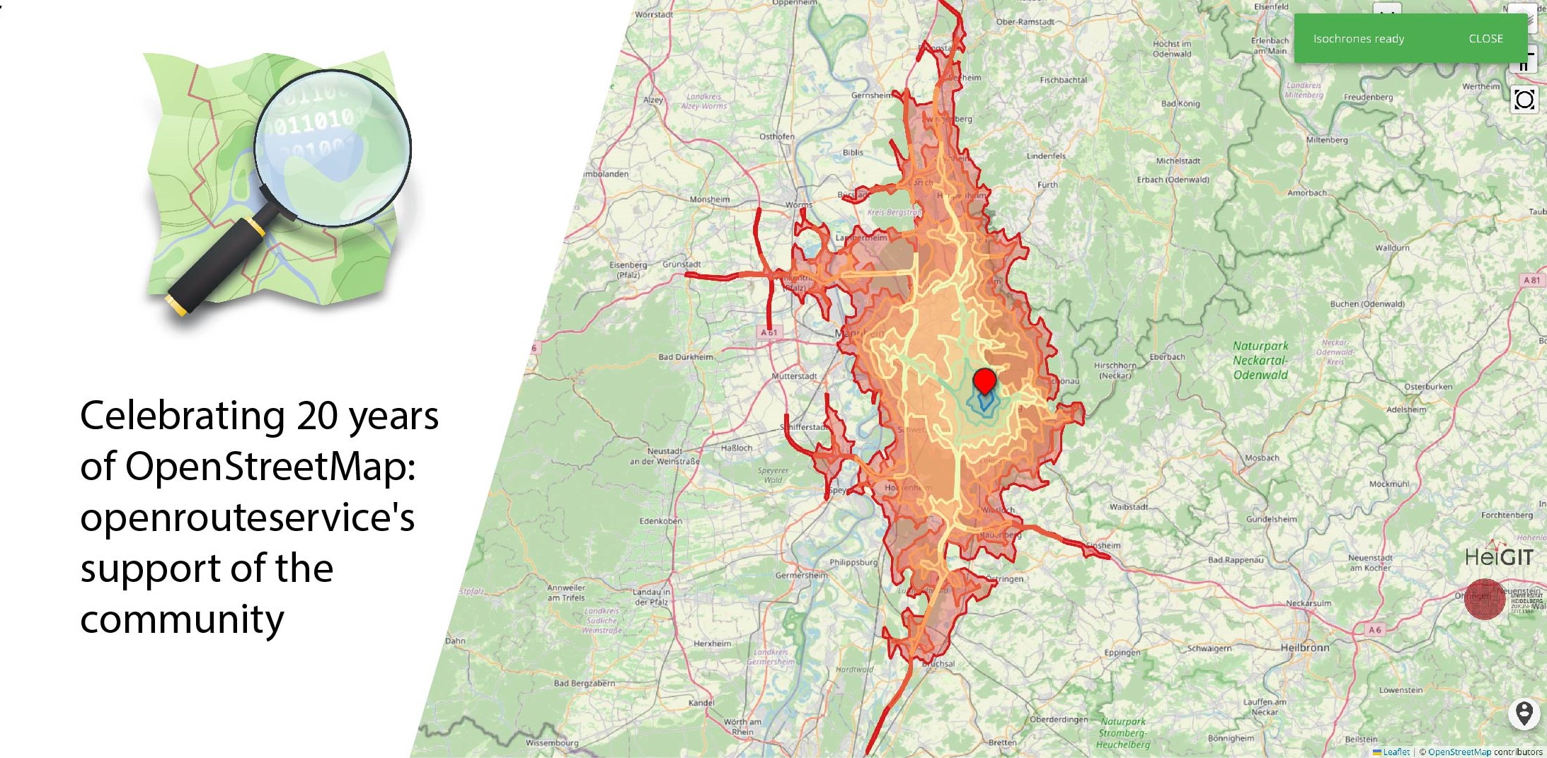
August 9 marks a turning point for the global mapping community: the 20th anniversary of OpenStreetMap (OSM). For two decades, OSM has revolutionized the way we perceive and interact with maps, transforming them from static representations to dynamic, community-driven resources. OpenStreetMap began as a visionary project aimed at creating a free, editable map of the world. What started as a small initiative has grown into a global movement with millions of contributors. These volunteers, rang...| GIScience Blog
HeiGIT and PLANUM, are happy to announce their cooperation in the field of climate action. PLANUM is committed to driving positive change through innovative engineering solutions. The company specializes in sustainable planning, making them a crucial partner in our pursuit of creating impactful and practical solutions to combat climate change.| GIScience Blog