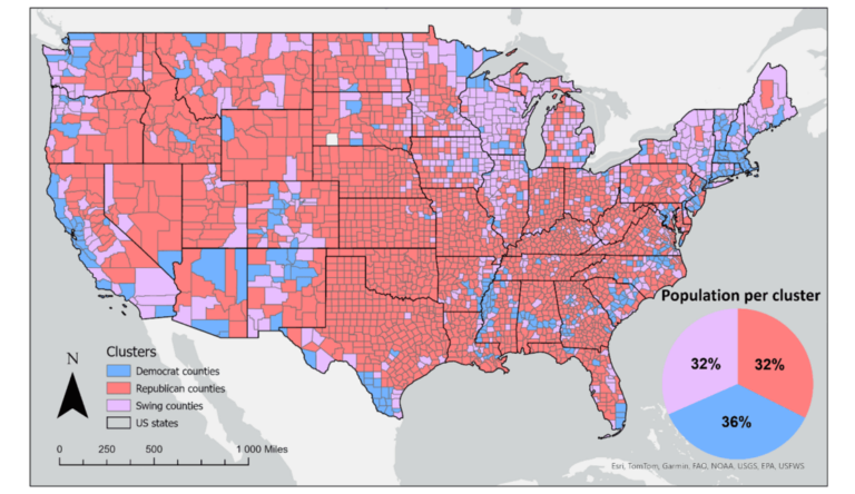
Acting Before the Disaster Happens: a Risk Assessment for Cyclones in Madagascar
Anticipatory Action for Disaster Management| HeiGIT
Overview| HeiGIT
Anticipatory Action for Disaster Management| HeiGIT
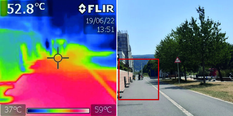
Crowdsourced street-level imagery can be used to detect and map humanitarian-relevant features in near real time. We have developed a machine-learning-based analytical pipeline that integrates with the open-source imagery catalogue Panoramax to support a more flexible disaster response and urban monitoring, especially in underserved regions. This blog article was originally posted on Medium by Macjej […]| HeiGIT
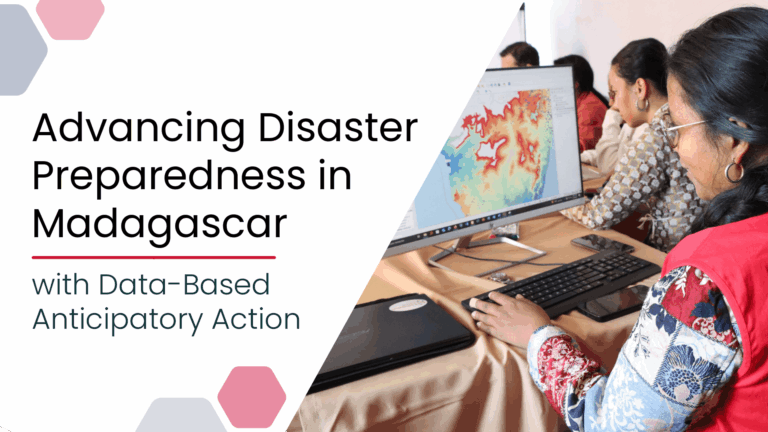
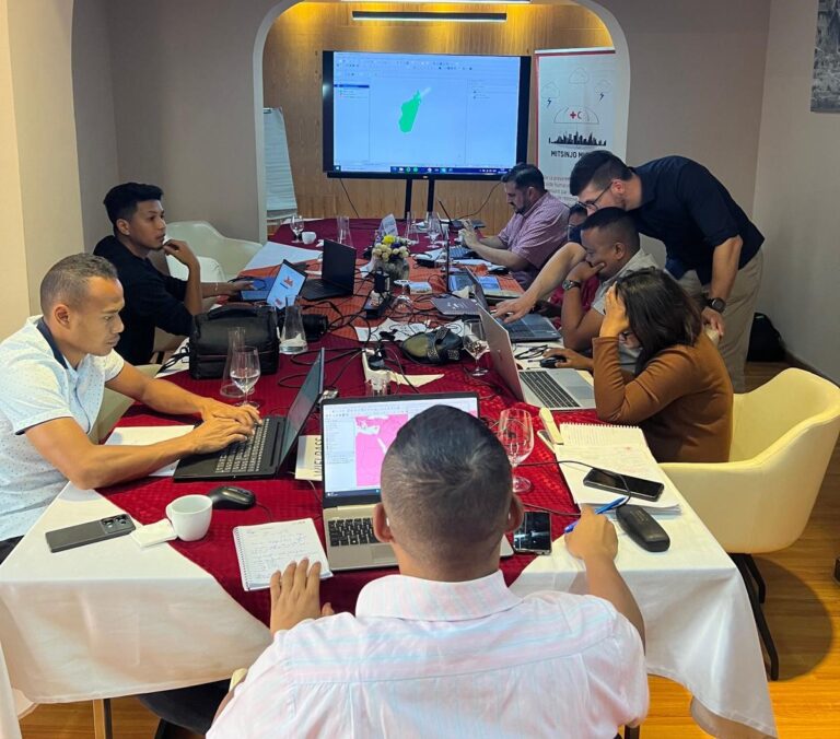
Anticipatory Action (AA) is becoming an increasingly vital approach in humanitarian and disaster risk management. By leveraging forecasts and risk data, AA enables timely interventions before extreme events occur. Geoinformation technologies play a key role in operationalizing this approach. In Madagascar, where cyclones regularly cause widespread damage, HeiGIT has been working with Croix-Rouge Malagasy (CRM, the Malagasy Red Cross) and the German Red Cross (GRC) and with the financial suppo...| HeiGIT
Open-source geoinformation, | heigit.org
Thanks to the newest addition to the Climate Action Navigator, it is now possible to calculate the remaining CO₂ budget for several German cities (Berlin, Bonn, Hamburg, Heidelberg, and Karlsruhe) to stay within certain global warming limits (e.g. +1,5°C). The CO₂ Budget assessment tool also tracks if the city is on the right track to […]| HeiGIT
Together with the German Federal Agency for Cartography and Geodesy (BKG) we released a new version of the ohsome dashboard, introducing a new indicator for assessing the thematic accuracy of land cover data in OpenStreetMap (OSM). This development is part of a broader project together with BKG on OSM data quality evaluation. New indicator: Thematic […]| HeiGIT
The ENHANCE project explores how 15-minute city principles can be applied beyond dense urban hubs, using mapping, behavioral research, and simulation tools to design more sustainable and inclusive mobility systems. The ENHANCE project, funded by Driving Urban Transitions to a Sustainable Future (DUT) under JPI Urban Europe, addresses the challenges of implementing 15-minute city (15mC) […]| HeiGIT
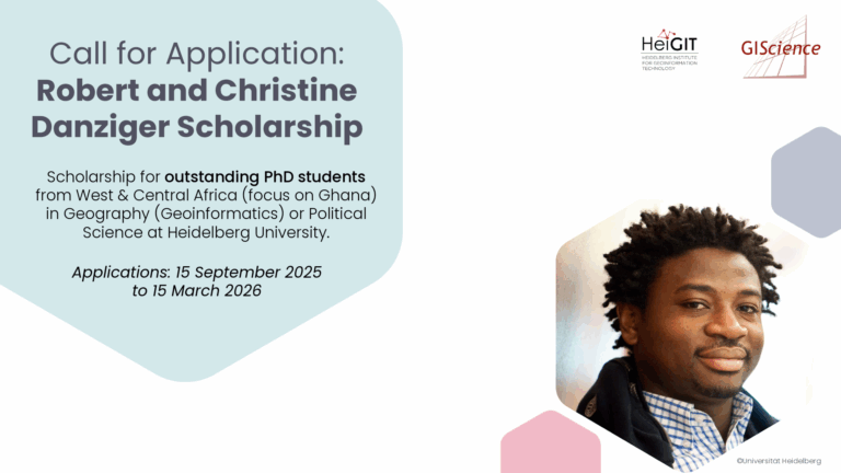
The Robert and Christine Danziger Scholarship supports outstanding doctoral students from West and Central Africa (with particular emphasis on applicants from Ghana), who intend to pursue a doctoral degree in Geography (specializing in Geoinformatics) or Political Science at Heidelberg University. Applicants are expected to be in the process of applying for a doctoral position at Heidelberg University and to be among the best in their research field.| HeiGIT
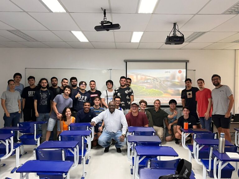
Building on ongoing efforts to enhance urban health management and mosquito-borne disease monitoring in the municipality of Rio de Janeiro, PhD candidate Steffen Knoblauch returned to the city for a second visit deepen collaborations and explore further applications of his research findings. He delivered lectures at several research institutions such as Universidade Federal do Rio de Janeiro (UFRJ), Instituto Nacional de Matemática Pura e Aplicada (IMPA), and Universidade Federal Fluminense ...| HeiGIT
In context of his research on mosquito monitoring and inner-urban dengue occurence, PhD student and GIScience team member Steffen Knoblauch visited the “Universidade Federal Fluminese” (UFF) in Niterói, State of Rio de Janeiro, Brazil. He was invited to meet collaborators and professors of UFF and to present his work in “Dengue Risk Modelling at an Urban Scale” as a guest lecturer. During his research, Steffen and his team had conducted a model experiment which shows how digital mo...| HeiGIT
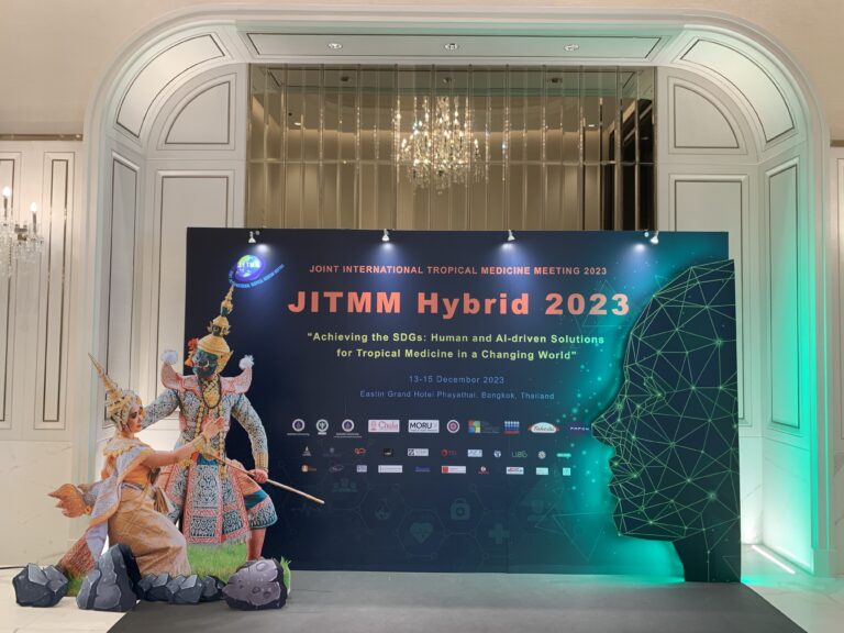
GIScience member and PhD candidate Steffen Knoblauch was invited as a speaker at the Joint Internationl Tropical Medicine Meeting (JITMM) 2023. The conference’s focal topic was “Achieving the SDGs: Human and AI-driven Solutions for Tropical Medicine in a Changing World” and it was hosted by the faculaty of Tropical Medicine, Mahidol University and co-organized by the Mahidol Oxford Tropical Medicine Research Unit (MORU). Taking place at the Eastin Grand Hotel Phayathai in Bangkok, Thail...| HeiGIT
This study develops a framework integrating satellite observations with spatial proxy data to produce high-resolution urban carbon emission maps. The method is applied to Urumqi, China, demonstrating accurate and timely estimations compared with traditional inventories. Reducing carbon emissions is a global priority, but conventional inventory methods based on administrative statistics fail to capture fine-scale spatial […]| HeiGIT
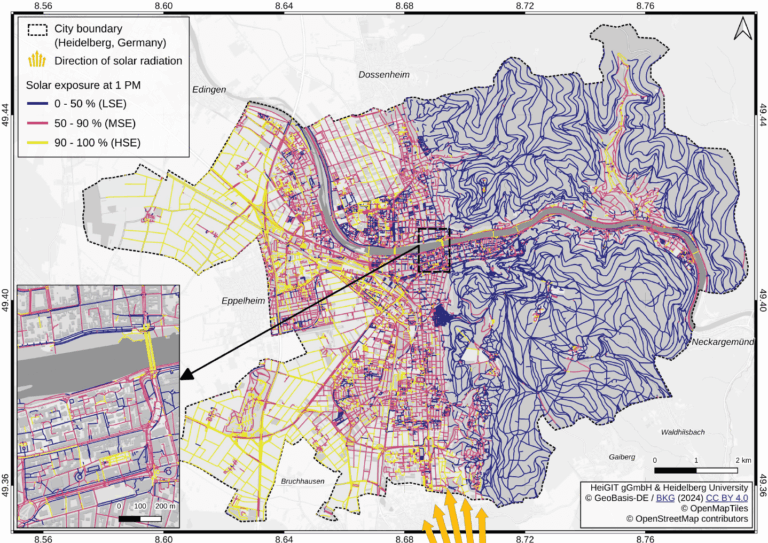
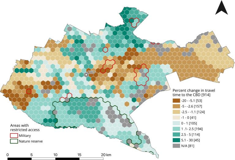
Using Heidelberg as a case study, researchers modeled time-dependent solar exposure for the entire pedestrian network by combining high-resolution DEM/DSM building and vegetation data with OpenStreetMap road data.| HeiGIT
Overview| HeiGIT
Overview| HeiGIT
The Sketch Map Tool was used in Cartagena, Chile, to collect geographic information for effective disaster risk reduction. It is an easy-to-use tool for participatory sketch mapping through offline collection, digitization and georeferencing of local spatial knowledge. The group mapping activity allows to identify issues associated with the risks that most concern and interests the […]| HeiGIT
Volunteered Geographic Information (VGI) is a valuable resource for an effective disaster management. This article presents five free tools to enhance humanitarian work using VGI. What is VGI and why it matters for disaster management Volunteered Geographic Information (VGI) refers to user-generated geographic content contributed voluntarily by the public. It represents a form of crowdsourcing […]| HeiGIT
This study evaluates the applicability of macro-scale energy poverty indices in an urban context, using Santiago de Chile as a case study. Energy poverty (EP), understood as the inability of a household to meet its basic energy needs, is a global challenge exacerbated by rising energy prices, inflation, and economic instability. Accelerated urbanization and climate […]| HeiGIT
This blog post introduces a step-by-step tutorial for working with a global road surface dataset. Using open-source tools, the tutorial demonstrates how to identify infrastructure gaps by combining road surface data with population information. How much time does a humanitarian mission need to reach a remote village after a cyclone hits rural Madagascar? How fast […]| HeiGIT
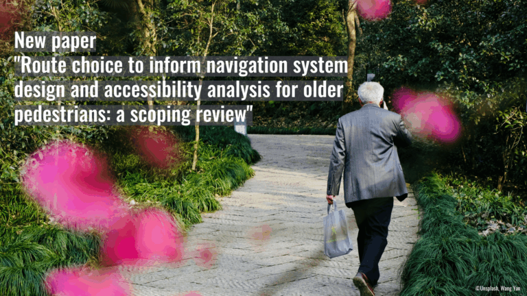
Walking supports healthy aging, but older adults often prioritize safety and comfort over speed. This study uses a scoping review to examine these preferences and guide age-inclusive routing systems.| HeiGIT
%7B%22status%22%3A%22success%22%2C%22updateneeded%22%3Afalse%2C%22instance%22%3Afalse%2C%22meta%22%3A%7B%22request_last%22%3A0%2C%22request_next%22%3A0%2C%22used_cache%22%3Atrue%7D%2C%22data%22%3A%5B%7B%22key%22%3A%22UEEGL68Q%22%2C%22library%22%3A%7B%22id%22%3A5612809%7D%2C%22meta%22%3A%7B%22creatorSummary%22%3A%22von%20Elverfeldt%20et%20al.%22%2C%22parsedDate%22%3A%222025%22%2C%22numChildren%22%3A0%7D%2C%22bib%22%3A%22%26lt%3Bdiv%20class%3D%26quot%3Bcsl-bib-body%26quot%3B%20style%3D%26quot%3...| HeiGIT
The Silver Ways project aims to make footpaths in Mannheim more suitable for senior citizens. An ongoing survey is collecting the experiences of elderly pedestrians. The goal is to improve everyday mobility. Your point of view is important: participate to the survey now! Many older people depend on easily accessible and safe footpaths in their […]| HeiGIT
As summer temperatures soar, being outdoors poses rising health risks, especially in urban areas and for vulnerable groups like the elderly, children, and citizen with pre-existing conditions. The HEAL project launched a routing app to help citizens avoid heat stress, supporting climate adaptation and public health during hot weather periods. Initially developed for Heidelberg, the […]| HeiGIT
In June 2024, researchers from the Urban Big Data Centre (UBDC) and HeiGIT (Heidelberg Institute for Geoinformation Technology) carried out a joint field trip to Colombia to strengthen participatory mapping collaborations. The visit included workshops, partner meetings, and field activities with communities, universities, and government institutions, with a focus on the use and development of […]| HeiGIT
The ohsomeNow Stats dashboard has been updated to enhance its visual and functional elements. This facilitates the exploration of OpenstreetMap (OSM) mapping activities across space and time. New H3 hexagon maps at high and low resolution One of the most notable improvements is the new mapping interface. Previously, country-level visualizations were limited and lacked spatial […]| HeiGIT
As part of our ongoing work in Anticipatory Action, a QGIS plugin for risk assessments was developed with the goal of enabling local actors to carry out risk assessments independently and reliably. The tool builds on HeiGIT’s broader efforts to support community resilience by making geoinformation technology more accessible to practitioners in diverse operational contexts. […]| HeiGIT
The Sketch Map Tool was used in a joint effort between the Honduran Red Cross and the municipal government to update the municipal response plan and develop an annex focused on anticipatory actions. Participants were asked to map local knowledge about areas affected by flooding and critical infrastructure. The Sketch Map Tool was used during […]| HeiGIT
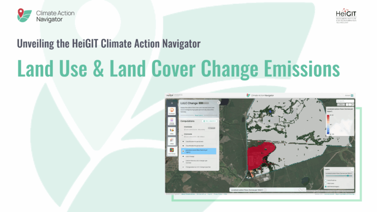
The Climate Action Navigator (CAN) is HeiGIT’s interactive dashboard offering high-resolution data and key climate indicators, ranging from the quality and availability of mobility infrastructure to CO2 emissions from heating of residential buildings.| HeiGIT
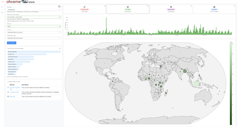
OhsomeNow stats makes it possible to monitor contributions to OpenStreetMap (OSM) in real time. We developed this new dashboard as part of our long-term cooperation with the Humanitarian OpenStreetMap Team (HOT), an international organization dedicated to humanitarian action and community development through open mapping. This dashboard has replaced the Missing Maps Leaderboard with a comprehensive overview of how much mapping takes place at certain mapping events and campaigns. With version...| HeiGIT
Overview| HeiGIT
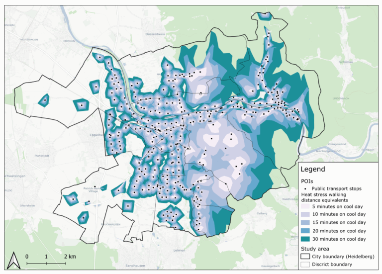
This study introduces the isocalor approach to assess how solar exposure and heat stress impact pedestrian access to essential services in Heidelberg, using OpenStreetMap data and a customized openrouteservice routing engine.| HeiGIT
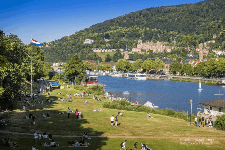
Before coming to Heidelberg he led the Chair of Cartography at Bonn University and earlier was Professor for Applied Computer Science and Geoinformatics at the University of Applied Sciences in Mainz, Germany. He has a background in Mathematics and Geography from Heidelberg University and finished his PHD at the European Media Laboratory EML in Heidelberg where he was the first PhD student. There he also conducted further research as a PostDoc for 3 years.| HeiGIT
Free geoinformation, methods and software for the benefit of the environment and society.| HeiGIT
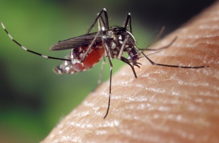
On December 18, 2024, GIScience PhD candidate Steffen Knoblauch will present his research on “Habitat-Scale Environmental Suitability Mapping for Aedes aegypti.” The public lecture will take place at 9:00 AM in the Conference Room, 5th Floor, Mathematikon, Im Neuenheimer Feld 205, 69120 Heidelberg, and will be followed by a non-public PhD defense examination.| HeiGIT
The novel coronavirus disease (COVID-19) generated significant health concerns worldwide, leading policymakers and health care experts to implement nonpharmaceutical public health interventions to mitigate the spread of the virus. While these interventions played a crucial role in controlling transmission, they also resulted in substantial economic and societal costs, necessitating strategic deployment, particularly during periods of increasing disease activity. In this context, geosocial med...| HeiGIT
Students of the Institute of Geography at Heidelberg University explored local perceptions of urban heat in Heidelberg’s old town as part of a 2024 seminar on GIS for Disaster Risk Reduction and Humanitarian Aid. The project, supported by Heidelberg Institute for Geoinformation Technology (HeiGIT), tested participatory mapping using the Sketch Map Tool combined with KoboToolbox.| HeiGIT

This project explores how OpenStreetMap data can complement satellite imagery for tracking land cover changes in Germany. Using a small test area, we compare datasets over time to better understand how real-world changes are reflected in OSM—and how this knowledge can support automated monitoring.| HeiGIT
This study, published at African Transport Studies, investigates the impact of school sessions on traffic congestion in Nairobi, highlighting how children’s mobility needs are often overlooked in transport planning.| HeiGIT
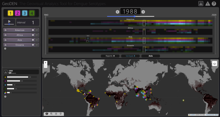
With the increasing availability of global disease datasets, Visual Analytics (VA) has emerged as a valuable tool in spatial epidemiology, particularly for studying serotype interactions in diseases like dengue. Dengue, caused by four serotypes (DENV1-DENV4), poses a significant global health threat exacerbated by urbanization and climate change. Traditional approaches rely on static mapping or animation of serotype incidence, but there remains a gap in utilizing VA tools for dynamic and inte...| HeiGIT
Overview| HeiGIT
We are pleased that you wish to apply for a job with us. In the following, we would like to explain how we process the personal data you provide to us as part of the application process.| HeiGIT
Natural hazards threaten millions of people all over the world. To address this risk, exposure and vulnerability models with high resolution data are essential. However, in many areas of the world, exposure models are rather coarse and are aggregated over large areas. Although OpenStreetMap (OSM) offers great potential to assess risk at a detailed building-by-building level, the completeness of OSM building footprints is still heterogeneous. Therefore, in our recent paper we developed tools a...| Heidelberg Institute for Geoinformation Technology
Strengthening humanitarian efforts with the German Red Cross| Heidelberg Institute for Geoinformation Technology
Openrouteservice for Disaster Management| Heidelberg Institute for Geoinformation Technology
Geoinformation for Humanitarian Aid| Heidelberg Institute for Geoinformation Technology
Big Spatial Data Analytics| Heidelberg Institute for Geoinformation Technology
The research team of the transdisciplinary project HEAL (Heat Adaptation for Vulnerable Population Groups), focusing on providing heat adaptation measures for vulnerable groups in Heidelberg, has published a research paper titled “How to assess the needs of vulnerable population groups towards heat-sensitive routing? An evidence-based and practical approach to reducing urban heat stress”. The paper delves into the comprehensive methodologies employed to understand local heat stress and id...| HeiGIT
Free geoinformation, methods and software for the benefit of the environment and society.| HeiGIT
