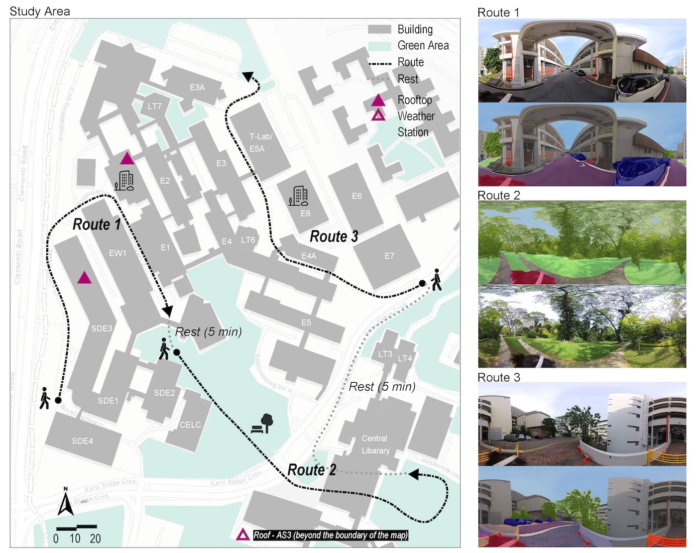
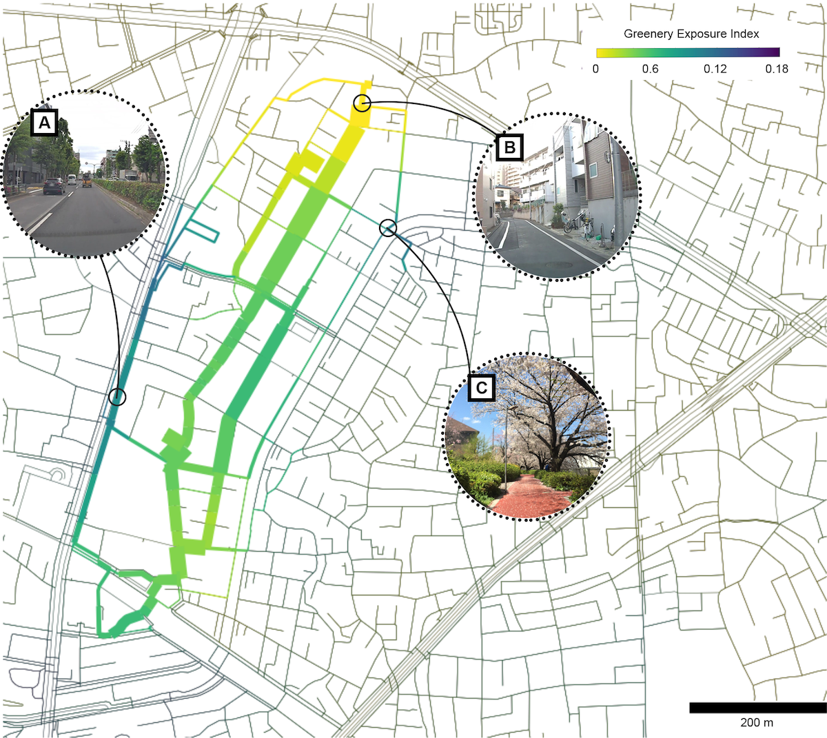
Urban environments are increasingly recognised for their potential to support psychological restoration, yet most studies assess green and grey spaces in isolation and rely on static, lab-based measures. This study introduces a multi-layered analytical framework that integrates experimental walking, momentary perception tracking, and machine learning to investigate how multisensory urban features shape restoration. Conducted on a university campus, the experiment exposed 20 participants to se...| Urban Analytics Lab | Singapore
Adopting 3D City Index, a comprehensive 3D data scoring framework encompassing four categories—data portals, model descriptions, thematic content, and semantic information, we assess and benchmark currently available 3D city models made accessible openly by governments worldwide. The 2025 update, including 47 datasets, reveals both the current situation and advancements in the open 3D data landscape since the previous benchmark 3 years ago. The heterogeneous landscape continues, with Europe...| Urban Analytics Lab | Singapore
Despite recent advancements in surface reconstruction, Level of Detail (LoD) 3 building reconstruction remains an unresolved challenge. The main issue pertains to the object-oriented modelling paradigm, which requires georeferencing, watertight geometry, facade semantics, low-poly representation, and starkly contrasting unstructured mesh-oriented models. In Texture2LoD3, we introduce a novel method leveraging the ubiquity of 3D building model priors and panoramic street-level images, enabling...| Urban Analytics Lab | Singapore
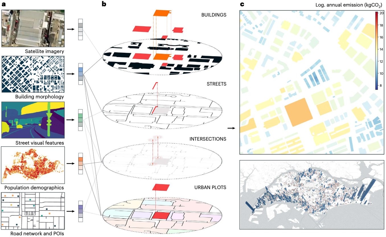
Achieving carbon neutrality is a critical yet elusive goal for many cities, hindered by limited understanding of the relationship between building emissions and their surroundings. To address this challenge, we present a generalizable open science framework that integrates building energy-consumption data, multi-modal geospatial inputs and graph deep learning to quantify building operating emissions and their links to urban form and socio-economic factors. Applying this approach to five citie...| Urban Analytics Lab | Singapore
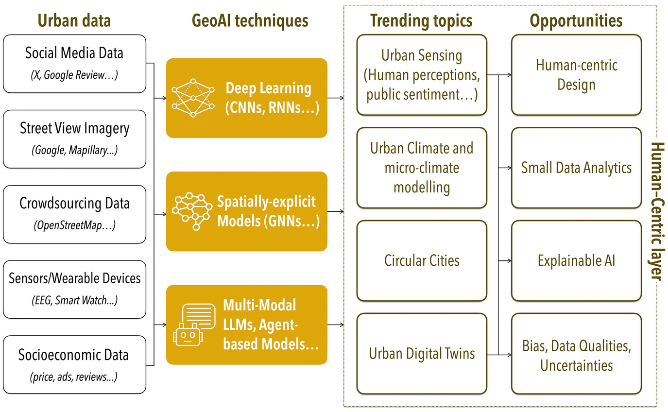
Recognising GeoAI as an emerging and rapidly evolving field that has been increasingly adopted in urban geography, this chapter provides an overarching overview of the GeoAI methods for urban analytics. It begins by revisiting the theoretical underpinnings of urban theory and mapping the evolution of urban spatial analytics, tracing the journey from traditional statistical methods to the cutting-edge AI-driven approaches reshaping the discipline today. Beyond examining the current state of Ge...| Urban Analytics Lab | Singapore
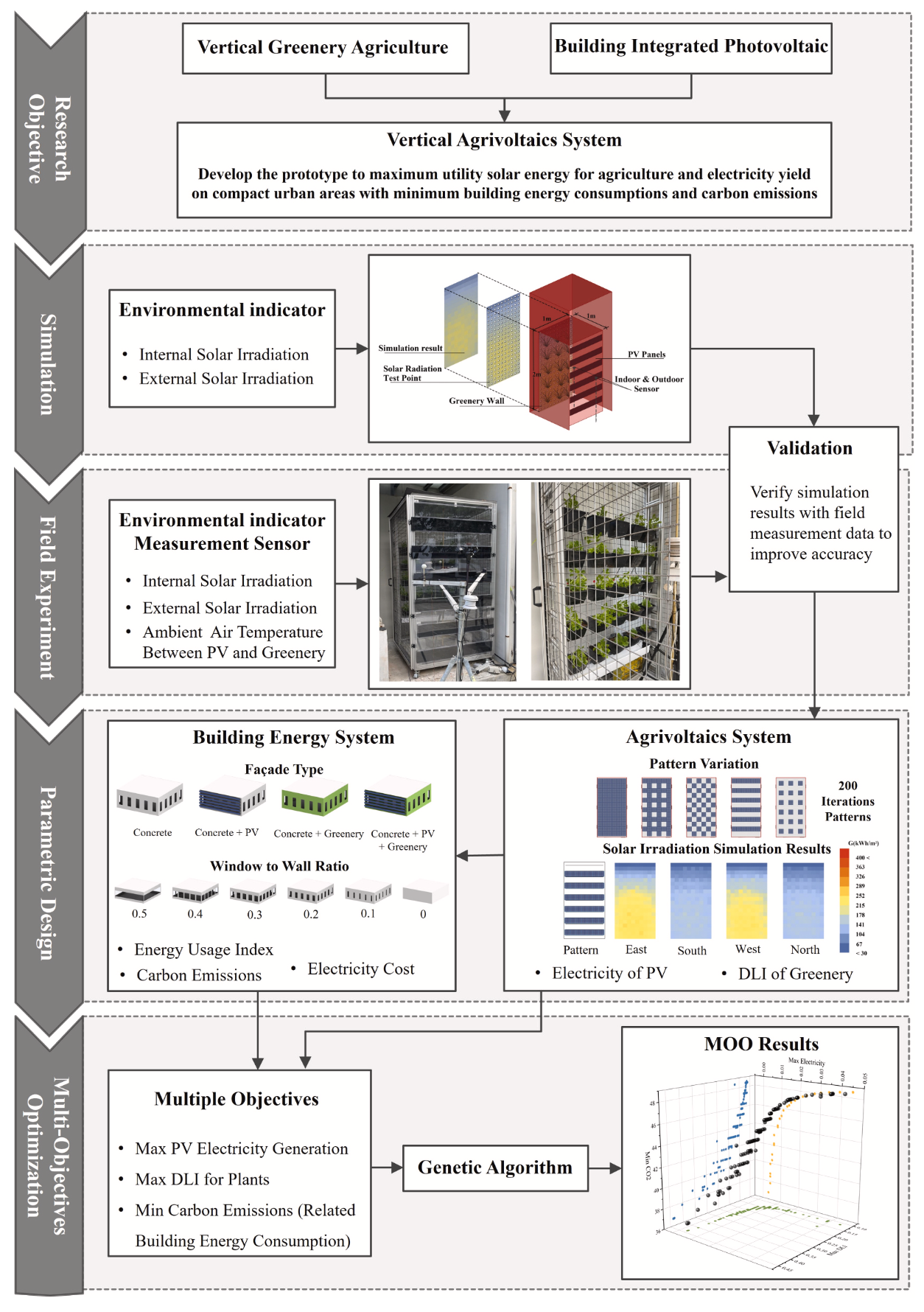
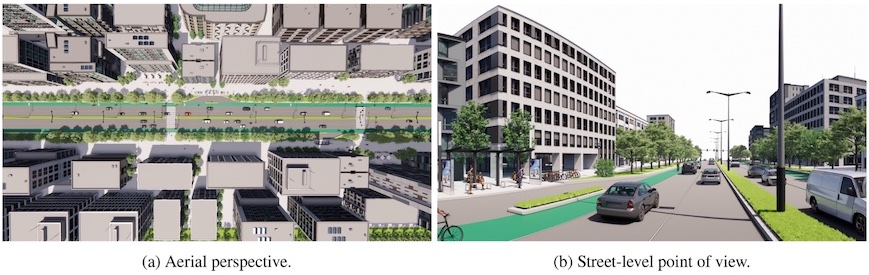
Climate change and urbanization present critical challenges to cities, requiring innovative energy and food security strategies. This study introduces a novel agrivoltaic system for building façades in Singapore’s dense urban context, addressing the trade-off between photovoltaic (PV) electricity generation and plant growth under shared solar exposure. By combining field experiments and advanced simulations, a genetic algorithm was employed to optimize PV arrangements, balancing solar expo...| Urban Analytics Lab | Singapore
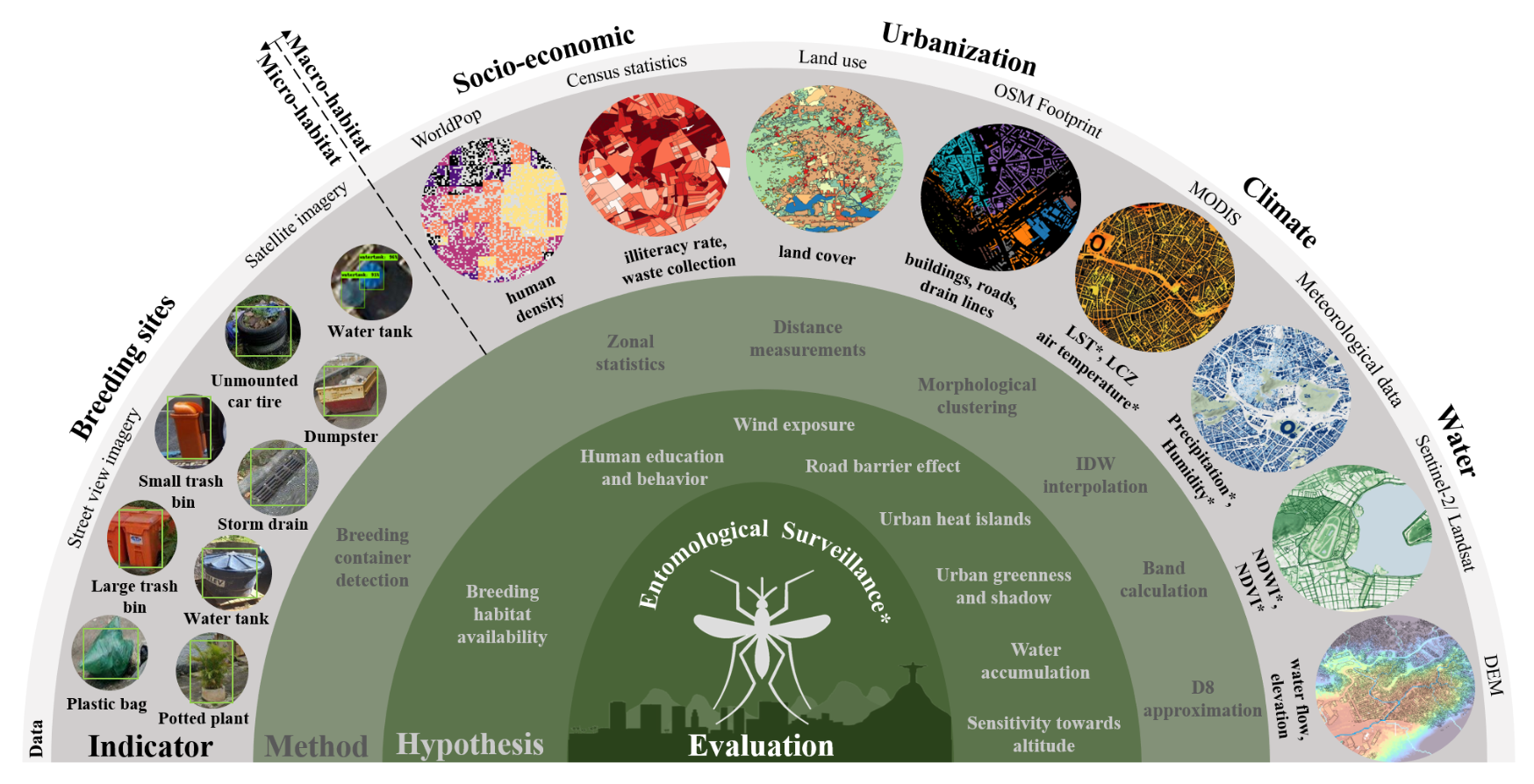
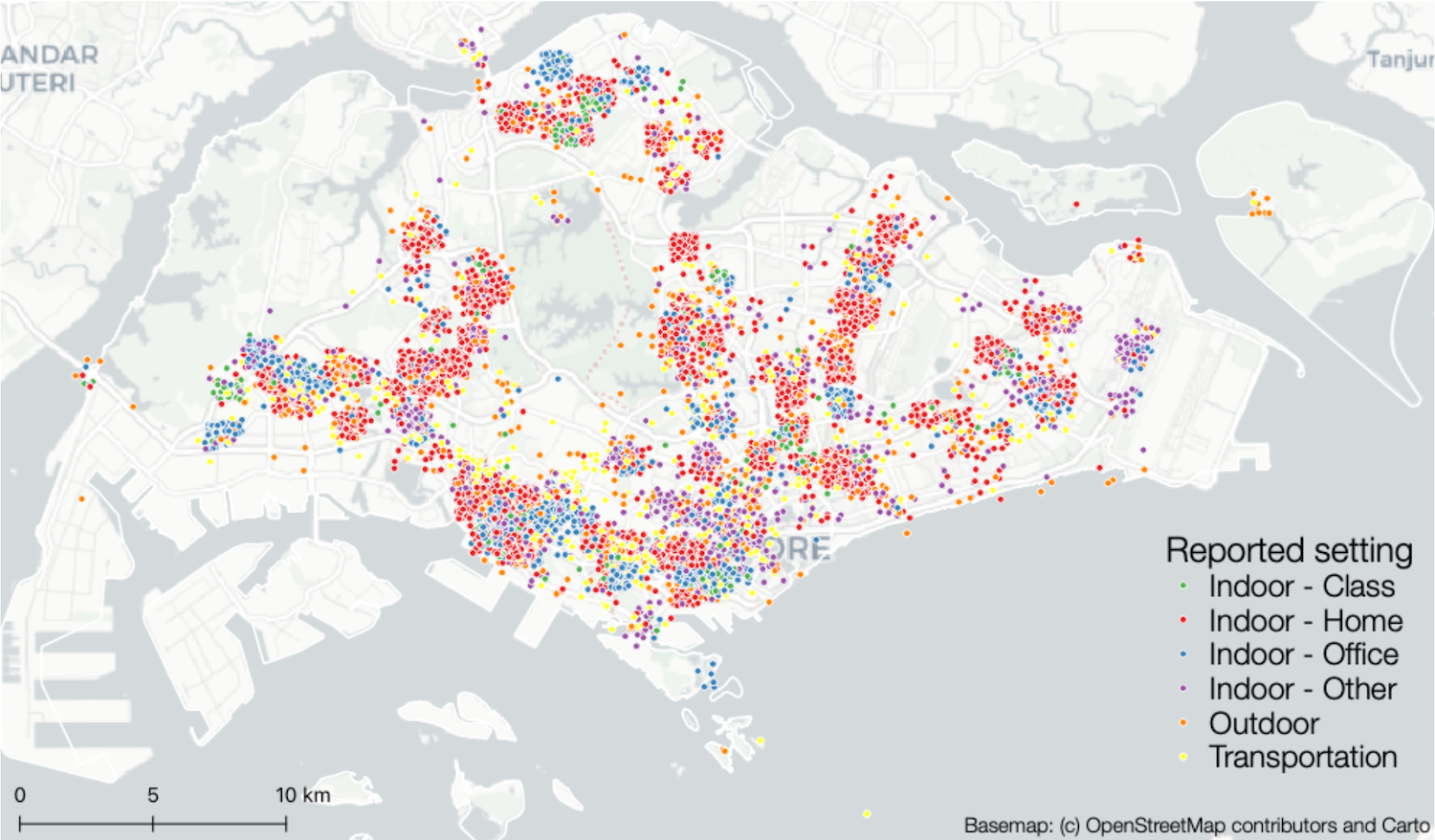
Background Controlling Aedes aegypti stands as the primary strategy in curtailing the global threat of vector-borne viral infections such as dengue fever, which is responsible for around 400 million infections and 40 000 fatalities annually. Effective interventions require a precise understanding of Ae aegypti spatiotemporal distribution and behaviour, particularly in urban settings where most infections occur. However, conventionally applied sample-based entomological surveillance systems ...| Urban Analytics Lab | Singapore
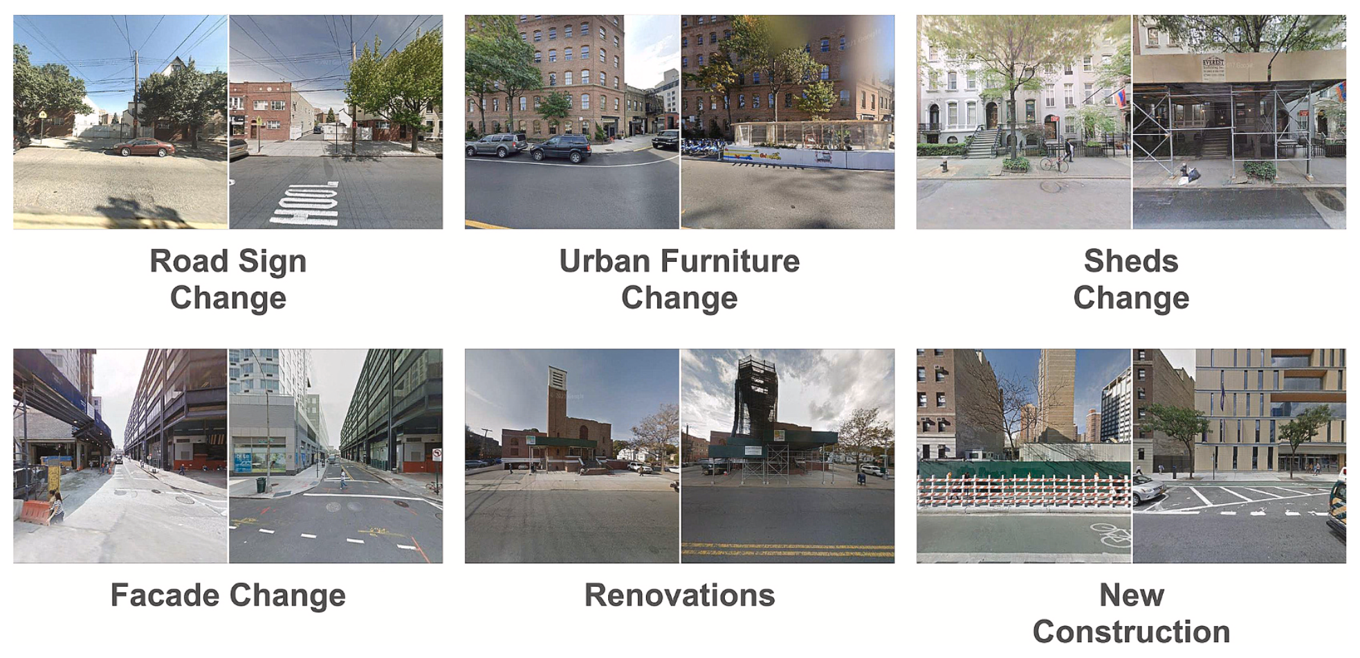
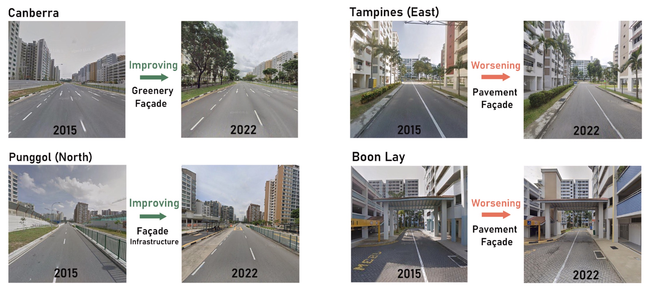
Urban transformation not only reshapes physical spaces but also impacts public perception, influencing how people experience their environments. This study utilizes Street View Imagery (SVI) as an emerging, human-level data source to assess urban changes, providing perspective beyond traditional datasets. Existing studies often focus on either urban physical changes or human perception changes, without bridging the two. This research integrates both aspects by combining a change detection mod...| Urban Analytics Lab | Singapore
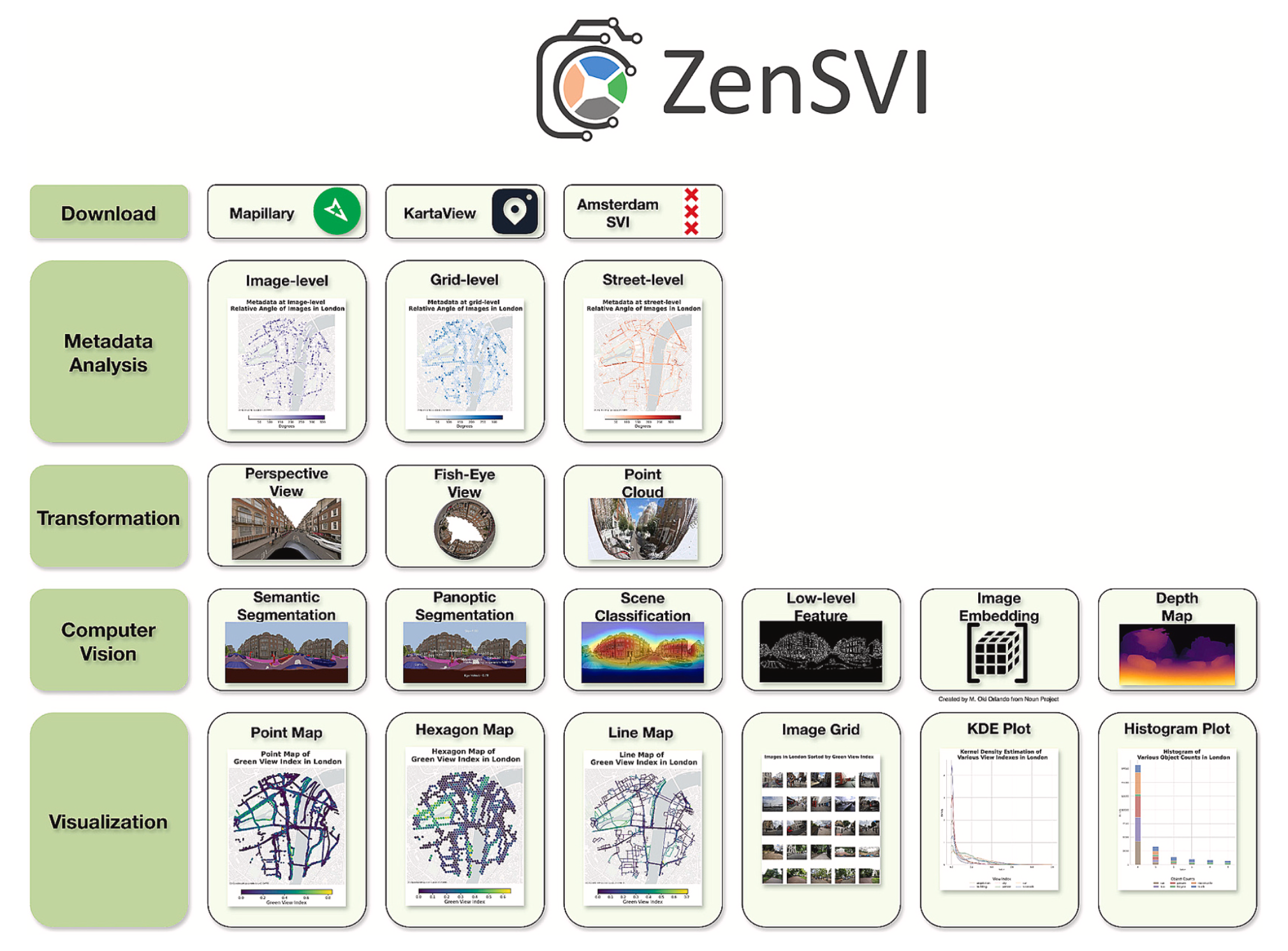
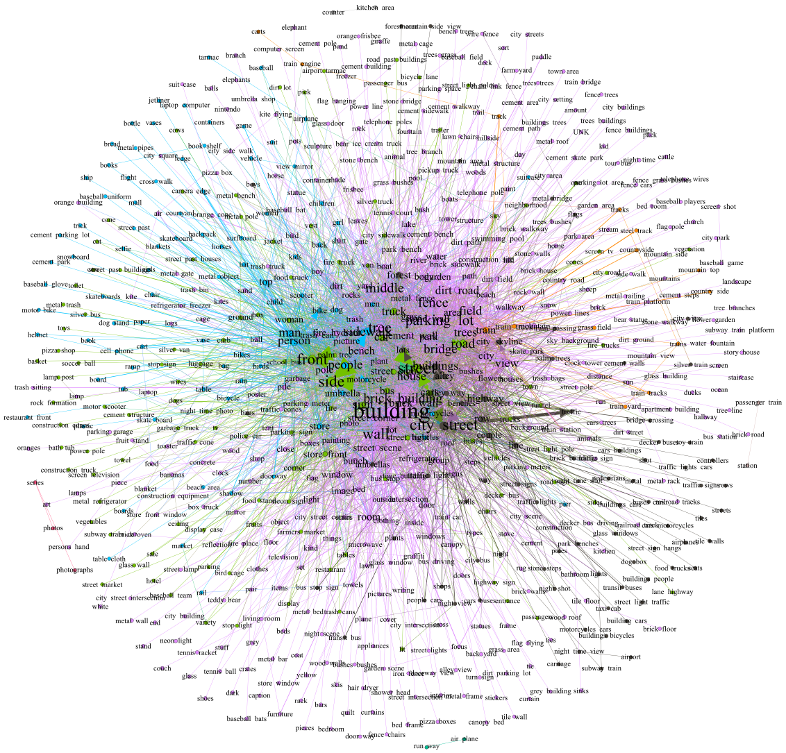
Street view imagery (SVI) has been instrumental in many studies in the past decade to understand and characterize street features and the built environment. Researchers across a variety of domains, such as transportation, health, architecture, human perception, and infrastructure have employed different methods to analyze SVI. However, these applications and image-processing procedures have not been standardized, and solutions have been implemented in isolation, often making it difficult for ...| Urban Analytics Lab | Singapore
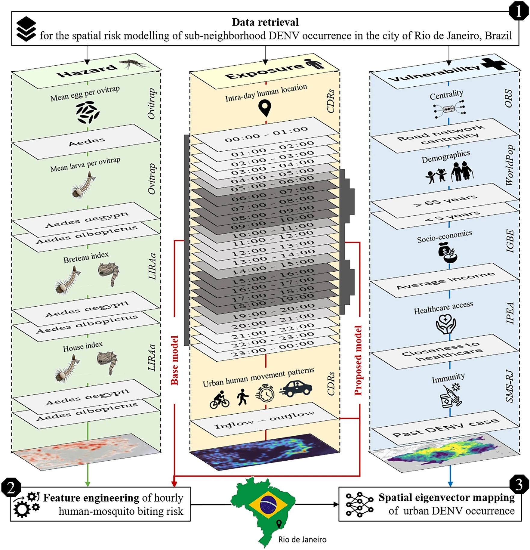
Cities are the hot spots for global dengue transmission. The increasing availability of human movement data obtained from mobile devices presents a substantial opportunity to address this prevailing public health challenge. Leveraging mobile phone data to guide vector control can be relevant for numerous mosquito-borne diseases, where the influence of human commuting patterns impacts not only the dissemination of pathogens but also the daytime exposure to vectors. This study utilizes hourly m...| Urban Analytics Lab | Singapore
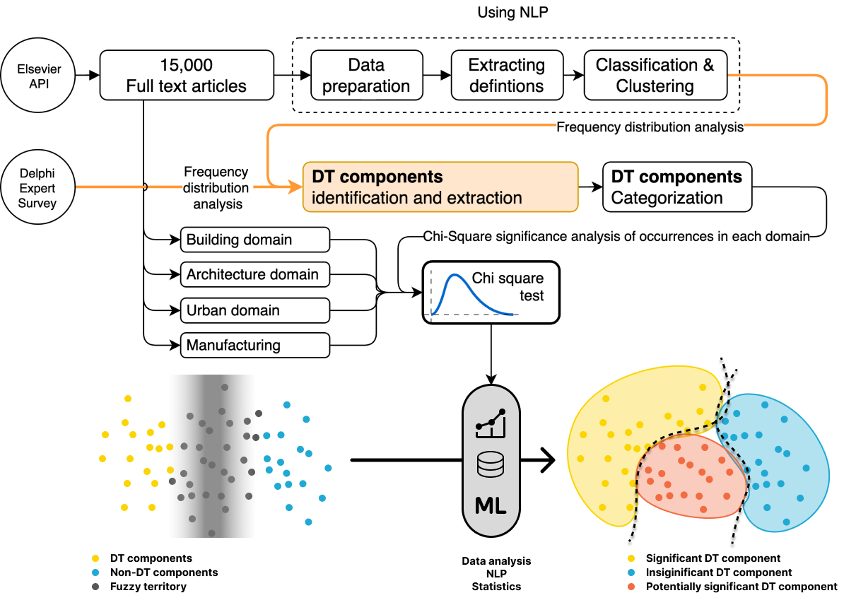
The concept of Digital Twins (DT) has attracted significant attention across various domains, particularly within the built environment. However, there is a sheer volume of definitions and the terminological consensus remains out of reach. The lack of a universally accepted definition leads to ambiguities in their conceptualization and implementation, and may cause miscommunication for both researchers and practitioners. We employed Natural Language Processing (NLP) techniques to systematical...| Urban Analytics Lab | Singapore
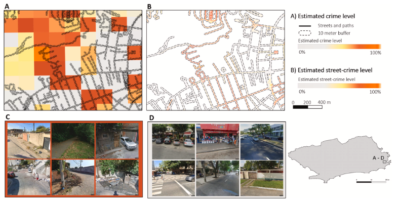
Education is a fundamental right, supported by initiatives like Education for All (EFA) and the Millennium Development Goals (MDGs). Despite progress, full educational access remains challenging, particularly in highly criminal areas. This paper examines the impact of crime on school access in the municipality of Rio de Janeiro. Using ancillary data and geospatial artificial intelligence (GeoAI), we downscaled official police crime records to street level. By considering different levels of c...| Urban Analytics Lab | Singapore
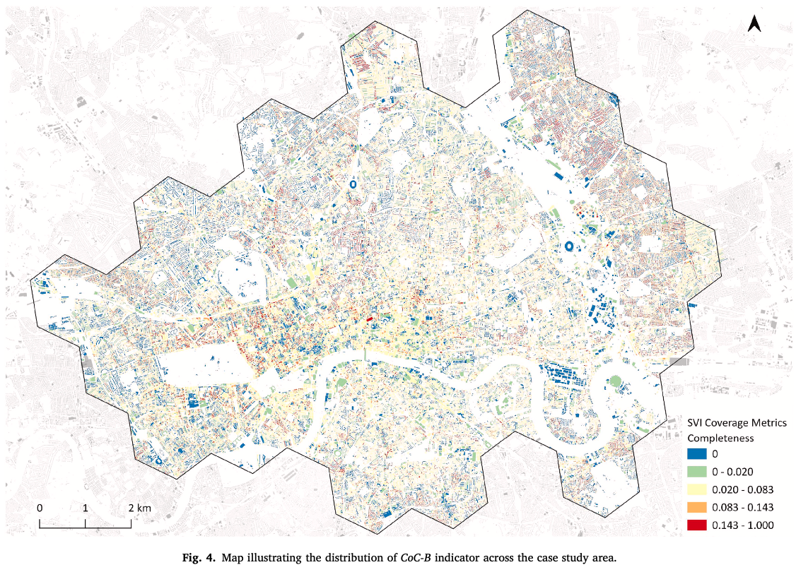
Street View Imagery (SVI) has emerged as a valuable data form in urban studies, enabling new ways to map and sense urban environments. However, fundamental concerns regarding the representativeness, quality, and reliability of SVI remain underexplored, e.g. to what extent can cities be captured by such data and do data gaps result in bias. This research, positioned at the intersection of spatial data quality and urban analytics, addresses these concerns by proposing a novel and effective meth...| Urban Analytics Lab | Singapore
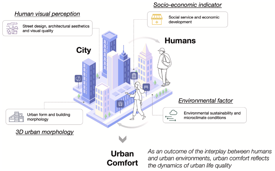
Urban comfort is a means of measuring the dynamic quality of urban life as an outcome of the interaction between humans and urban environments, capturing spatio-temporal phenomena in cities. We design a multidimensional urban comfort framework encompassing 44 features, to comprehensively represent urban living environments, based on 3D urban morphology, socio-economic features, human perception, and environmental factors. We develop a graph-based approach to measure urban comfort through an i...| Urban Analytics Lab | Singapore
Transitions of spatial data infrastructures (SDIs) support applications from 2D landscapes to 3D scenes. The existing methods for describing, managing, and providing services for 3D spatial data often lack coordination and efficiency. Moreover, the added complexity of 3D data structures necessitates novel approaches for component-level management and streaming capabilities. In response, we developed a generic conceptual model suitable for component-level management of diverse 3D spatial data ...| Urban Analytics Lab | Singapore
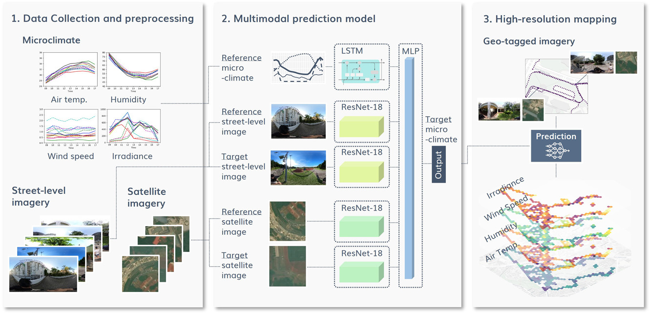
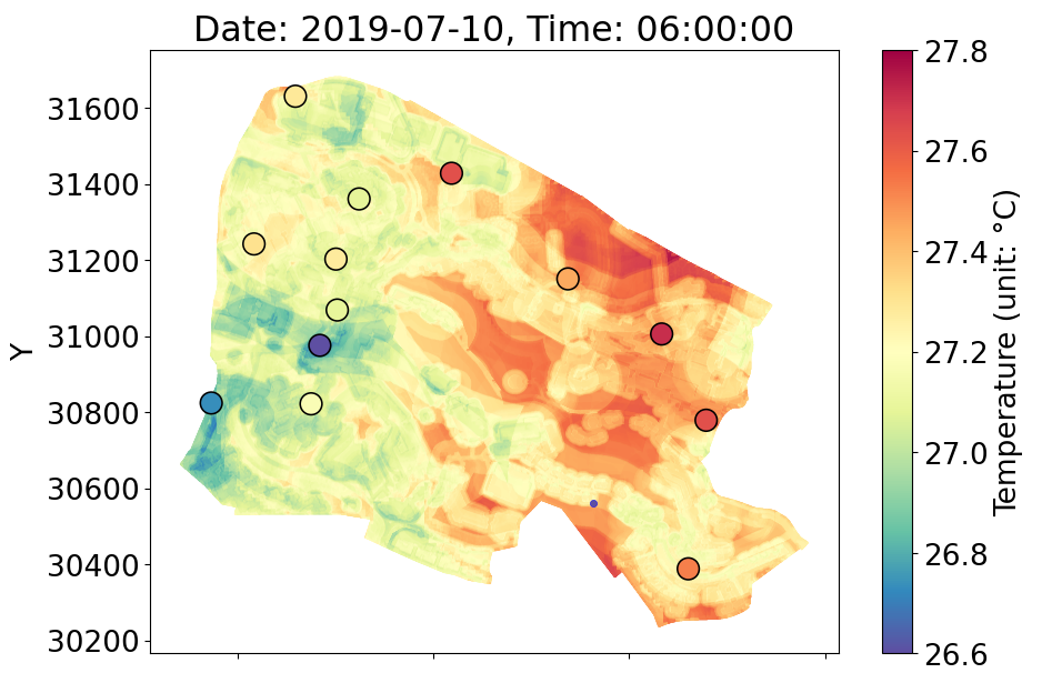
High-resolution microclimate data is essential for capturing spatio-temporal heterogeneity of urban climate and heat health management. However, previous studies have relied on dense measurements that require significant costs for equipment, or on physical simulations demanding intensive computational loads. As a potential alternative to these methods, we propose a multimodal deep learning model to predict microclimate at a high spatial and temporal resolution based on street-level and satell...| Urban Analytics Lab | Singapore
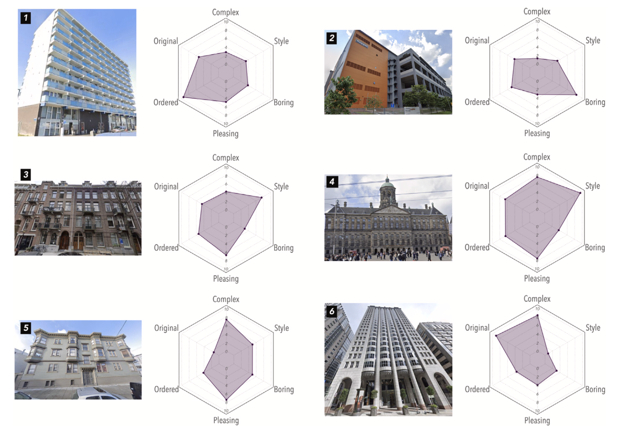
Building appearances profoundly shape the urban visual landscape, influencing city images and the quality of urban life. Traditional methods for evaluating the perceptual and aesthetic qualities of building facades are often limited in scope. Despite recent studies that have sought to understand human perception of urban streetscapes, our grasp of how individuals perceive building exteriors on a broader scale and the subsequent impact on holistic street experiences, remains largely unexplored...| Urban Analytics Lab | Singapore
Street view imagery (SVI) is instrumental for sensing urban environments, benefitting numerous domains such as urban morphology, health, greenery, and accessibility. Billions of images worldwide have been made available by commercial services such as Google Street View and crowdsourcing services such as Mapillary and KartaView where anyone from anywhere can upload imagery while moving. However, while the data tend to be plentiful, have high coverage and quality, and are used to derive rich in...| Urban Analytics Lab | Singapore
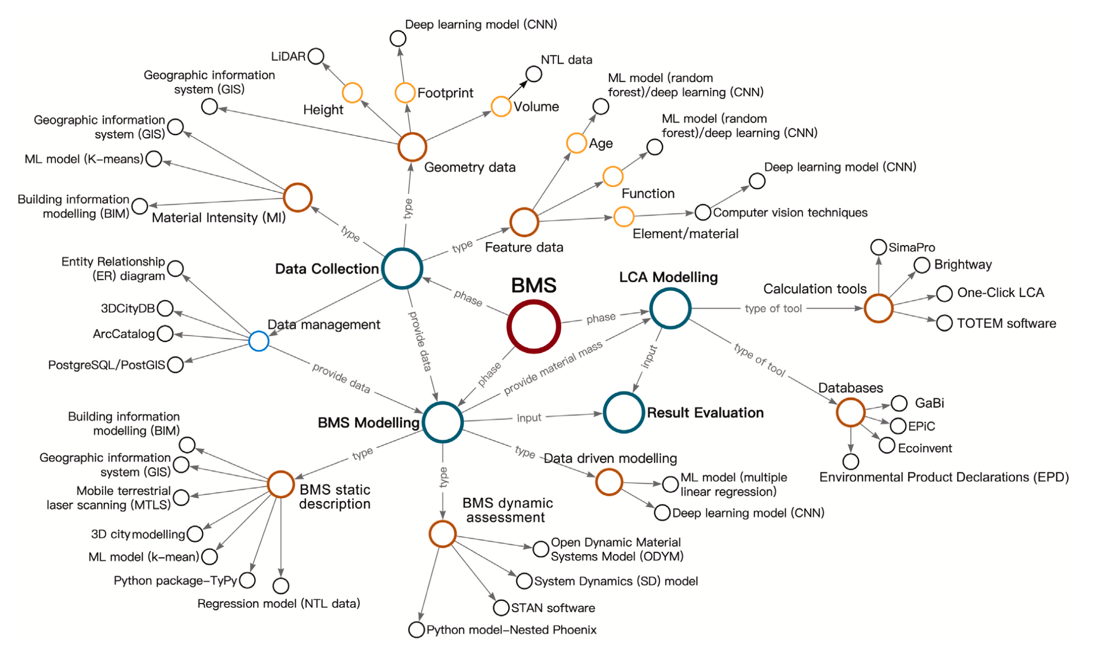
The urban building stock has a high demand for materials and energy, exerting tremendous pressure on natural resources. A current research trend is to integrate Building Material Stock (BMS) analysis with Life Cycle Assessment (LCA) to evaluate energy use, material stock/flows, and related environmental performance associated with the life cycle of building stocks. Compared with urban building energy modelling (UBEM), material-related analysis is a relatively new topic. Some studies applied n...| Urban Analytics Lab | Singapore
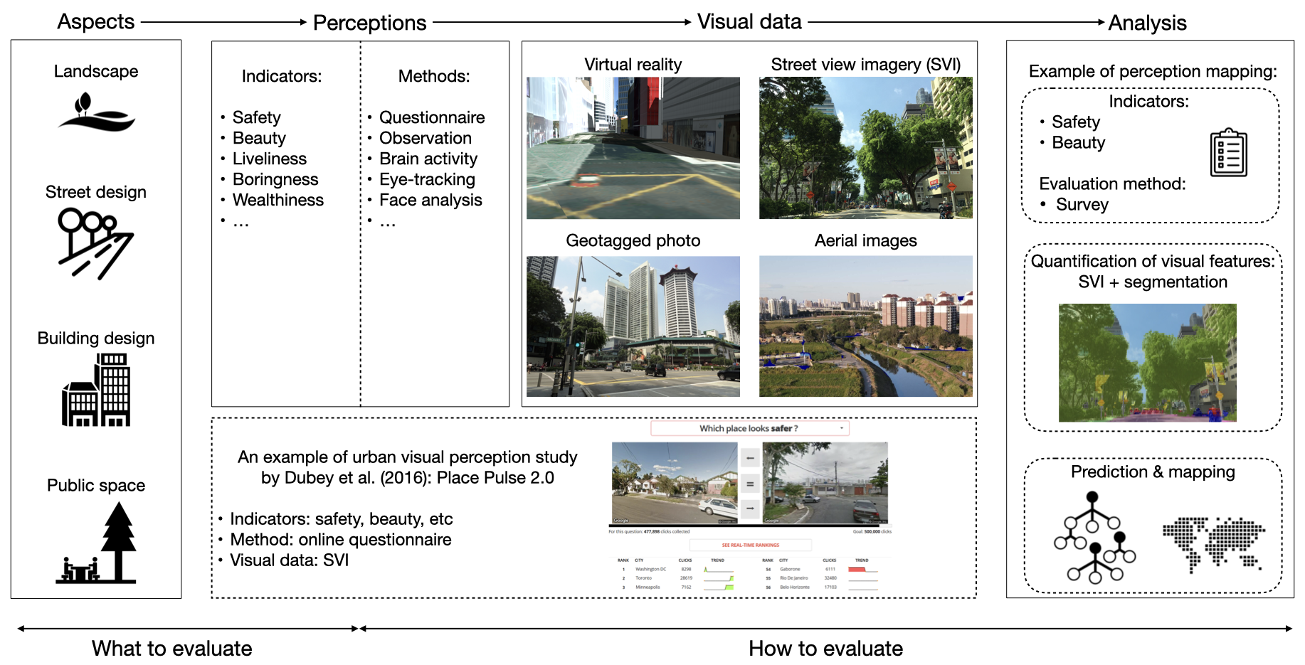
Visual characteristics of the built environment affect how people perceive and experience cities. For a long time, many studies have examined visual perception in cities. Such efforts have accelerated in recent years due to advancements in technologies and the proliferation of relevant data (e.g., street view imagery, geo-tagged photos, videos, virtual reality, and aerial imagery). There has not been a comprehensive systematic review paper on this topic to reveal an overarching set of researc...| Urban Analytics Lab | Singapore
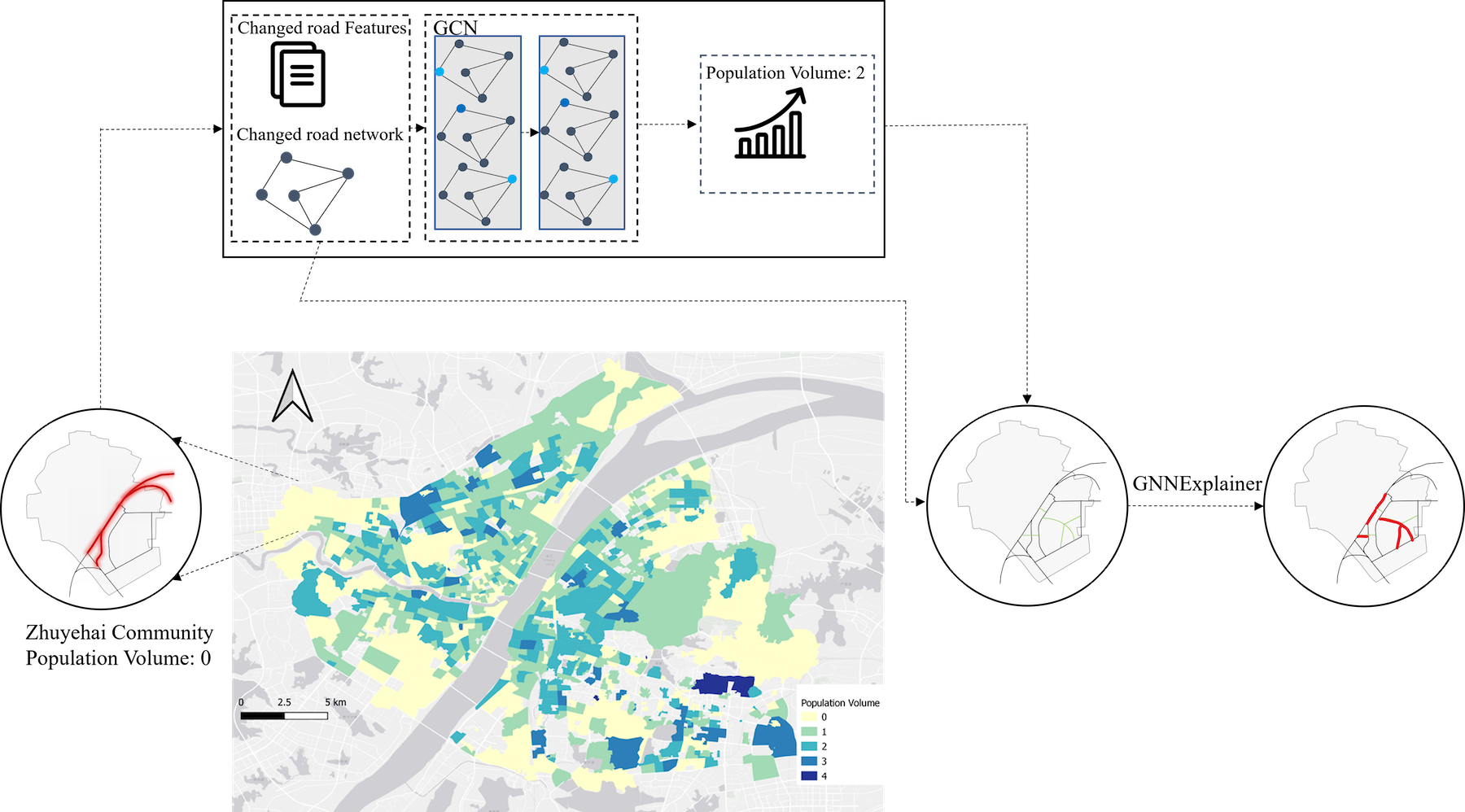
Geospatial artificial intelligence (GeoAI) is proliferating in urban analytics, where graph neural networks (GNNs) have become one of the most popular methods in recent years. However, along with the success of GNNs, the black box nature of AI models has led to various concerns (e.g. algorithmic bias and model misuse) regarding their adoption in urban analytics, particularly when studying socio-economics where high transparency is a crucial component of social justice. Therefore, the desire f...| Urban Analytics Lab | Singapore
Public transit agencies have amassed substantial data through on-board and off-board sensors over the years. While data collection was the primary focus, there is now a shift towards deriving actionable insights from this wealth of information.| Urban Analytics Lab | Singapore
Digital twin technology has great potential to transform urban planning. However, the governance aspects of city-scale digital twins (CDTs)— a virtual representation of urban environments —are understudied.| Urban Analytics Lab | Singapore
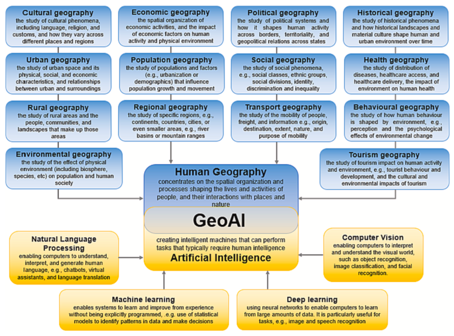
This paper brings a comprehensive systematic review of the application of geospatial artificial intelligence (GeoAI) in quantitative human geography studies, including the subdomains of cultural, economic, political, historical, urban, population, social, health, rural, regional, tourism, behavioural, environmental and transport geography.| Urban Analytics Lab | Singapore
Urban microclimate prediction is crucial for various fields, including Building Performance Simulation (BPS), outdoor thermal comfort, building life cycle, and residential health. Existing methods involve using classical weather file data, such as Typical Meteorological Years (TMY), or machine learning techniques for time-based forecasting. However, the incorporation of both spatial and temporal dimensions and land use/land cover (LULC) data is seldom considered. This paper proposes a novel a...| Urban Analytics Lab | Singapore
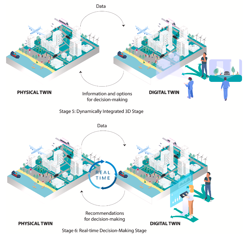
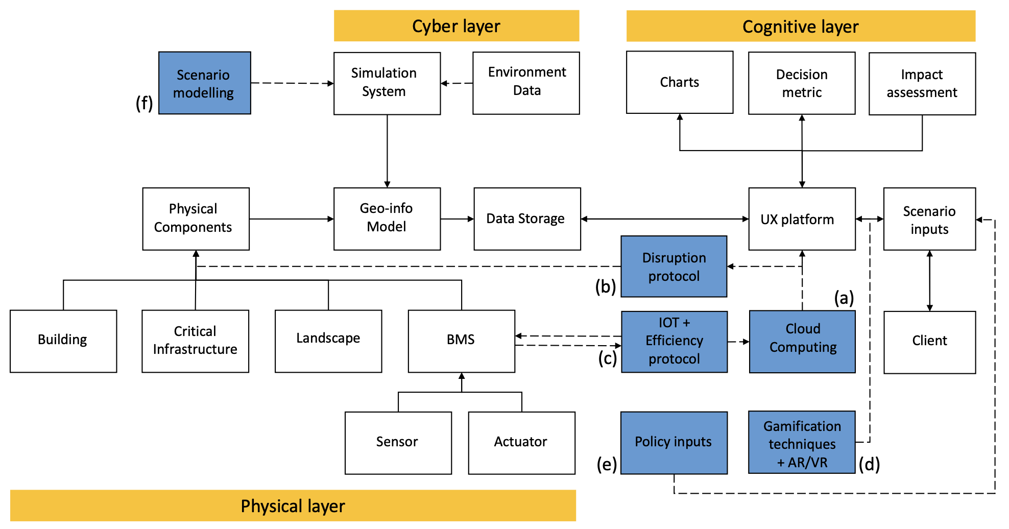
Digital twins have gained increasing attention as a tool to facilitate decision-making in the cities. However, the current discourse predominantly focuses on technical aspects while overlooking the human aspect in urban digital twins. This work proposes a conceptual framework that addresses the role of humans in relation to the urban environment, therefore highlighting the social value of urban digital twins. The proposed framework is subsequently implemented in a specific case study of outdo...| Urban Analytics Lab | Singapore
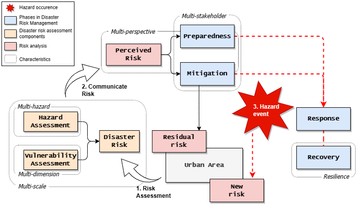
Urban areas and cities face risks caused by the compounding impacts of urbanization and increasing frequency of disasters. The importance of implementing disaster risk management integrated with strategies to achieve sustainable urban development is highlighted by the United Nations Office for Disaster Risk Reduction (UNDRR) through the Sendai Framework for Disaster Risk Reduction 2015–2030 (SFDRR), which provides guidelines for monitoring and reporting the implementation of disaster risk r...| Urban Analytics Lab | Singapore
Most studies of urban morphology rely on morphometrics, such as building area and street length. However, these methods often fall short in capturing visual patterns that carry abundant information about the configuration of urban elements and how they interact spatially. In this study, we introduce a novel method for learning morphology features based on figure-ground maps, which leverages recent developments in computer vision. Our method facilitates discovering and comparing urban form typ...| Urban Analytics Lab | Singapore
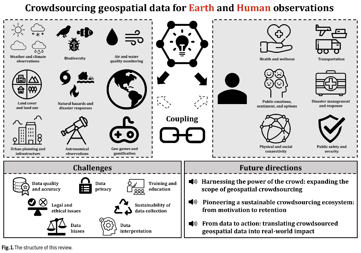
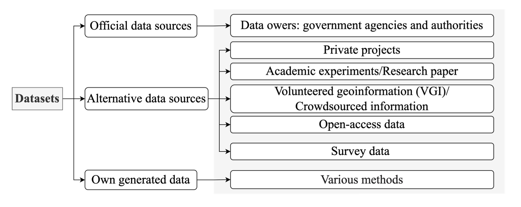
The transformation from authoritative to user-generated data landscapes has garnered considerable attention, notably with the proliferation of crowdsourced geospatial data. Facilitated by advancements in digital technology and high-speed communication, this paradigm shift has democratized data collection, obliterating traditional barriers between data producers and users. While previous literature has compartmentalized this subject into distinct platforms and application domains, this review ...| Urban Analytics Lab | Singapore
Urban spaces have become complex, being shaped by diverse human behaviours. Therefore, the sustainability of development has faced various challenges ranging from pollution to equity in accessibility to activity spaces and opportunities. Using spatial big data and new computing technologies is an effective way to a better understanding of the interaction between individuals and urban environments, which would be beneficial to tackle urban challenges. This workshop focuses on new advanced tech...| Urban Analytics Lab | Singapore
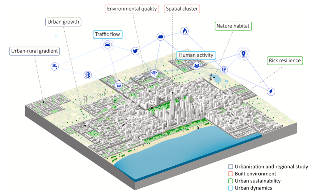
Urban sensing has been an important topic in the past decades, and research has been amplified in the last several years with the emergence of new urban data sources and advancements in GeoAI. This chapter gives a high-level overview of the applications of GeoAI for urban sensing, which have multiplied across various domains. It reviews four examples of GeoAI applied for urban sensing, which span a variety of data sources, techniques developed, and application domains such as urban sustainabi...| Urban Analytics Lab | Singapore
The well-being of residents is considerably influenced by the quality of their environment. However, due to the lack of large-scale quantitative and longitudinal evaluation methods, it has been challenging to assess residents' satisfaction and achieve social inclusion goals in neighborhoods. We develop a novel cost-effective method that utilizes time series street view imagery for evaluating and monitoring visual environmental quality in neighborhoods. Unlike most research that relies on site...| Urban Analytics Lab | Singapore
Construction materials play an important role in environmental impacts and make cities big resource consumers. To assess the sustainability of cities, the combined use of Life Cycle Assessment (LCA) and Material Flow Analysis (MFA) is considered effective to analyze construction material stock and flows. However, exhaustive data is required for such analyses, making LCA and MFA difficult to apply at the urban scale. Building information, the essential ingredient, is rarely available openly. C...| Urban Analytics Lab | Singapore
Urban heat island (UHI) is considered a serious environmental issue in highly urbanized cities such as Singapore. To better quantify the UHI intensity, the local climate zones (LCZ) classification scheme was adopted to characterize land covers, and describe and compare their thermal performance. There are three commonly used LCZ classification approaches: manual sampling,World Urban Database and Access Portal Tools (WUDAPT) processing method using remote sensing, and geographical information ...| Urban Analytics Lab | Singapore
Efficient usage and management of abundant data are crucial for organisations, especially in the light of a lack of in-depth IT knowledge. Digital twins (DTs) are particularly expected to assist organisational processes, as behaviours of physical components are realistically represented by them using data for individual use cases. Nevertheless, DTs are extremely reliant on their use cases, leading to an extensive DT catalogue. However, a conclusive list of use cases for this accumulation of f...| Urban Analytics Lab | Singapore
Traditional approaches for visual perception and evaluation of river landscapes adopt on-site surveys or assessments through photographs. The former is expensive, hindering large-scale analyses, and it is conducted only on street-level or top-down imagery. The latter only reflects the subjective perception and also entails a laborious process. Addressing these challenges, this study proposes an alternative: a novel workflow for visual analysis of urban river landscapes by combining unmanned a...| Urban Analytics Lab | Singapore
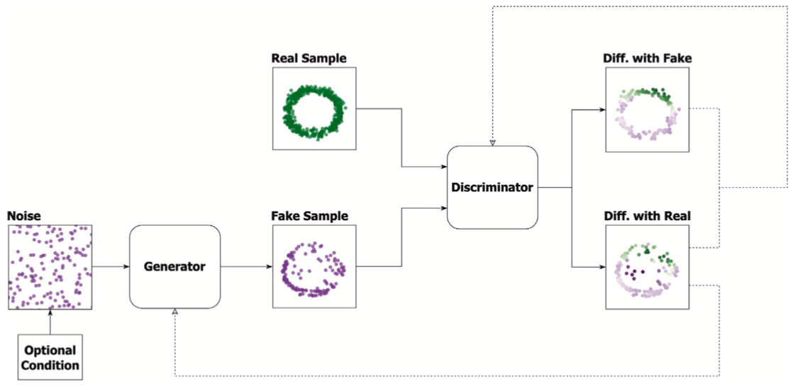
Generative Adversarial Networks (GANs) are a type of deep neural network that have achieved many state-of-the-art results for generative tasks. GANs can be useful in the built environment, from processing large-scale urban mobility data and remote sensing images at the regional level, to performance analysis and design generation at the building level. We analyzed 100 articles to provide a comprehensive state-of-the-art review on how GANs are currently applied to solve challenging tasks in th...| Urban Analytics Lab | Singapore
Unsupervised learning (UL) has a long and successful history in untangling the complexity of cities. As the counterpart of supervised learning, it discovers patterns from intrinsic data structures without crafted labels, which is believed to be the key to real AI-generated decisions. This paper provides a systematic review of the use of UL in urban studies based on 140 publications. Firstly, the topic, technique, application, data type, and evaluation method of each paper are recorded, derivi...| Urban Analytics Lab | Singapore
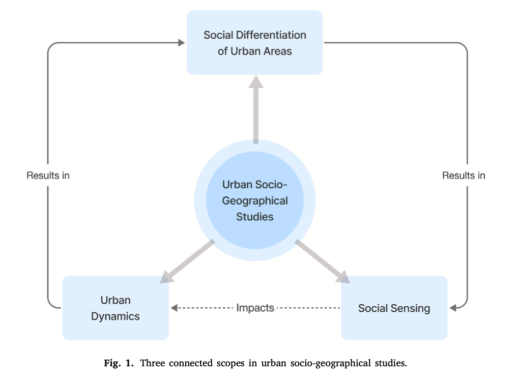
Urban Geography studies forms, social fabrics, and economic structures of cities from a geographic perspective. Catalysed by the increasingly abundant spatial big data, Urban Geography seeks new models and research paradigms to explain urban phenomena and address urban issues. Recent years have witnessed significant advances in spatially-explicit geospatial artificial intelligence (GeoAI), which integrates spatial studies and AI, primarily focusing on incorporating spatial thinking and concep...| Urban Analytics Lab | Singapore
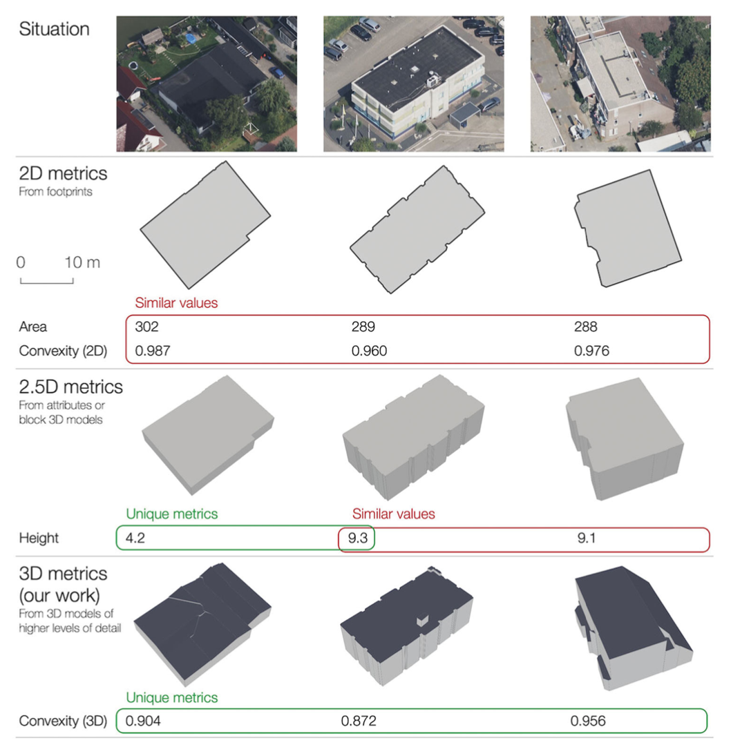
Urban morphology is important in a broad range of investigations across the fields of city planning, transportation, climate, energy, and urban data science. Characterising buildings with a set of numerical metrics is fundamental to studying the urban form. Despite the rapid developments in 3D geoinformation science, and the growing 3D data availability, most studies simplify buildings to their 2D footprint, and when taking their height into account, they at most assume one height value per b...| Urban Analytics Lab | Singapore
As a developed and densely populated city, Singapore proves to be a vulnerable victim of the effects of climate change. With Singapore heating up twice as fast as the rest of the world, it is highly important that factors contributing to it are identified and analysed to curb this issue and protect the well-being of the population and the environment. Firstly, with the many infrastructures that dot the city, Singapore falls prey to the urban heat island (UHI) effect. Secondly, with the use of...| Urban Analytics Lab | Singapore
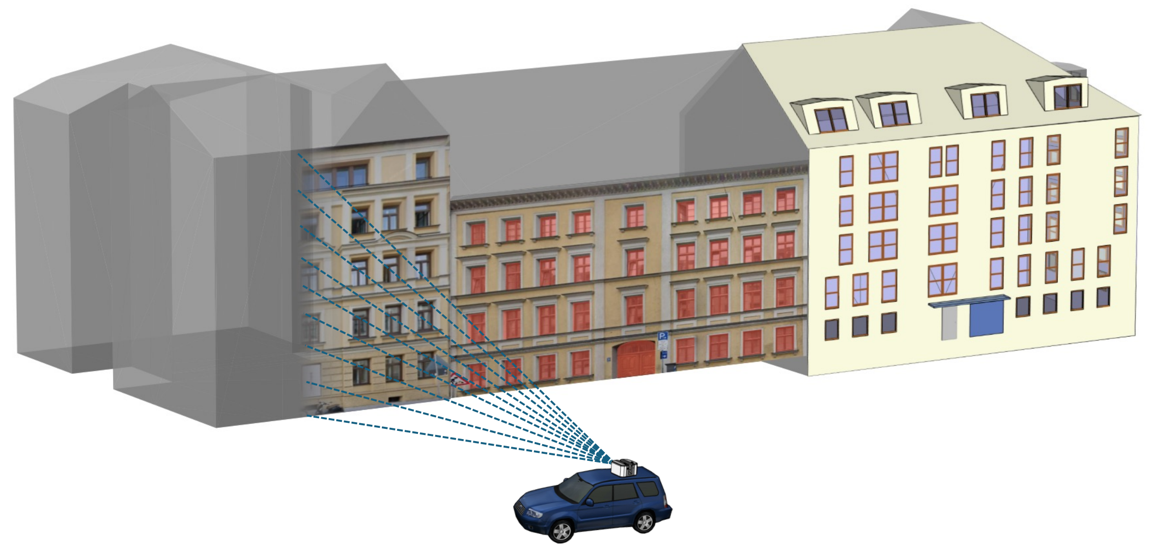
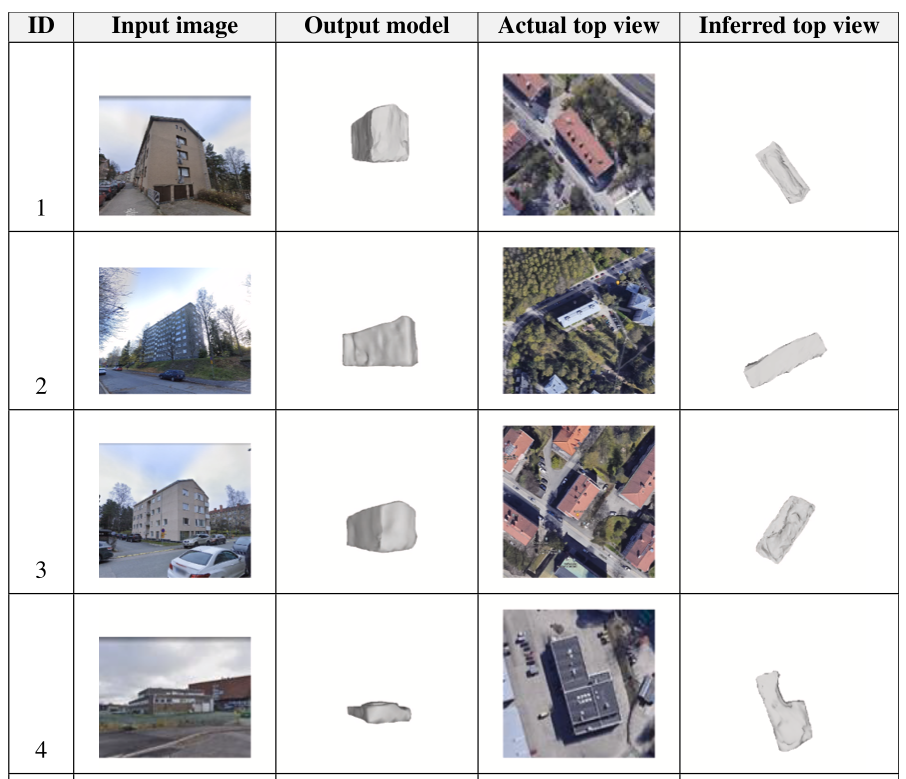
3D building models are an established instance of geospatial information in the built environment, but their acquisition remains complex and topical. Approaches to reconstruct 3D building models often require existing building information (e.g. their footprints) and data such as point clouds, which are scarce and laborious to acquire, limiting their expansion. In parallel, street view imagery (SVI) has been gaining currency, driven by the rapid expansion in coverage and advances in computer v...| Urban Analytics Lab | Singapore
There is a prevailing trend to study urban morphology quantitatively thanks to the growing accessibility to various forms of spatial big data, increasing computing power, and use cases benefiting from such information. The methods developed up to now measure urban morphology with numerical indices describing density, proportion, and mixture, but they do not directly represent morphological features from the human's visual and intuitive perspective. We take the first step to bridge the gap by ...| Urban Analytics Lab | Singapore
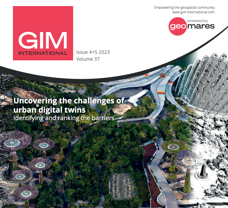
Street view imagery has rapidly ascended as an important data source for geospatial data collection and urban analytics, deriving insights and supporting informed decisions. Such surge has been mainly catalysed by the proliferation of large-scale imagery platforms, advances in computer vision and machine learning, and availability of computing resources. We screened more than 600 recent papers to provide a comprehensive systematic review of the state of the art of how street-level imagery is ...| Urban Analytics Lab | Singapore
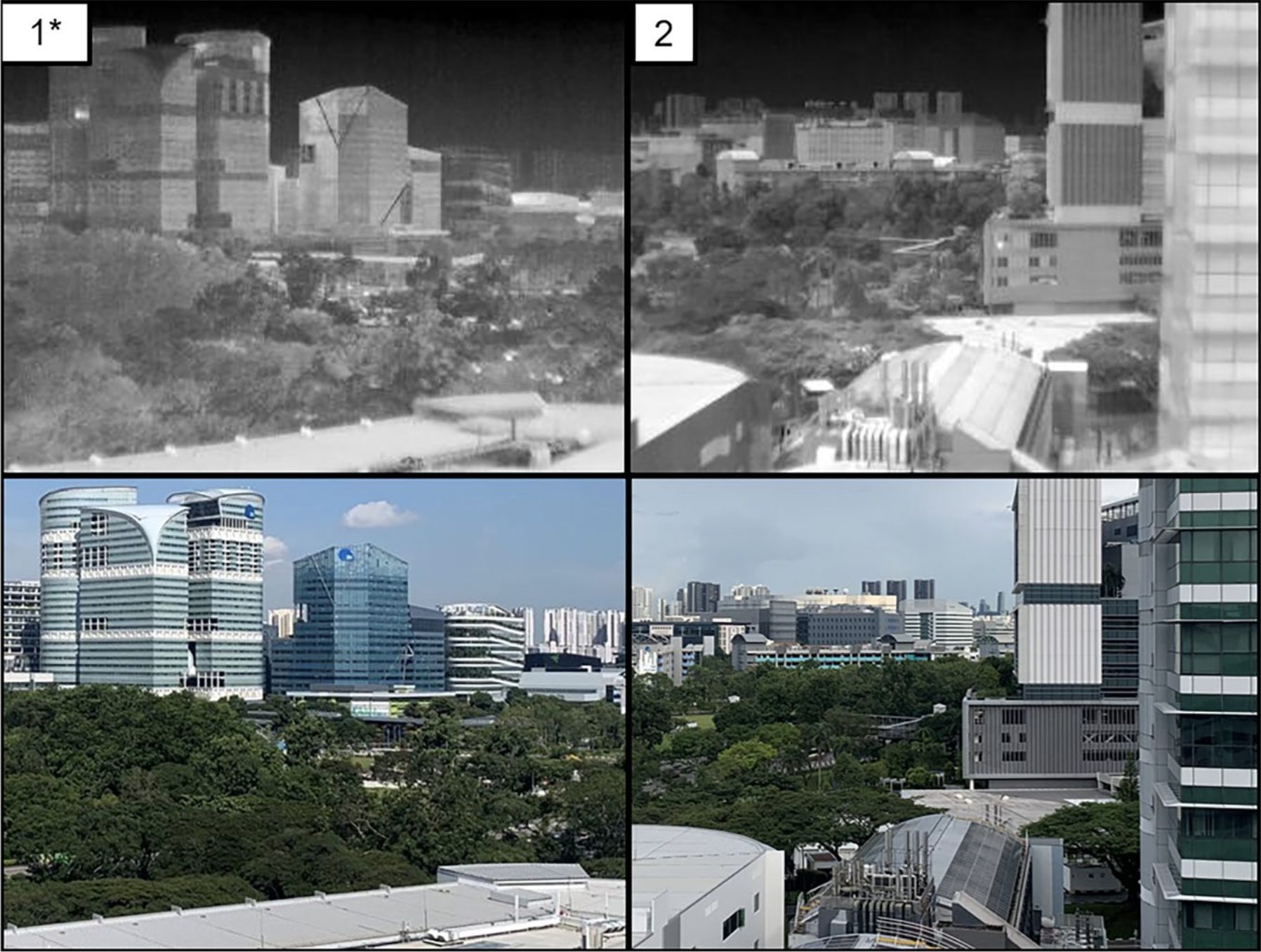
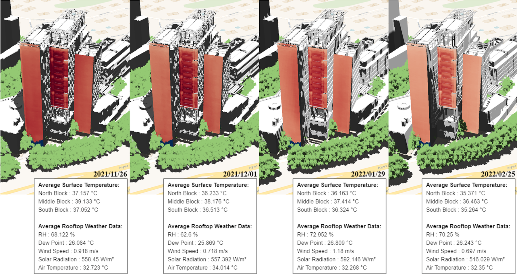
This paper describes a dataset collected by infrared thermography, a non-contact, non-intrusive technique to acquire data and analyze the built environment in various aspects. While most studies focus on the city and building scales, an observatory installed on a rooftop provides high temporal and spatial resolution observations with dynamic interactions on the district scale. The rooftop infrared thermography observatory with a multi-modal platform capable of assessing a wide range of dynami...| Urban Analytics Lab | Singapore
The building sector plays a crucial role in the worldwide decarbonization effort, accounting for significant portions of energy consumption and environmental effects. However, the scarcity of open data sources is a continuous challenge for built environment researchers and practitioners. Although several efforts have been made to consolidate existing open datasets, no database currently offers a comprehensive collection of building data types with all subcategories and time granularities (e.g...| Urban Analytics Lab | Singapore
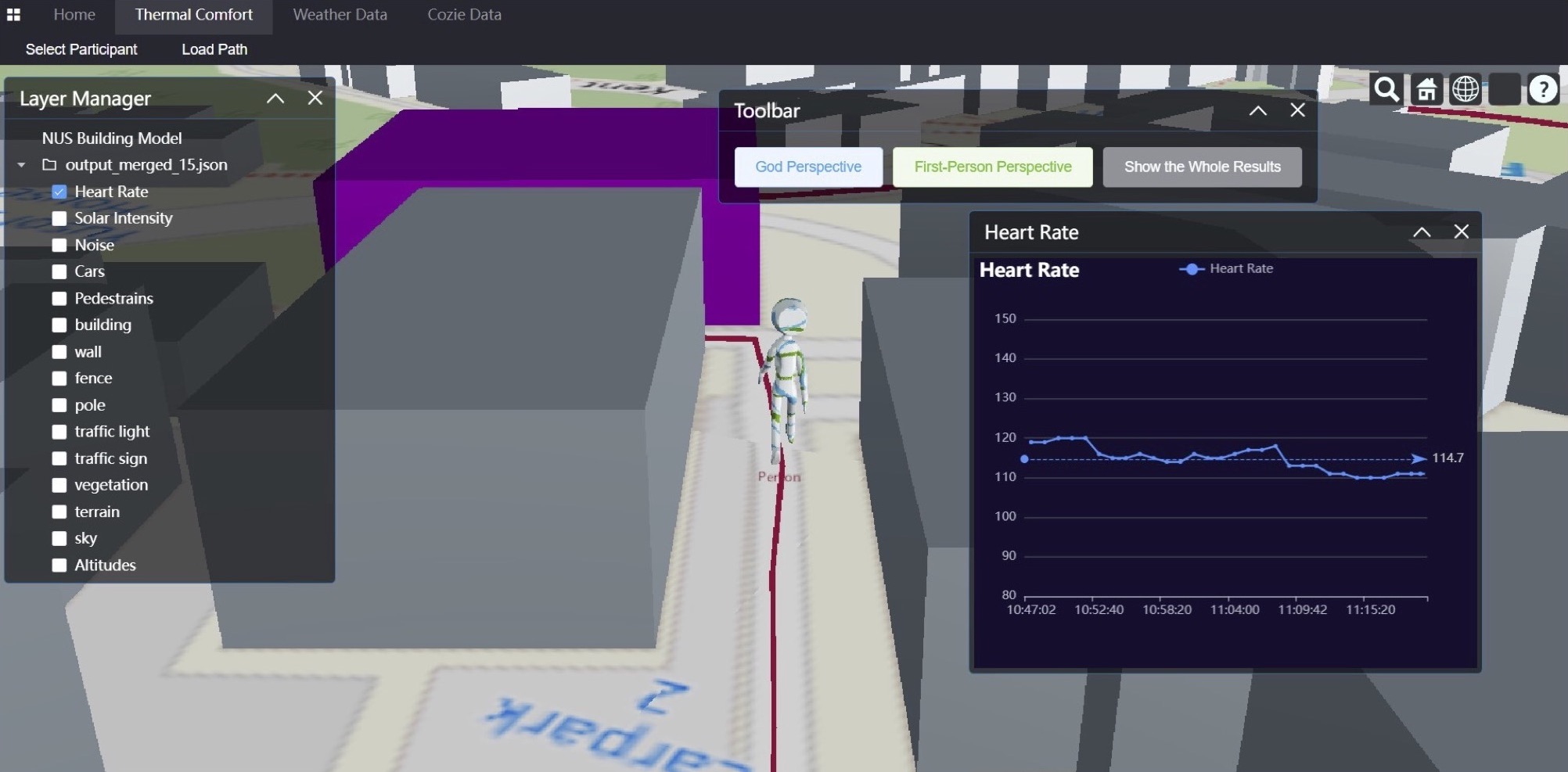
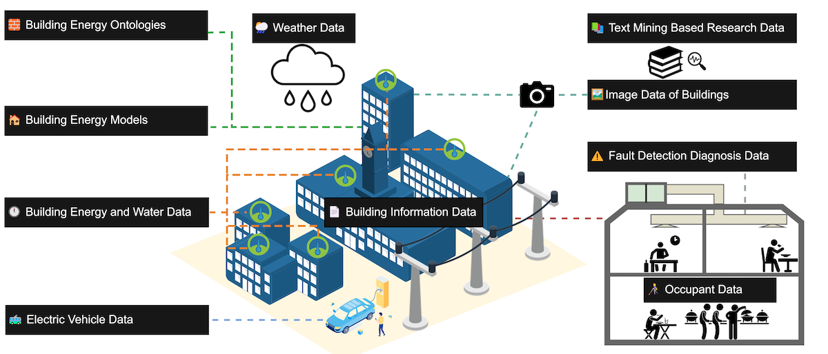
Recently, the concept of a digital twin for the built environment has received significant attention due to its potential benefits to urban planners, engineers, and designers. The development of tools that aid in integrating real-world physical systems with digital capabilities is essential for advancing digital twin technology. In this work, we present one such digital twin tool that integrates the longitudinal thermal envelope data of buildings on the campus of the National University of Si...| Urban Analytics Lab | Singapore
The productivity and satisfaction of humans in the built environment is impacted significantly by their exposure to high temperature and various noise sources. This paper outlines the city-scale collection of 12,009 smartwatch-driven micro-survey responses that were collected alongside 2,825,243 physiological and environmental measurements from 106 people using the open-source Cozie-Apple platform combined with geolocation-driven urban digital twin metrics from the Urbanity Python package. Th...| Urban Analytics Lab | Singapore
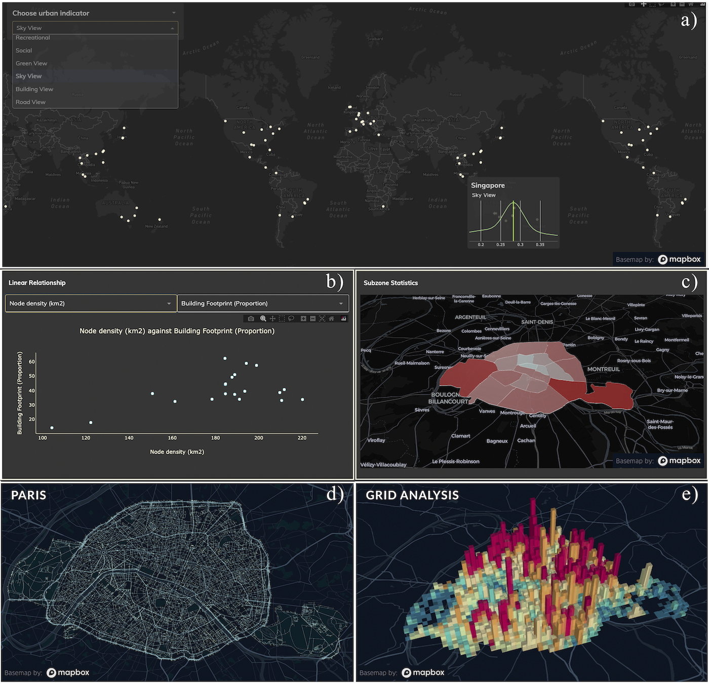
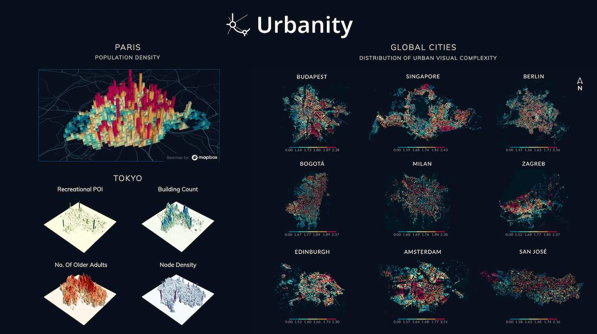
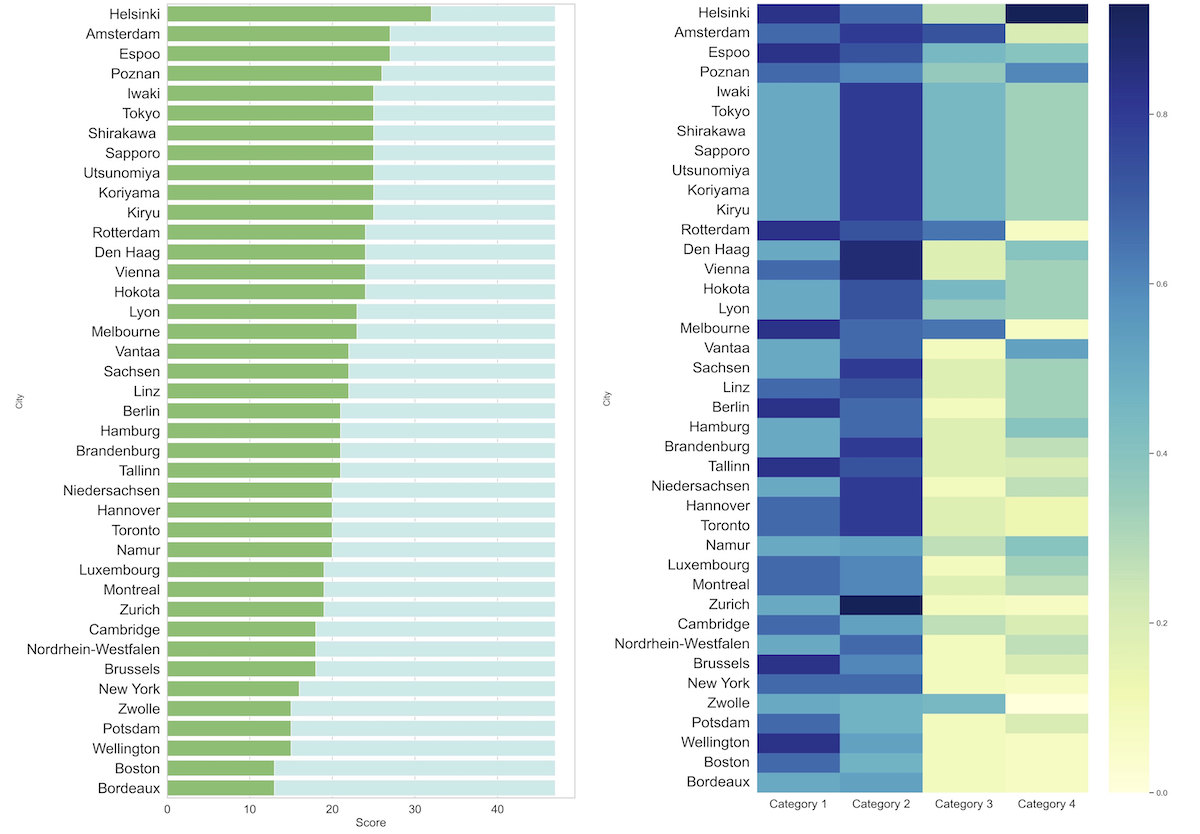
Urban network analytics has become an essential tool for understanding and modeling the intricate complexity of cities. We introduce the Urbanity data repository to nurture this growing research field, offering a comprehensive, open spatial network resource spanning 50 major cities in 29 countries worldwide. Our workflow enhances OpenStreetMap networks with 40 + high-resolution indicators from open global sources such as street view imagery, building morphology, urban population, and poin...| Urban Analytics Lab | Singapore
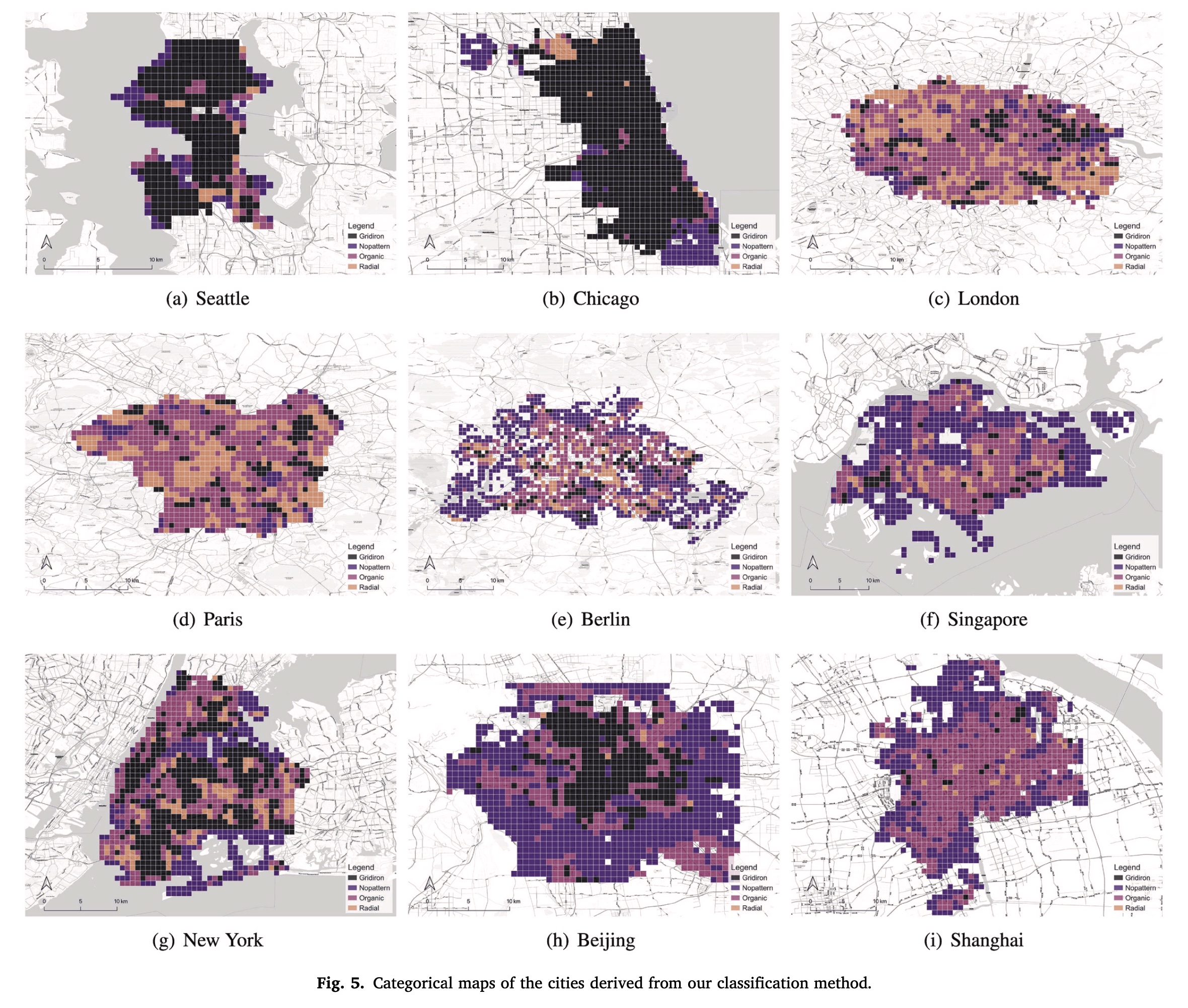
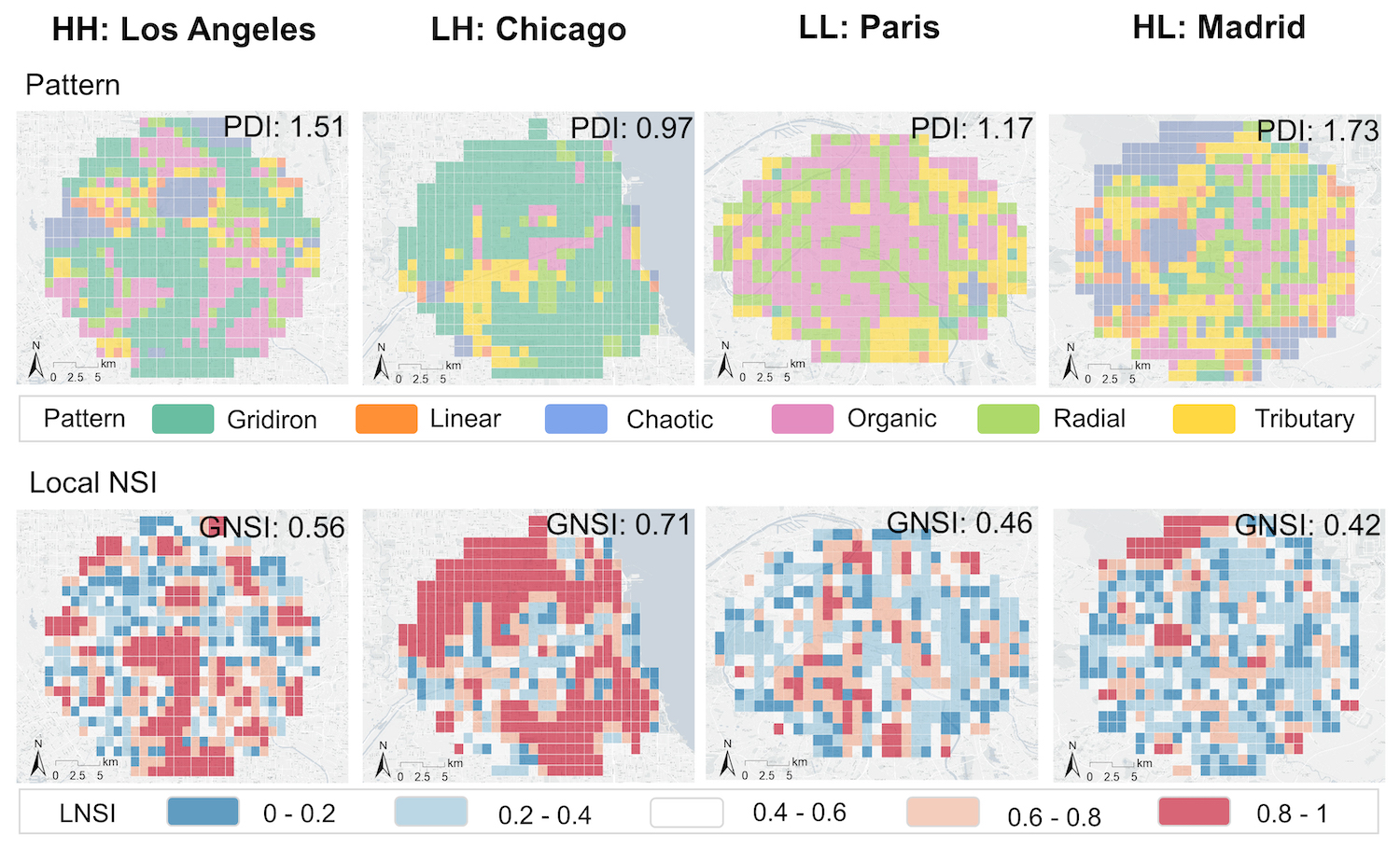
Urban road networks (URNs) are ubiquitous and essential components of cities. Visually, they present diverse patterns that embody latent planning principles. However, we still lack a global insight into such patterns. In this paper, we propose a scalable deep learning-based framework to automate accurate and multiscale classification of road network patterns in cities and present a comprehensive global implementation on 144 major cities around the world, yielding their multiscale pattern prof...| Urban Analytics Lab | Singapore
Urban networks play a vital role in connecting multiple urban components and developing our understanding of cities and urban systems. Despite the significant progress we have made in understanding how city networks are connected and spread out, we still have a lot to learn about the meaning and context of these networks. The increasing availability of open data offers opportunities to supplement urban networks with specific location information and create more expressive urban machine-learni...| Urban Analytics Lab | Singapore
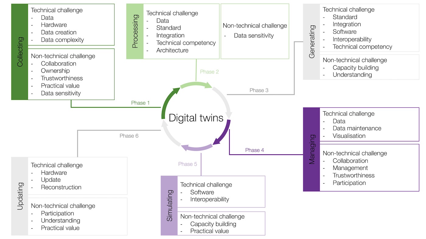
Urban digital twins, as representations of physical assets in the cities, enable two- way interaction with real-world counterparts, facilitating analytical operations and simulations in the virtual urban environment. Despite their growing popularity, many challenges to operating digital twins remain, hindering their design and implementation, but they are rarely discussed. Here, the authors identify the challenges of operating digital twins in the urban context through a bifurcated and multi-...| Urban Analytics Lab | Singapore
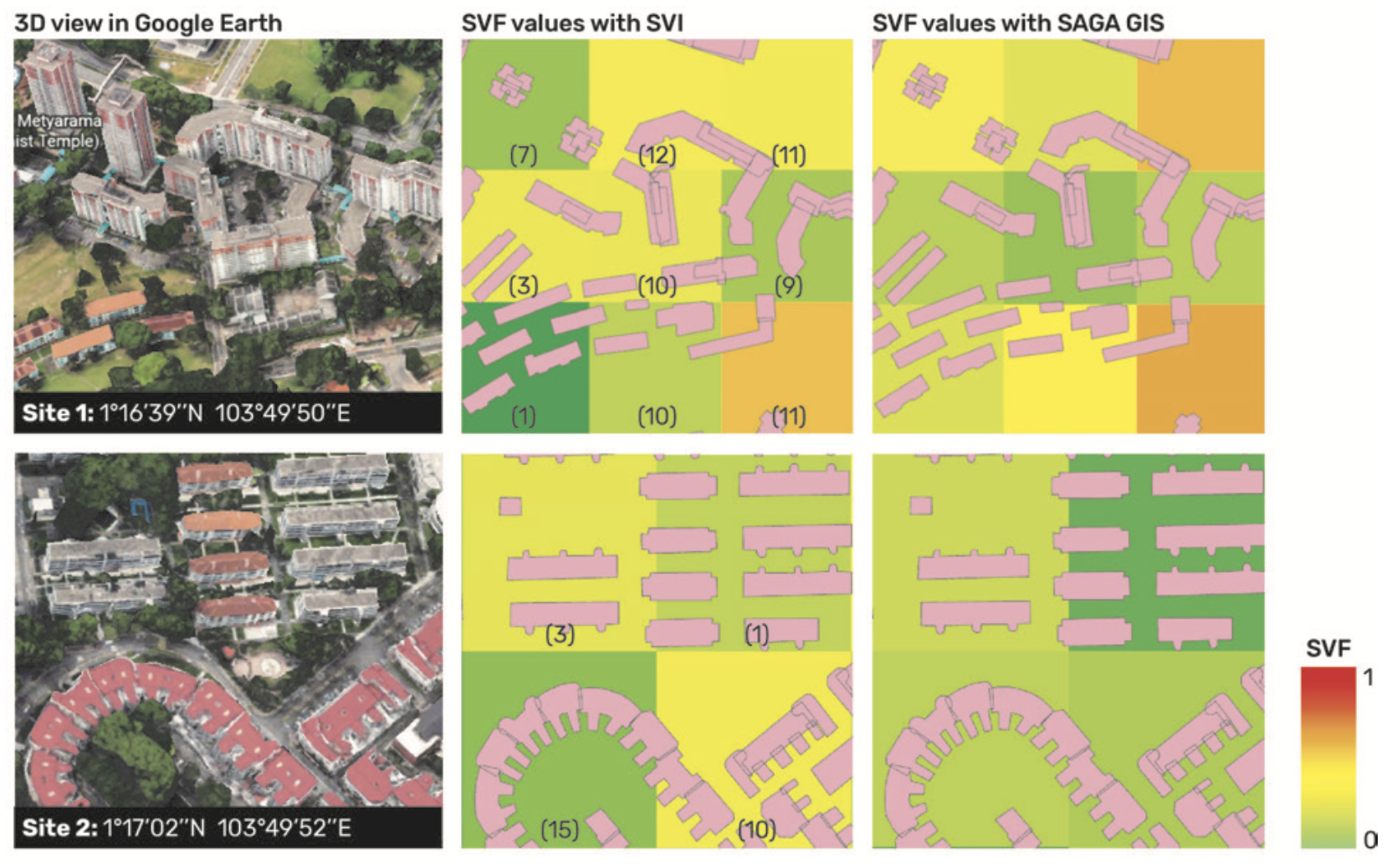
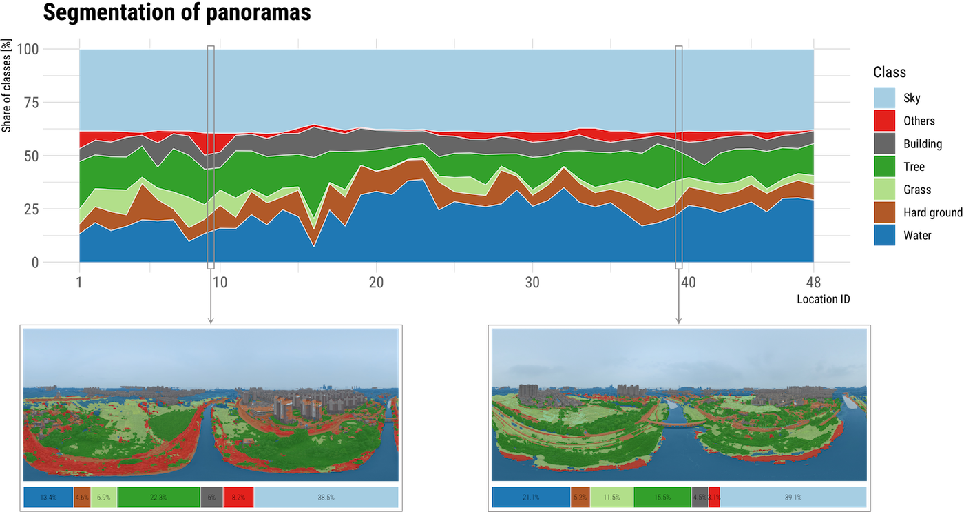
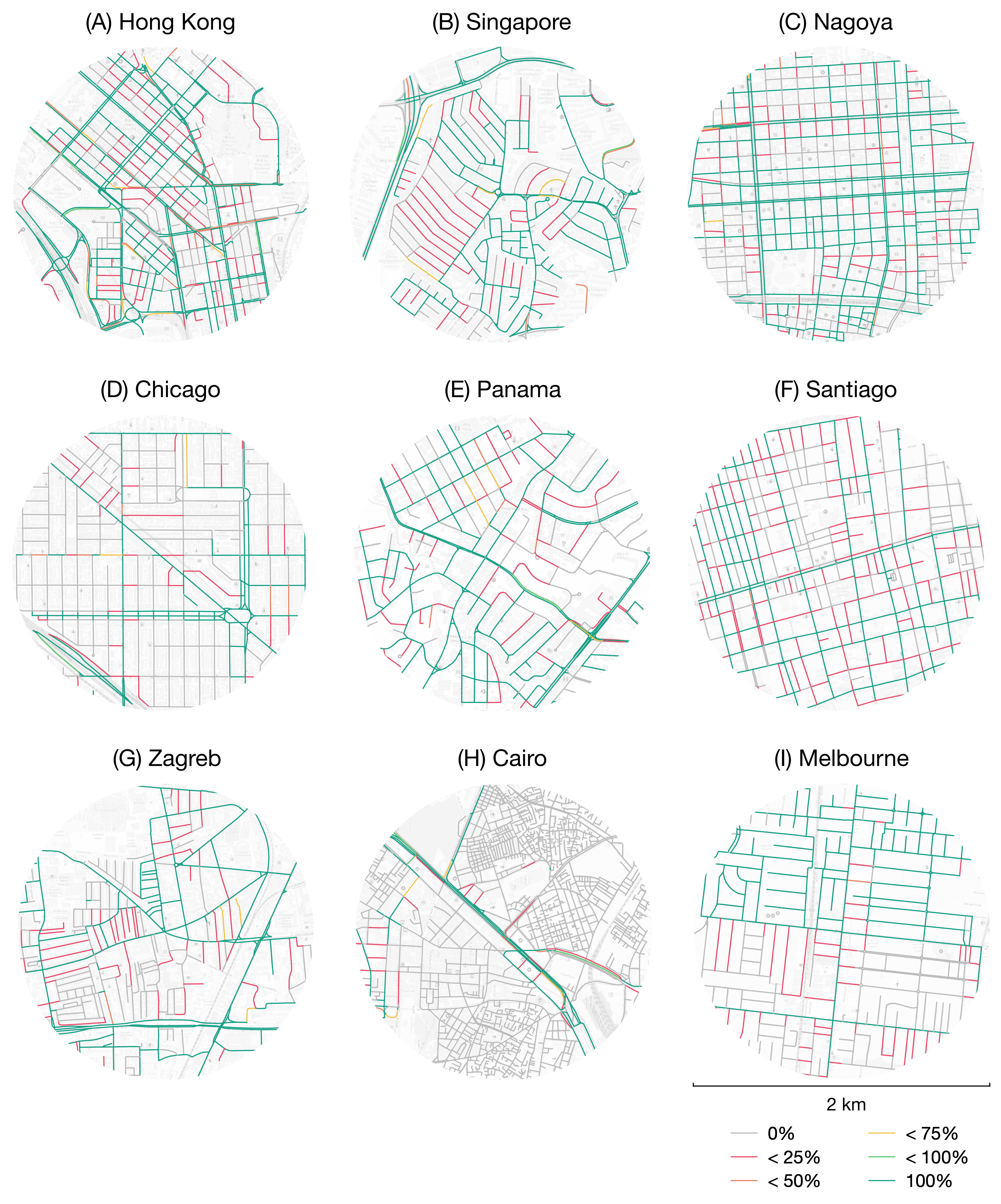
Street View Imagery (SVI) is crucial in estimating indicators such as Sky View Factor (SVF) and Green View Index (GVI), but (1) approaches and terminology differ across fields such as planning, transportation and climate, potentially causing inconsistencies; (2) it is unknown whether the regularly used panoramic imagery is actually essential for such tasks, or we can use only a portion of the imagery, simplifying the process; and (3) we do not know if non-panoramic (single-frame) photos typic...| Urban Analytics Lab | Singapore
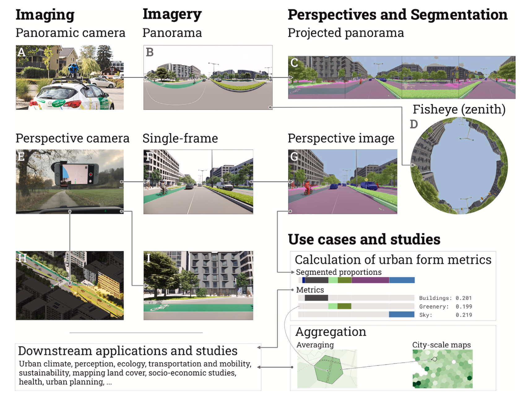
There is a growing interest in deriving insights about cities from crowdsourced data. We advance the discourse by employing homestay guest experience to sense urban characteristics. We evaluate the relationship between subjective perceptions and objective indicators thanks to rich information in textual reviews that we posit reflect urban qualities. Next, we investigate dominant topics about urban characteristics in Airbnb reviews (transportation, greenery, amenities, safety, and noise) with ...| Urban Analytics Lab | Singapore
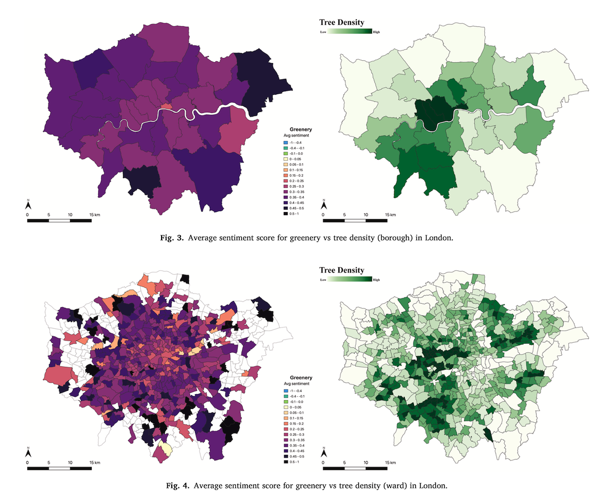
Building Energy Modeling tools help forecast the energy performance of buildings. Urban energy models (UBEMs) emerged as important instruments to analyze the energy performance of buildings aggregated at different spatial resolutions, from the building level to the district level. They heavily rely on available data on geometries and measurements to create accurately calibrated energy models. However, limited research has been conducted to understand the impact of spatial and temporal resolut...| Urban Analytics Lab | Singapore
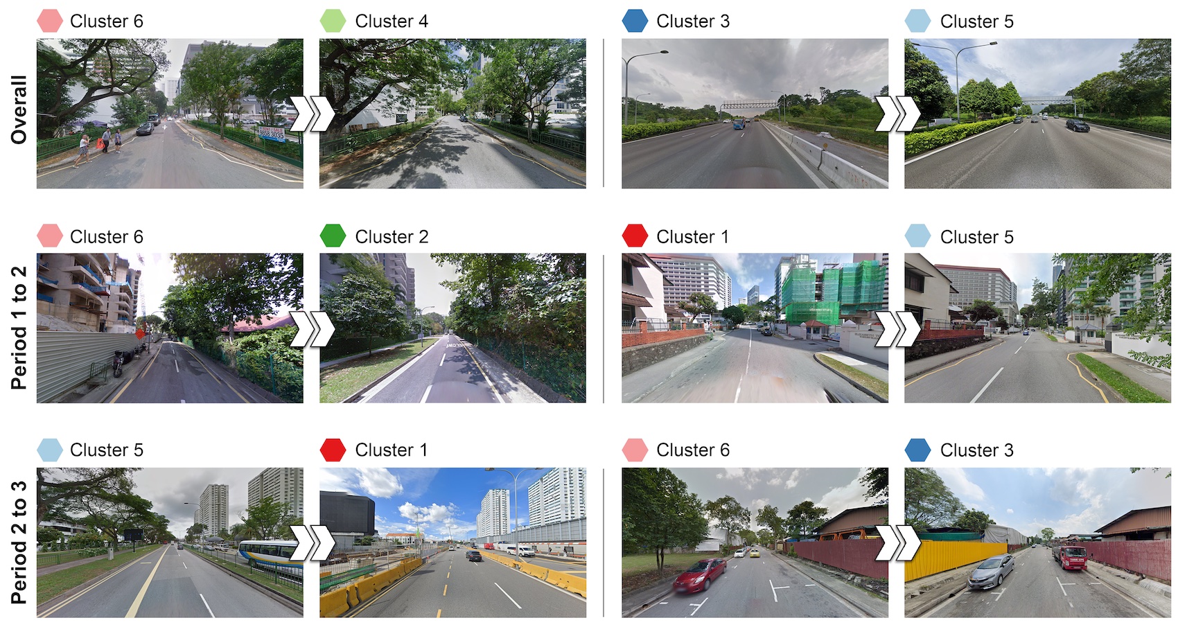
The visual landscape plays a pivotal role in urban planning and healthy cities. Recent studies of visual evaluation focus on either objective or subjective approach, while describing the visual character holistically and monitor its evolution remains challenging. This study introduces an embedding-driven clustering approach that integrates both physical and perceptual attributes to infer the spatial structure of the visual environment, and investigates its spatio-temporal evolution. Singapore...| Urban Analytics Lab | Singapore
The accurate prediction of travel demand by bus is crucial for effective urban mobility demand management. However, most models of travel demand prediction by bus tend to focus on the bus’s spatiotemporal dependencies, while ignoring the interactions between buses and other transportation modes, such as metros and taxis. We propose a Multiview Spatiotemporal Graph Neural Network (MSTGNN) model to predict short-term travel demand by bus. It emphasizes the ability to capture the interaction d...| Urban Analytics Lab | Singapore
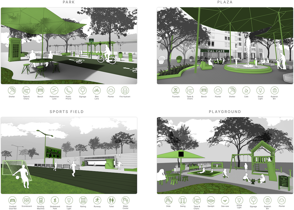
Public open space (POS) is essential to urban areas. Assessing them usually requires tedious approaches such as fieldwork and manual processes. Street View Imagery (SVI) and Computer Vision (CV) have been adopted in some urban environment research, bringing fine granularity and human perspective. However, limited aspects have been subject in these studies, and SVI and CV have not been used for holistic POS assessment. This research introduces a novel approach of employing them in conjunction ...| Urban Analytics Lab | Singapore
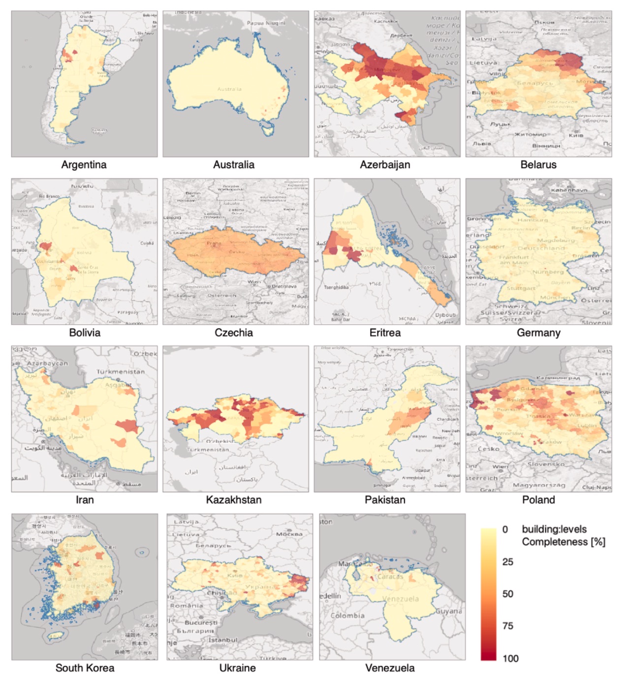
Geospatial data of the building stock is essential in many domains pertaining to the built environment. These datasets are often provided by governments, but crowdsourcing them has surged in the last decade. Nowadays, OpenStreetMap (OSM) — the most popular Volunteered Geographic Information (VGI) platform — contains geospatial and descriptive data on more than 500 million buildings worldwide collected by millions of contributors, and it is increasingly used in studies ranging from energy ...| Urban Analytics Lab | Singapore
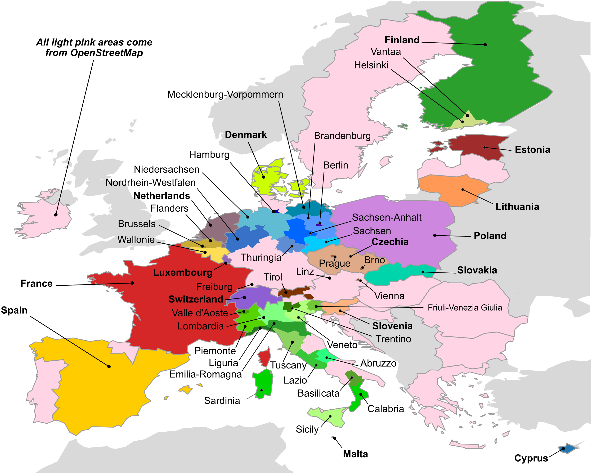
Building stock management is becoming a global societal and political issue, inter alia because of growing sustainability concerns. Comprehensive and openly accessible building stock data can enable impactful research exploring the most effective policy options. In Europe, efforts from citizen and governments generated numerous relevant datasets but these are fragmented and heterogeneous, thus hindering their usability. Here, we present EUBUCCO v0.1, a database of individual building footprin...| Urban Analytics Lab | Singapore
With the rise of GeoAI research, streetscape imagery has received extensive attention due to its comprehensive coverage, abundant information, and accessibility. However, obtaining a holistic spatial–temporal scene representation is difficult because places are often composed of multiple images from different angles, times and locations. This problem also exists in other types of geo-tagged imagery. To solve it, we propose a purely visual, robust, and reliable method for urban function iden...| Urban Analytics Lab | Singapore
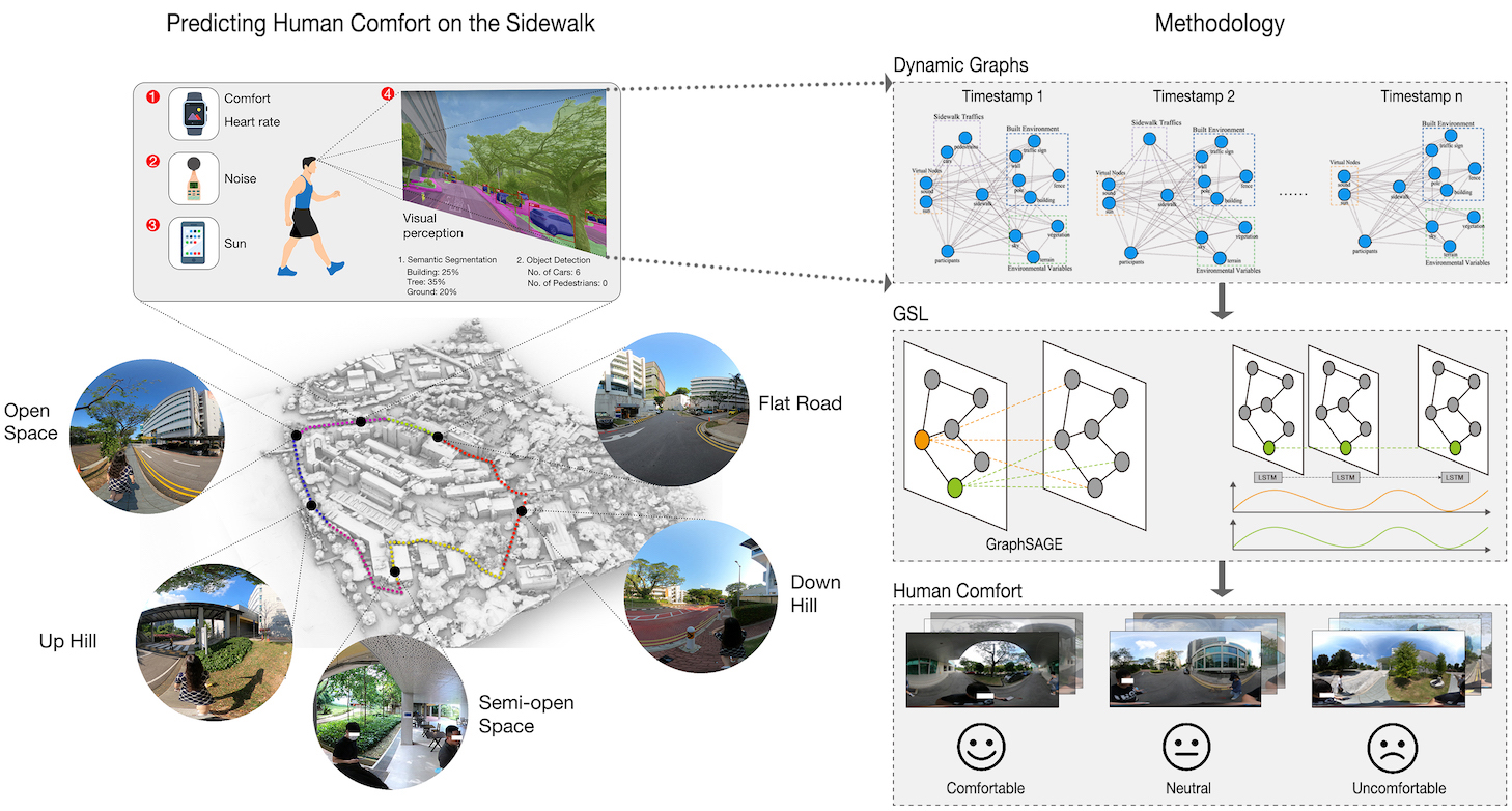
Conventional sidewalk studies focused on quantitative analysis of sidewalk walkability at a large scale which cannot capture the dynamic interactions between the environment and individual factors. Embracing the idea of Tech for Social Good, Urban Digital Twins seek AI-empowered approaches to bridge humans with digitally-mediated technologies to enhance their prediction ability. We employ GraphSAGE-LSTM, a geo-spatial artificial intelligence (GeoAI) framework on crowdsourced data and computer...| Urban Analytics Lab | Singapore
Understanding human mobility is linked to the dynamics of humans’ complex decision-making but is a critical component in modern applications, ranging from business strategies in supermarkets to the common good amid pandemic crises. Meanwhile, massive data brought by the increasing availability of trajectory recordings and emerging machine learning techniques have led to better trajectory modelling in recent studies. Many approaches have been then proposed to explain the modelling of complex...| Urban Analytics Lab | Singapore
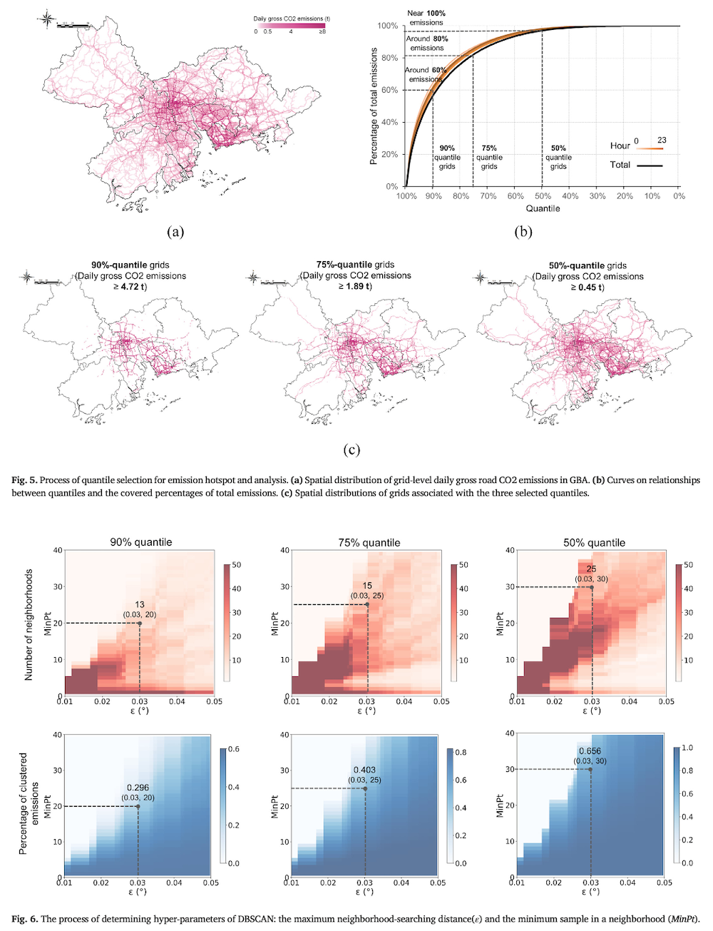
Road transport is a prominent source of carbon emissions. However, fine-grained regional estimations on road carbon dioxide (CO2) emissions are still lacking. This study estimates road CO2 emissions in Guangdong Province, China, at high spatiotemporal resolution, with a bottom-up framework leveraging massive vehicle trajectory data. We unveil the spatiotemporal pattern of regional road CO2 emissions and highlight the contrasts among cities. The Greater Bay Area (GBA) is found to produce 76 % ...| Urban Analytics Lab | Singapore
Many challenges to operate digital twins remain, hindering their design and implementation, and are rarely discussed. Furthermore, issues of social and legal nature are often overlooked. We identify the challenges of operating digital twins in the urban context through a bifurcated and multi-dimensional approach: a systematic literature review and an expert survey. The review organises the identified challenges across technical and non-technical dimensions. As the topic is novel, the corpus i...| Urban Analytics Lab | Singapore
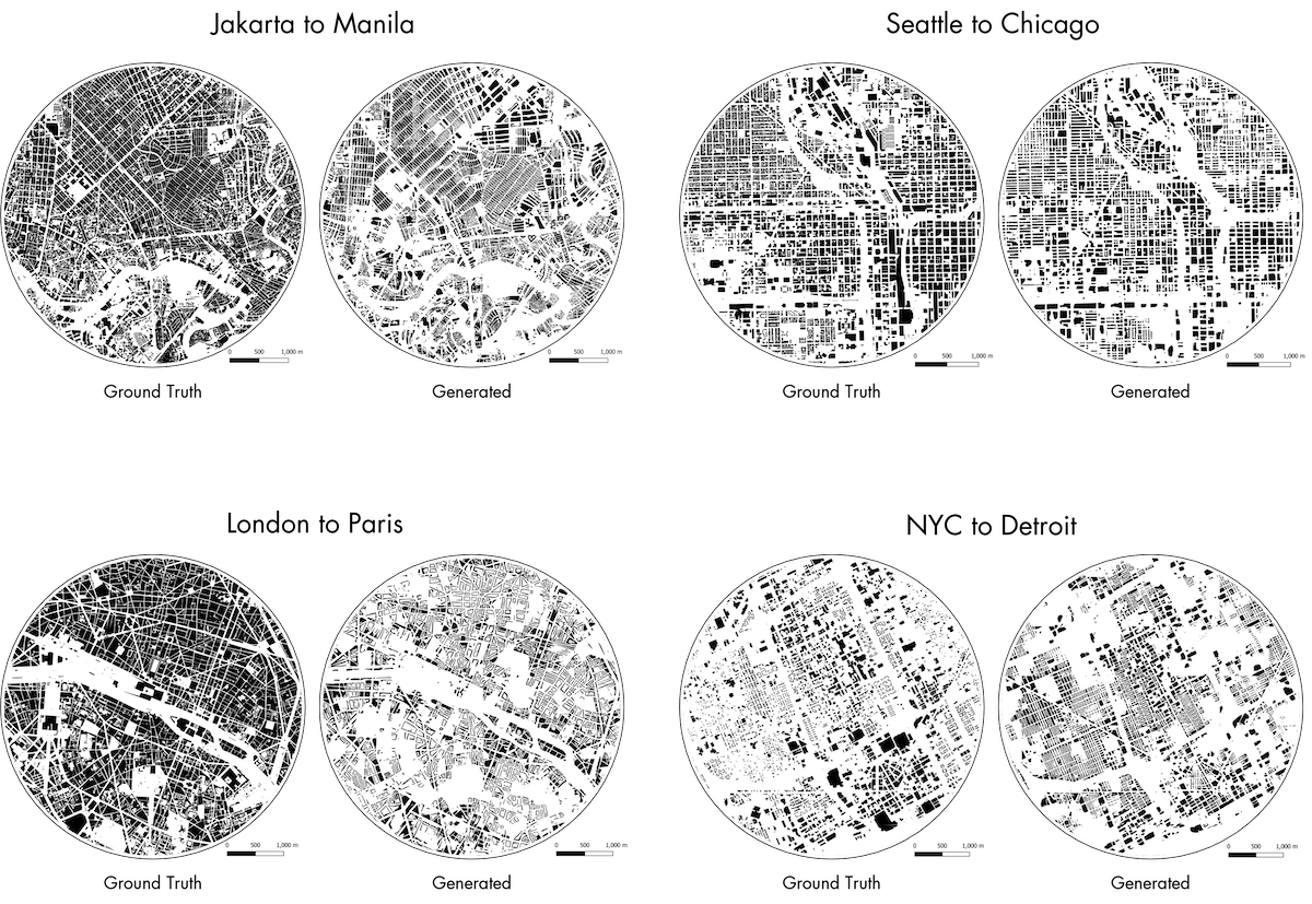
Generative Adversarial Network (GAN) is widely used in many generative problems, including in spatial information sciences and urban systems. The data generated by GANs can achieve high quality to augment downstream training or to complete missing entries in a dataset. GANs can also be used to learn the relationship between two datasets and translate one into another, e.g. road network data into building footprint data. However, such approach has not been developed in the geospatial and urban...| Urban Analytics Lab | Singapore
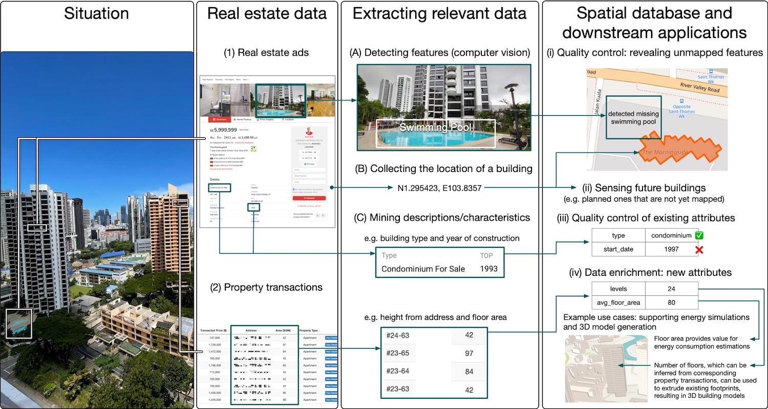
Acquiring spatial data of fine and dynamic urban features such as buildings remains challenging. This paper brings attention to real estate advertisements and property sales data as valuable and dynamic sources of geoinformation in the built environment, but unutilised in spatial data infrastructures. Given the wealth of information they hold and their user-generated nature, we put forward the idea of real estate data as an instance of implicit volunteered geographic information and bring att...| Urban Analytics Lab | Singapore
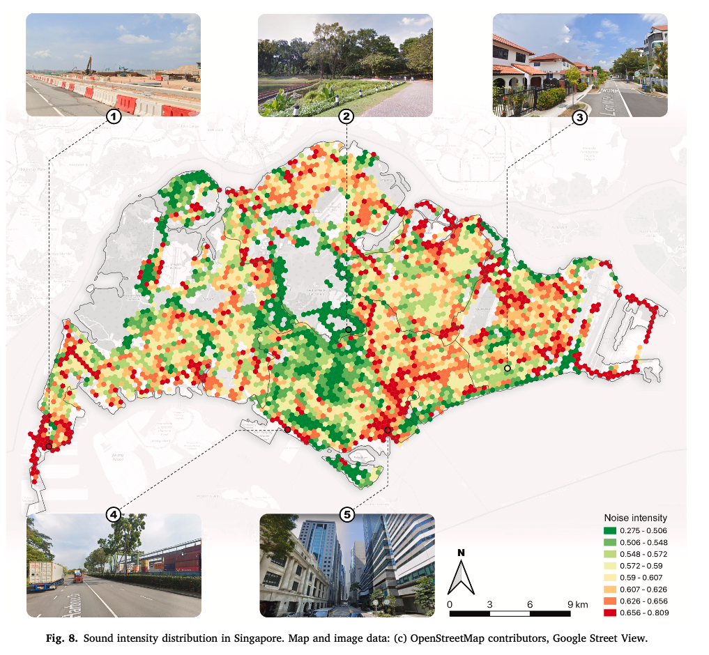
A healthy acoustic environment is an essential component of sustainable cities. Various noise monitoring and simulation techniques have been developed to measure and evaluate urban sounds. However, sensing large areas at a fine resolution remains a great challenge. Based on machine learning, we introduce a new application of street view imagery — estimating large-area high-resolution urban soundscapes, investigating the premise that we can predict and characterize soundscapes without labori...| Urban Analytics Lab | Singapore
Planning for active mobility satisfies many fundamental tenets of good urban design and planning. However, planning for active mobility is a complex endeavour due to numerous local, place-based factors that influence active mobility decisions. Recent advancements in urban data research have demonstrated the effectiveness of deep learning methods in evaluating active mobility potential for urban environments. At present, the incorporation of semantic information from deep learning models and s...| Urban Analytics Lab | Singapore
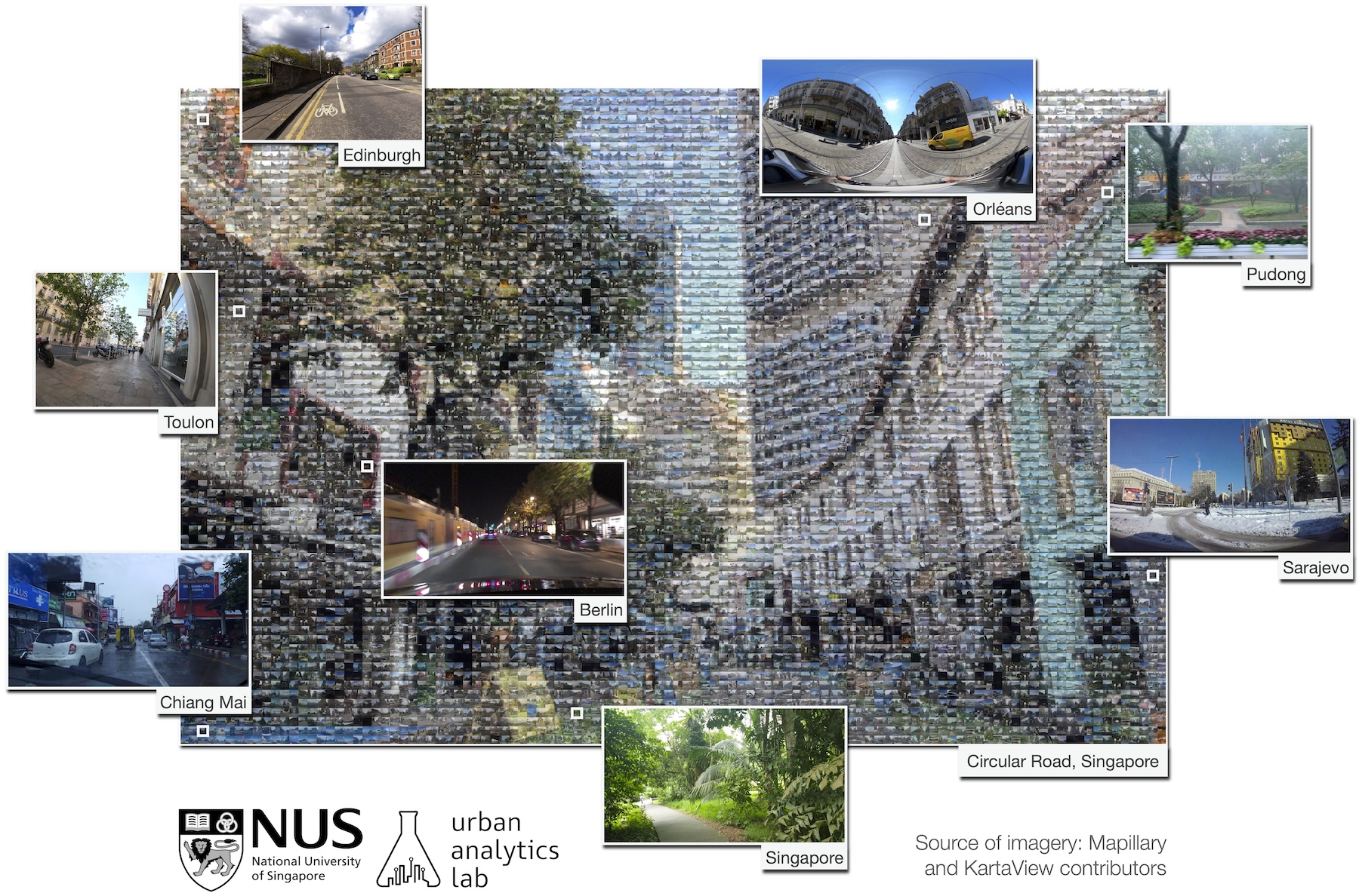
Street view imagery (SVI) is increasingly in competition with traditional remote sensing sources and assuming its domination in myriads of studies, mainly thanks to the omnipresence of commercial services such as Google Street View. Similar to other spatial data, SVI may be of variable quality and burdened with a variety of errors. Recently, this concern has been amplified with the rise of volunteered SVI such as Mapillary and KartaView, which – akin to other instances of Volunteered Geogra...| Urban Analytics Lab | Singapore
3D city models are omnipresent in urban management and simulations. However, instruments for their evaluation have been limited. Furthermore, current instances are scattered worldwide and developed independently, hampering their comparison and understanding practices. While there are developed assessment frameworks in open data, such efforts are generic and not applied to geospatial data. We establish a holistic and comprehensive four-category framework ‘3D City Index’, encompassing 47 cr...| Urban Analytics Lab | Singapore